|
| Mesoscale Discussion 50 |
|
< Previous MD Next MD >
|
|
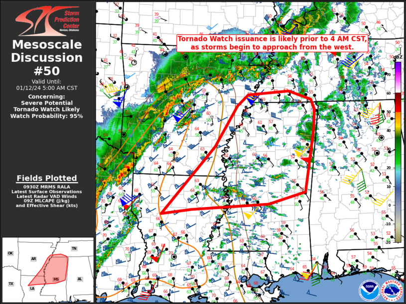
   Mesoscale Discussion 0050
   NWS Storm Prediction Center Norman OK
   0333 AM CST Fri Jan 12 2024

   Areas affected...Northern LA...Southeast AR...Southwest
   TN...central/northern MS

   Concerning...Severe potential...Tornado Watch likely

   Valid 120933Z - 121100Z

   Probability of Watch Issuance...95 percent

   SUMMARY...Tornado Watch issuance is likely by 4 AM CST, as storms
   begin to approach the region from the west.

   DISCUSSION...As a powerful mid/upper-level shortwave trough moves
   across the southern Plains early this morning, ongoing convection
   near the ArkLaTex region is expected to accelerate eastward. A
   surface cyclone is expected to consolidate later this morning near
   the ArkLaMiss area and then rapidly intensify as a 100+ kt midlevel
   jet impinges upon the region. As this occurs, 60s F dewpoints are
   expected to advance as far as northern MS, accompanied by an
   increase in MLCAPE to near 500 J/kg in areas that are currently
   rather cool/stable.

   While there will be some tendency for convection to eventually
   outpace low-level moisture return, organized convection is expected
   to reach parts of northern/central MS and perhaps southwest TN later
   this morning. Low-level flow/shear is already strong (as noted on
   regional VWPs), and a further increase is expected with time as 1-3
   km AGL flow strengthens into the 60-80 kt range. The fast-moving
   convective line within this favorable kinematic environment will
   pose a threat for severe gusts (potentially in excess of 65 kt) and
   some potential for line-embedded tornadoes.

   With upstream WW 9 scheduled to expire at 4 AM CST, new tornado
   watch issuance across the region is likely soon.

   ..Dean/Edwards.. 01/12/2024

   ...Please see www.spc.noaa.gov for graphic product...

   ATTN...WFO...MEG...JAN...LZK...SHV...

   LAT...LON   31979310 33799143 34909073 35199038 35308906 35078833
               34808823 34278826 33778834 32588856 32258973 32109217
               31979310
|
|
Top/All Mesoscale Discussions/Forecast Products/Home
|
|


 @NWSSPC