 Note:
The expiration time in the watch graphic is amended if the watch is
replaced, cancelled or extended.
Note:
Note:
The expiration time in the watch graphic is amended if the watch is
replaced, cancelled or extended.
Note: Click for
Watch Status Reports.
SEL9
URGENT - IMMEDIATE BROADCAST REQUESTED
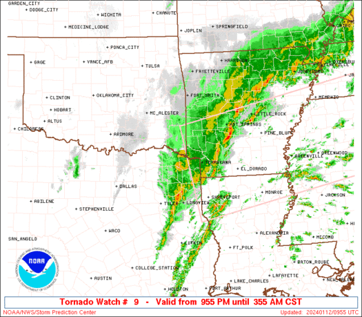
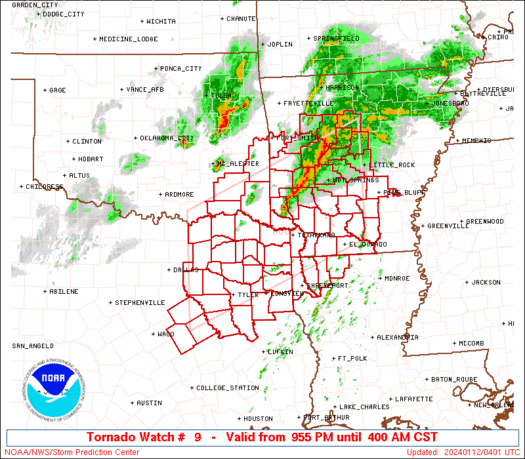
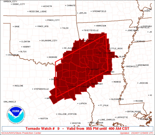
Tornado Watch Number 9
NWS Storm Prediction Center Norman OK
955 PM CST Thu Jan 11 2024
The NWS Storm Prediction Center has issued a
* Tornado Watch for portions of
parts of western and central Arkansas
northwestern Louisiana
southeastern Oklahoma
northeast Texas
* Effective this Thursday night and Friday morning from 955 PM
until 400 AM CST.
* Primary threats include...
A few tornadoes and a couple intense tornadoes possible
Scattered large hail and isolated very large hail events to 2
inches in diameter possible
Scattered damaging wind gusts to 70 mph possible
SUMMARY...Strong/locally severe thunderstorms have developed this
evening across the Arkansas vicinity, with additional storm
development expected over the next couple of hours along the cold
front, across northeastern Texas and spreading across the Arklatex
region overnight. The strongest storms across this region will be
capable of producing damaging wind gusts and large hail, with a
couple of tornadoes also possible.
The tornado watch area is approximately along and 80 statute miles
north and south of a line from 55 miles north of Corsicana TX to 45
miles east of Hot Springs AR. For a complete depiction of the watch
see the associated watch outline update (WOUS64 KWNS WOU9).
PRECAUTIONARY/PREPAREDNESS ACTIONS...
REMEMBER...A Tornado Watch means conditions are favorable for
tornadoes and severe thunderstorms in and close to the watch
area. Persons in these areas should be on the lookout for
threatening weather conditions and listen for later statements
and possible warnings.
&&
AVIATION...Tornadoes and a few severe thunderstorms with hail
surface and aloft to 2 inches. Extreme turbulence and surface wind
gusts to 60 knots. A few cumulonimbi with maximum tops to 400. Mean
storm motion vector 23040.
...Goss
   SEL9

   URGENT - IMMEDIATE BROADCAST REQUESTED
   Tornado Watch Number 9
   NWS Storm Prediction Center Norman OK
   955 PM CST Thu Jan 11 2024

   The NWS Storm Prediction Center has issued a

   * Tornado Watch for portions of
     parts of western and central Arkansas
     northwestern Louisiana
     southeastern Oklahoma
     northeast Texas

   * Effective this Thursday night and Friday morning from 955 PM
     until 400 AM CST.

   * Primary threats include...
     A few tornadoes and a couple intense tornadoes possible
     Scattered large hail and isolated very large hail events to 2
       inches in diameter possible
     Scattered damaging wind gusts to 70 mph possible

   SUMMARY...Strong/locally severe thunderstorms have developed this
   evening across the Arkansas vicinity, with additional storm
   development expected over the next couple of hours along the cold
   front, across northeastern Texas and spreading across the Arklatex
   region overnight.  The strongest storms across this region will be
   capable of producing damaging wind gusts and large hail, with a
   couple of tornadoes also possible.

   The tornado watch area is approximately along and 80 statute miles
   north and south of a line from 55 miles north of Corsicana TX to 45
   miles east of Hot Springs AR. For a complete depiction of the watch
   see the associated watch outline update (WOUS64 KWNS WOU9).

   PRECAUTIONARY/PREPAREDNESS ACTIONS...

   REMEMBER...A Tornado Watch means conditions are favorable for
   tornadoes and severe thunderstorms in and close to the watch
   area. Persons in these areas should be on the lookout for
   threatening weather conditions and listen for later statements
   and possible warnings.

   &&

   AVIATION...Tornadoes and a few severe thunderstorms with hail
   surface and aloft to 2 inches. Extreme turbulence and surface wind
   gusts to 60 knots. A few cumulonimbi with maximum tops to 400. Mean
   storm motion vector 23040.

   ...Goss
 Note:
The Aviation Watch (SAW) product is an approximation to the watch area.
The actual watch is depicted by the shaded areas.
Note:
The Aviation Watch (SAW) product is an approximation to the watch area.
The actual watch is depicted by the shaded areas.
   SAW9
   WW 9 TORNADO AR LA OK TX 120355Z - 121000Z
   AXIS..80 STATUTE MILES NORTH AND SOUTH OF LINE..
   55N CRS/CORSICANA TX/ - 45E HOT/HOT SPRINGS AR/
   ..AVIATION COORDS.. 70NM N/S /32E TTT - 14SSW LIT/
   HAIL SURFACE AND ALOFT..2 INCHES. WIND GUSTS..60 KNOTS.
   MAX TOPS TO 400. MEAN STORM MOTION VECTOR 23040.

   LAT...LON 33989640 35639231 33319231 31679640

   THIS IS AN APPROXIMATION TO THE WATCH AREA.  FOR A
   COMPLETE DEPICTION OF THE WATCH SEE WOUS64 KWNS
   FOR WOU9.
Watch 9 Status Report Messages:
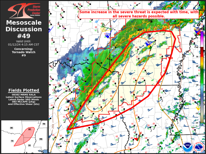
STATUS REPORT #3 ON WW 9

VALID 120850Z - 120940Z

SEVERE WEATHER THREAT CONTINUES RIGHT OF A LINE FROM 45 NNW CLL
TO 40 NNW TYR TO 40 ENE DEQ TO 30 SSW HRO.

FOR ADDITIONAL INFORMATION SEE MESOSCALE DISCUSSION 49

..DEAN..01/12/24

ATTN...WFO...LZK...SHV...TSA...FWD...

&&

STATUS REPORT FOR WT 9

SEVERE WEATHER THREAT CONTINUES FOR THE FOLLOWING AREAS

ARC011-013-019-023-025-027-029-039-045-051-053-057-059-061-069-
071-073-081-083-085-091-095-097-099-103-105-109-115-117-119-125-
133-139-141-145-147-149-120940-

AR
.    ARKANSAS COUNTIES INCLUDED ARE

BRADLEY 	     CALHOUN		 CLARK
CLEBURNE	     CLEVELAND		 COLUMBIA
CONWAY		     DALLAS		 FAULKNER
GARLAND 	     GRANT		 HEMPSTEAD
HOT SPRING	     HOWARD		 JEFFERSON
JOHNSON 	     LAFAYETTE		 LITTLE RIVER
LOGAN		     LONOKE		 MILLER
MONROE		     MONTGOMERY 	 NEVADA
OUACHITA	     PERRY		 PIKE
POPE		     PRAIRIE		 PULASKI
SALINE		     SEVIER		 UNION
VAN BUREN	     WHITE		 WOODRUFF
YELL
$$


LAC015-017-027-119-120940-

LA
.    LOUISIANA PARISHES INCLUDED ARE

BOSSIER 	     CADDO		 CLAIBORNE
WEBSTER
$$


TXC001-037-063-067-073-159-161-183-203-213-315-343-365-401-423-
449-459-499-120940-

TX
.    TEXAS COUNTIES INCLUDED ARE

ANDERSON	     BOWIE		 CAMP
CASS		     CHEROKEE		 FRANKLIN
FREESTONE	     GREGG		 HARRISON
HENDERSON	     MARION		 MORRIS
PANOLA		     RUSK		 SMITH
TITUS		     UPSHUR		 WOOD
$$


THE WATCH STATUS MESSAGE IS FOR GUIDANCE PURPOSES ONLY.  PLEASE
REFER TO WATCH COUNTY NOTIFICATION STATEMENTS FOR OFFICIAL
INFORMATION ON COUNTIES...INDEPENDENT CITIES AND MARINE ZONES
CLEARED FROM SEVERE THUNDERSTORM AND TORNADO WATCHES.
$$

STATUS REPORT #2 ON WW 9

VALID 120735Z - 120840Z

SEVERE WEATHER THREAT CONTINUES RIGHT OF A LINE FROM 15 ESE DAL
TO 15 ENE PRX TO 35 NNW DEQ TO 35 SE FYV.

..DEAN..01/12/24

ATTN...WFO...LZK...SHV...TSA...FWD...

&&

STATUS REPORT FOR WT 9

SEVERE WEATHER THREAT CONTINUES FOR THE FOLLOWING AREAS

ARC011-013-019-023-025-027-029-039-045-051-053-057-059-061-069-
071-073-081-083-085-091-095-097-099-103-105-109-113-115-117-119-
125-127-133-139-141-145-147-149-120840-

AR
.    ARKANSAS COUNTIES INCLUDED ARE

BRADLEY 	     CALHOUN		 CLARK
CLEBURNE	     CLEVELAND		 COLUMBIA
CONWAY		     DALLAS		 FAULKNER
GARLAND 	     GRANT		 HEMPSTEAD
HOT SPRING	     HOWARD		 JEFFERSON
JOHNSON 	     LAFAYETTE		 LITTLE RIVER
LOGAN		     LONOKE		 MILLER
MONROE		     MONTGOMERY 	 NEVADA
OUACHITA	     PERRY		 PIKE
POLK		     POPE		 PRAIRIE
PULASKI 	     SALINE		 SCOTT
SEVIER		     UNION		 VAN BUREN
WHITE		     WOODRUFF		 YELL
$$


LAC015-017-027-119-120840-

LA
.    LOUISIANA PARISHES INCLUDED ARE

BOSSIER 	     CADDO		 CLAIBORNE
WEBSTER
$$


OKC089-120840-

OK
.    OKLAHOMA COUNTIES INCLUDED ARE

MCCURTAIN
$$


TXC001-037-063-067-073-159-161-183-203-213-223-257-293-315-343-
349-365-379-387-401-423-449-459-467-499-120840-

TX
.    TEXAS COUNTIES INCLUDED ARE

ANDERSON	     BOWIE		 CAMP
CASS		     CHEROKEE		 FRANKLIN
FREESTONE	     GREGG		 HARRISON
HENDERSON	     HOPKINS		 KAUFMAN
LIMESTONE	     MARION		 MORRIS
NAVARRO 	     PANOLA		 RAINS
RED RIVER	     RUSK		 SMITH
TITUS		     UPSHUR		 VAN ZANDT
WOOD
$$


THE WATCH STATUS MESSAGE IS FOR GUIDANCE PURPOSES ONLY.  PLEASE
REFER TO WATCH COUNTY NOTIFICATION STATEMENTS FOR OFFICIAL
INFORMATION ON COUNTIES...INDEPENDENT CITIES AND MARINE ZONES
CLEARED FROM SEVERE THUNDERSTORM AND TORNADO WATCHES.
$$

STATUS REPORT #1 ON WW 9

VALID 120640Z - 120740Z

THE SEVERE WEATHER THREAT CONTINUES ACROSS THE ENTIRE WATCH AREA.

FOR ADDITIONAL INFORMATION SEE MESOSCALE DISCUSSION 47

..DEAN..01/12/24

ATTN...WFO...LZK...SHV...TSA...FWD...

&&

STATUS REPORT FOR WT 9

SEVERE WEATHER THREAT CONTINUES FOR THE FOLLOWING AREAS

ARC011-013-019-023-025-027-029-039-045-051-053-057-059-061-069-
071-073-081-083-085-091-095-097-099-103-105-109-113-115-117-119-
125-127-131-133-139-141-145-147-149-120740-

AR
.    ARKANSAS COUNTIES INCLUDED ARE

BRADLEY 	     CALHOUN		 CLARK
CLEBURNE	     CLEVELAND		 COLUMBIA
CONWAY		     DALLAS		 FAULKNER
GARLAND 	     GRANT		 HEMPSTEAD
HOT SPRING	     HOWARD		 JEFFERSON
JOHNSON 	     LAFAYETTE		 LITTLE RIVER
LOGAN		     LONOKE		 MILLER
MONROE		     MONTGOMERY 	 NEVADA
OUACHITA	     PERRY		 PIKE
POLK		     POPE		 PRAIRIE
PULASKI 	     SALINE		 SCOTT
SEBASTIAN	     SEVIER		 UNION
VAN BUREN	     WHITE		 WOODRUFF
YELL
$$


LAC015-017-027-119-120740-

LA
.    LOUISIANA PARISHES INCLUDED ARE

BOSSIER 	     CADDO		 CLAIBORNE
WEBSTER
$$


OKC023-079-089-127-120740-

OK
.    OKLAHOMA COUNTIES INCLUDED ARE

CHOCTAW 	     LE FLORE		 MCCURTAIN
PUSHMATAHA
$$


TXC001-037-063-067-073-119-147-159-161-183-203-213-223-231-257-
277-293-315-343-349-365-379-387-397-401-423-449-459-467-499-
120740-

TX
.    TEXAS COUNTIES INCLUDED ARE

ANDERSON	     BOWIE		 CAMP
CASS		     CHEROKEE		 DELTA
FANNIN		     FRANKLIN		 FREESTONE
GREGG		     HARRISON		 HENDERSON
HOPKINS 	     HUNT		 KAUFMAN
LAMAR		     LIMESTONE		 MARION
MORRIS		     NAVARRO		 PANOLA
RAINS		     RED RIVER		 ROCKWALL
RUSK		     SMITH		 TITUS
UPSHUR		     VAN ZANDT		 WOOD
$$


THE WATCH STATUS MESSAGE IS FOR GUIDANCE PURPOSES ONLY.  PLEASE
REFER TO WATCH COUNTY NOTIFICATION STATEMENTS FOR OFFICIAL
INFORMATION ON COUNTIES...INDEPENDENT CITIES AND MARINE ZONES
CLEARED FROM SEVERE THUNDERSTORM AND TORNADO WATCHES.
$$
Note:
Click for Complete Product Text.
Tornadoes
Probability of 2 or more tornadoes
|
Mod (50%)
|
Probability of 1 or more strong (EF2-EF5) tornadoes
|
Mod (40%)
|
Wind
Probability of 10 or more severe wind events
|
Mod (50%)
|
Probability of 1 or more wind events > 65 knots
|
Low (20%)
|
Hail
Probability of 10 or more severe hail events
|
Mod (40%)
|
Probability of 1 or more hailstones > 2 inches
|
Mod (40%)
|
Combined Severe Hail/Wind
Probability of 6 or more combined severe hail/wind events
|
High (70%)
|
For each watch, probabilities for particular events inside the watch
(listed above in each table) are determined by the issuing forecaster.
The "Low" category contains probability values ranging from less than 2%
to 20% (EF2-EF5 tornadoes), less than 5% to 20% (all other probabilities),
"Moderate" from 30% to 60%, and "High" from 70% to greater than 95%.
High values are bolded and lighter in color to provide awareness of
an increased threat for a particular event.


 @NWSSPC