|
| Mesoscale Discussion 51 |
|
< Previous MD Next MD >
|
|
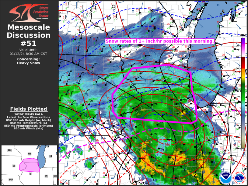
   Mesoscale Discussion 0051
   NWS Storm Prediction Center Norman OK
   0423 AM CST Fri Jan 12 2024

   Areas affected...Northern IL...Southern WI...Eastern IA

   Concerning...Heavy snow

   Valid 121023Z - 121430Z

   SUMMARY...Snow rates of 1+ inch per hour will spread northward this
   morning.

   DISCUSSION...At 1015 UTC, a broad region of moderate precipitation
   is ongoing within the warm conveyor belt of a deepening cyclone
   currently centered near the Ozark Plateau. Within this region, an
   area of locally heavier precipitation is noted from eastern IA into
   northern IL, where some enhancement is likely being provided by a
   midlevel shortwave trough that is moving across southern IL in
   advance of the primary shortwave across the central/southern Plains.

   Some increase in moderate to heavy snow observations has been noted
   over the last hour across northwest/north-central IL, and this trend
   is likely to continue as heavier precipitation spreads into
   northeast IL and southern WI. Favorable moistening and ascent within
   a deep layer (including the dendritic growth zone) will support snow
   rates of 1+ inch per hour for at least a few hours this morning.

   Continued strong low-level warm advection will eventually result in
   a snow-to-rain transition along the southern periphery of the
   ongoing precipitation shield, with the rain/snow line expected to
   gradually advance northward into parts of northern IL later this
   morning.

   ..Dean.. 01/12/2024

   ...Please see www.spc.noaa.gov for graphic product...

   ATTN...WFO...LOT...ILX...MKX...DVN...ARX...

   LAT...LON   42928774 42298769 41908757 41638752 41418749 41158750
               41068777 41168948 41229053 41269132 41499156 42109160
               43069064 43208884 42928774
|
|
Top/All Mesoscale Discussions/Forecast Products/Home
|
|


 @NWSSPC