|
| Mesoscale Discussion 1620 |
|
< Previous MD Next MD >
|
|
Mesoscale Discussion 1620
NWS Storm Prediction Center Norman OK
0740 PM CDT Sun Jul 14 2024
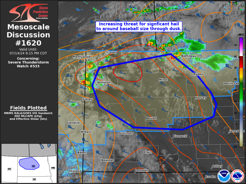
Areas affected...parts of western/central ND
Concerning...Severe Thunderstorm Watch 533...
Valid 150040Z - 150215Z
The severe weather threat for Severe Thunderstorm Watch 533
continues.
SUMMARY...An increasing threat for significant severe hail from 2-3
inches in diameter should exist through about 10 PM CDT across parts
of western to central North Dakota.
DISCUSSION...Two areas of ongoing convection should intensify during
the next couple hours across parts of western and central ND. One
corridor is favored across north-central ND where an arc of
supercells are ongoing along and behind a southward-sagging front
that is being augmented by leading convective outflow. Higher-based
cells along the ND/MT border area have been slower to intensify, but
should do so as they ingest an increasingly buoyant air mass
downstream in northwest ND. MBX VWP data has sampled robust mid to
upper-level speed shear above 700 mb and confirmed by the 00Z BIS
sounding, yielding effective bulk values around 50 kts. This type of
wind profile with substantial straight-line elongation will support
splitting, discrete supercells and potential for significant severe
hail as activity spreads southeastward this evening.
..Grams.. 07/15/2024
...Please see www.spc.noaa.gov for graphic product...
ATTN...WFO...FGF...BIS...
LAT...LON 48930082 48409984 47929931 47649912 47339924 47020040
47070222 47610348 48110378 48570353 48930082
|
|
Top/All Mesoscale Discussions/Forecast Products/Home
|
|


 @NWSSPC