|
| Mesoscale Discussion 1616 |
|
< Previous MD Next MD >
|
|
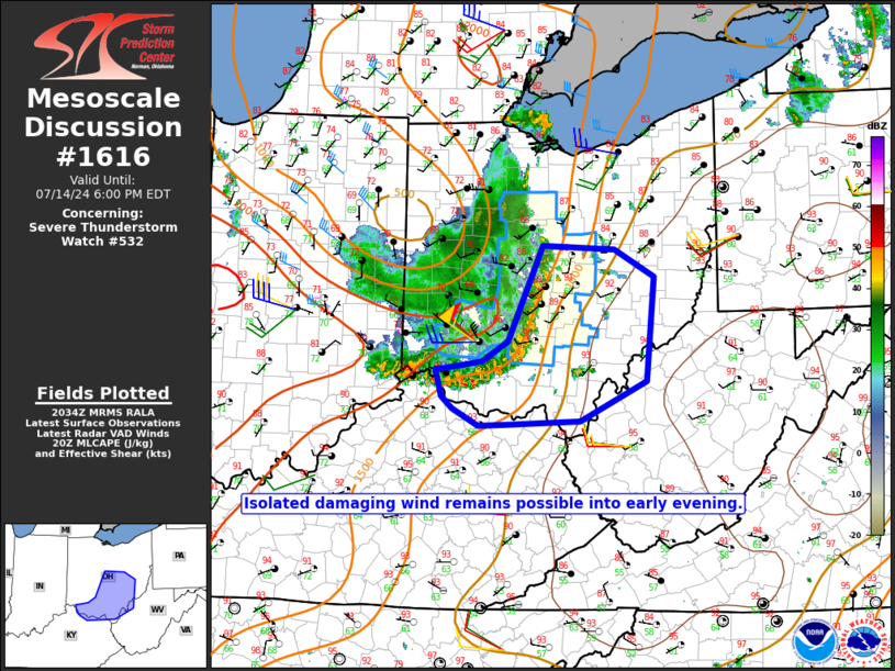
   Mesoscale Discussion 1616
   NWS Storm Prediction Center Norman OK
   0337 PM CDT Sun Jul 14 2024

   Areas affected...Parts of southern/central OH into northern KY and
   western WV

   Concerning...Severe Thunderstorm Watch 532...

   Valid 142037Z - 142200Z

   The severe weather threat for Severe Thunderstorm Watch 532
   continues.

   SUMMARY...Isolated damaging to severe wind gusts remain possible
   into early evening.

   DISCUSSION...An MCS moving across southwest OH has recently produced
   a 51 kt measured gust at KDAY and 57 kt at KILN. The immediate
   downstream thermodynamic environment remains somewhat favorable,
   with steep low-level lapse rates and MLCAPE of 1000-1500 J/kg, so
   potentially damaging wind gusts of 50-65 mph will remain possible
   through late afternoon.

   Farther downstream, instability weakens within a drier environment
   across southeast OH into western WV. With some warming of cloud tops
   already noted on IR imagery, gradual weakening of this MCS seems
   likely with time into the evening. With the remaining threat
   potentially becoming rather isolated and confined in areal extent,
   downstream watch issuance is considered unlikely at this time.
   However, some threat for isolated damaging wind may persist into
   parts of southeast OH and extreme western WV into early evening.

   ..Dean/Hart.. 07/14/2024

   ...Please see www.spc.noaa.gov for graphic product...

   ATTN...WFO...PBZ...RLX...CLE...ILN...

   LAT...LON   40438290 40388193 40098139 38998150 38588240 38548345
               38538378 38708412 38848428 39118436 39168404 39208373
               39418337 40438290
|
|
Top/All Mesoscale Discussions/Forecast Products/Home
|
|


 @NWSSPC