Mesoscale Discussion 1615
NWS Storm Prediction Center Norman OK
0315 PM CDT Sun Jul 14 2024
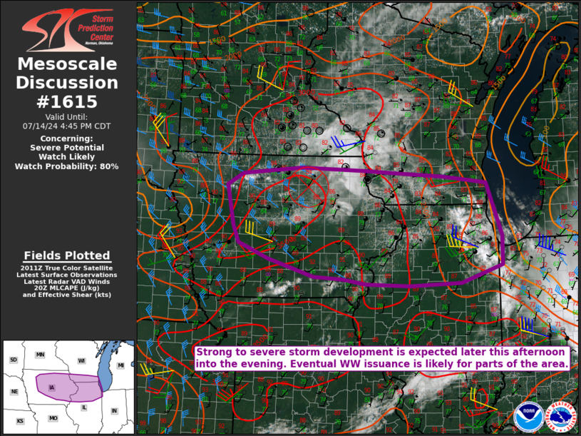
Areas affected...Parts of IA...northern IL...southern WI
Concerning...Severe potential...Watch likely
Valid 142015Z - 142145Z
Probability of Watch Issuance...80 percent
SUMMARY...Strong to severe storm development is expected later this
afternoon into the evening. Eventual watch issuance is likely.
DISCUSSION...Rather strong heating/destabilization is underway
across much of IA this afternoon, while recovery in the wake of
morning convection/outflow is ongoing across northern IL. Meanwhile,
the remnant MCV from last night's severe MCS over the Dakotas is
currently moving across northern IA. As MLCINH continues to erode
across northern/eastern IA and MLCAPE increases above 3000 J/kg, the
MCV may aid in scattered thunderstorm development later this
afternoon. Midlevel flow is not particularly strong across the
region, but sufficient to support effective shear of 25-35 kt and
potential for some storm organization.
Initial discrete development could evolve into a supercell or two,
with a threat of hail, locally damaging wind, and possibly a
tornado. In conjunction with the MCV, a persistent 20-30 kt
southwesterly low-level jet could encourage relatively quick
clustering and upscale growth, with some potential for an MCS to
develop and move eastward across northern IL and southern WI this
evening, with a continued severe-wind threat.
Farther northwest, in the wake of the MCV, cumulus is deepening
along a weak surface boundary across northwest IA. While this area
is in the immediate wake of the MCV, strong buoyancy and sufficient
deep-layer shear would support severe-thunderstorm potential in this
area as well, if storms can mature.
While favored timing and area remain somewhat uncertain, watch
issuance will become increasingly likely if storm initiation appears
imminent across the region.
..Dean/Hart.. 07/14/2024
...Please see www.spc.noaa.gov for graphic product...
ATTN...WFO...LOT...ILX...MKX...DVN...ARX...DMX...FSD...
LAT...LON 41389383 41709465 42059481 42449490 42889500 43119456
43259293 43209113 43169047 43068900 42938781 41838741
41238742 40888855 40838996 40879116 40969178 41019259
41389383
|


 @NWSSPC