|
| Mesoscale Discussion 1617 |
|
< Previous MD Next MD >
|
|
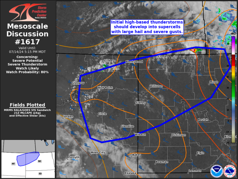
   Mesoscale Discussion 1617
   NWS Storm Prediction Center Norman OK
   0438 PM CDT Sun Jul 14 2024

   Areas affected...northeast MT and northwest to far north-central ND

   Concerning...Severe potential...Severe Thunderstorm Watch likely

   Valid 142138Z - 142315Z

   Probability of Watch Issuance...80 percent

   SUMMARY...Initial high-based thunderstorms over northeast Montana
   should develop into supercells with threats for large hail and
   isolated severe gusts during the early evening. A severe
   thunderstorm watch issuance is likely by 22Z.

   DISCUSSION...Increasingly agitated cumulus is noted near a 1008 mb
   surface cyclone in the Glasgow vicinity. This corridor is likely to
   initiate into several thunderstorms during the next couple hours as
   large-scale ascent increases downstream of a shortwave trough
   digging over southern AB into SK. Warm-moist sector temperature/dew
   point spreads of 40-45 F suggest the environment is uncapped and
   deeply mixed. The 19Z BIS sounding sampled ample speed shear above
   700 mb within a west-northwest mid/upper flow regime which will
   favor high-based supercell development. Initial storms should
   produce a mix of large hail and severe gusts. Downstream
   intensification and potentially more widespread coverage is
   anticipated deeper into the evening as cells impinge on the more air
   mass, characterized by mid 60s surface dew points roughly along and
   east of the Lake Sakakawea region of the MO River. An isolated large
   hail threat may also exist with warm-advection storms along the
   surface warm front farther east near the international border of
   northwest to north-central ND.

   ..Grams/Gleason.. 07/14/2024

   ...Please see www.spc.noaa.gov for graphic product...

   ATTN...WFO...BIS...BYZ...GGW...

   LAT...LON   48440628 48890416 49180178 49120065 48650043 47880123
               47170321 46840447 46720541 46820583 47830633 48440628
|
|
Top/All Mesoscale Discussions/Forecast Products/Home
|
|


 @NWSSPC