|
| Mesoscale Discussion 1595 |
|
< Previous MD Next MD >
|
|
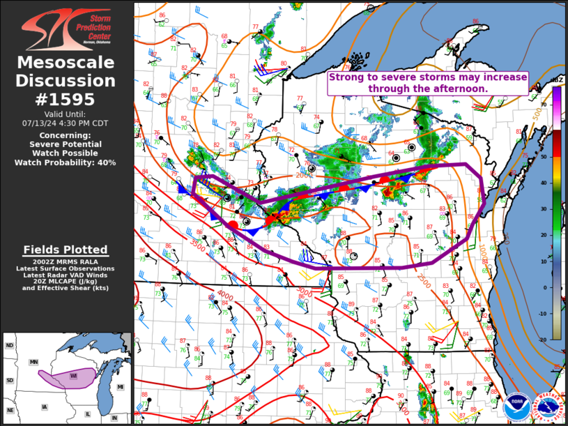
   Mesoscale Discussion 1595
   NWS Storm Prediction Center Norman OK
   0304 PM CDT Sat Jul 13 2024

   Areas affected...Southeast MN into central WI

   Concerning...Severe potential...Watch possible

   Valid 132004Z - 132130Z

   Probability of Watch Issuance...40 percent

   SUMMARY...Strong to severe storms may increase through the
   afternoon, with a threat of isolated hail, damaging wind, and
   possibly a brief tornado.

   DISCUSSION...Some recent intensification has been noted with storms
   across central WI, and also near the MN/WI to the southeast of the
   Twin Cities. Both of these storm clusters are located near an
   outflow-influenced front, with very warm and moist conditions noted
   south of the effective front across southeast MN and central WI.

   Convective evolution through the afternoon remains somewhat
   uncertain, but some increase in storm coverage and intensity will be
   possible as MLCAPE continues to increase into the 2000-3000 J/kg
   along/south of the boundary. Effective shear generally ranges from
   25-35 kt (greater with westward extent), with some modest increase
   possible as somewhat stronger midlevel flow overspreads the region
   through the afternoon. A few stronger clusters and possibly a couple
   of supercells could evolve with time. Large hail and locally
   damaging wind would be the most likely hazards, though a brief
   tornado cannot be ruled out near the boundary.

   Watch issuance is possible if observational trends continue to
   support an increase in storm coverage through the afternoon.

   ..Dean/Hart.. 07/13/2024

   ...Please see www.spc.noaa.gov for graphic product...

   ATTN...WFO...GRB...MKX...ARX...MPX...

   LAT...LON   43879201 44049261 44389340 44889418 45139414 45169377
               44779273 45189028 45348911 45358831 45138798 44748792
               44448818 44218832 43858906 43798971 43789154 43879201
|
|
Top/All Mesoscale Discussions/Forecast Products/Home
|
|


 @NWSSPC