|
| Mesoscale Discussion 1594 |
|
< Previous MD Next MD >
|
|
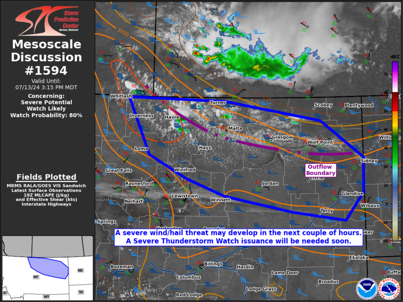
   Mesoscale Discussion 1594
   NWS Storm Prediction Center Norman OK
   0244 PM CDT Sat Jul 13 2024

   Areas affected...northern into eastern Montana

   Concerning...Severe potential...Watch likely

   Valid 131944Z - 132115Z

   Probability of Watch Issuance...80 percent

   SUMMARY...The severe threat is increasing across portions of
   northern into eastern Montana this afternoon. Severe wind and hail
   are the main threats. A WW issuance is likely within the next hour
   or so to address the impending severe threat.

   DISCUSSION...Remnant convection across southwestern MB (Canada) has
   produced an outflow boundary that is currently situated from roughly
   the SK/MB/MT border to Richland County, MT. The boundary layer
   continues to destabilize along this outflow boundary, where visible
   satellite shows rapidly deepening CU, and MRMS mosaic radar imagery
   showing the first signs of convective initiation. 19Z mesoanalysis
   shows a 500 mb speed max with small embedded vort maxima pivoting
   around the northern periphery of an anticyclone centered over the
   central Rockies, which will also provide enough lift for
   thunderstorm development. Along the outflow boundary, upslope flow
   is contributing to low-level southeasterly winds beneath stronger
   westerly mid-level flow (driven by the approaching 500 mb speed
   max), resulting in 50+ kts of effective bulk shear in the form of
   elongated, straight hodographs. With upper 50s/low 60s F surface
   dewpoints beneath 7-8 C/km mid-level lapse rates also supporting
   2000 J/kg MLCAPE, supercell storm modes are favored early on. Severe
   wind and hail will be possible (and an instance of 2+ inch diameter
   hail cannot be ruled out).

   Some high-resolution convection-allowing guidance shows
   thunderstorms growing upscale into a bow echo MCS, and this scenario
   is plausible given the potential for adequate evaporative cooling
   within a well-mixed boundary layer. Should this occur, a focused
   corridor of severe winds could develop later this afternoon. A
   Severe Thunderstorm Watch will be needed within the next hour or so.

   ..Squitieri/Hart.. 07/13/2024

   ...Please see www.spc.noaa.gov for graphic product...

   ATTN...WFO...BYZ...GGW...TFX...

   LAT...LON   48981067 48930793 48560523 47850404 47180406 46660458
               46840610 47130794 47470902 47891006 48981067
|
|
Top/All Mesoscale Discussions/Forecast Products/Home
|
|


 @NWSSPC