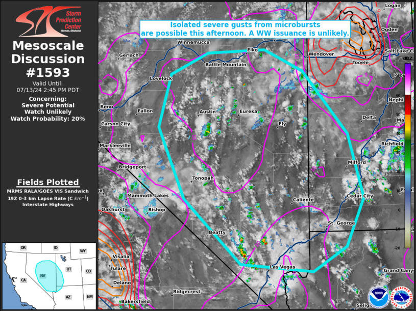
   Mesoscale Discussion 1593
   NWS Storm Prediction Center Norman OK
   0220 PM CDT Sat Jul 13 2024

   Areas affected...much of central and southern Nevada into far
   southwestern Utah and extreme northwestern Arizona

   Concerning...Severe potential...Watch unlikely

   Valid 131920Z - 132145Z

   Probability of Watch Issuance...20 percent

   SUMMARY...Isolated severe gusts may accompany potential microbursts
   with the stronger storms today. A WW issuance is not expected.

   DISCUSSION...Agitated cumulus, with a few attempts at convective
   initiation, have been noted over the past couple of hours based on
   MRMS mosaic radar imagery, visible satellite, and NLDN lightning
   data. The boundary layer has become deep and well mixed, with 19Z
   mesoanalysis showing 9-11 C/km 0-3 km lapse rates already in place,
   and RAP forecast soundings depicting inverted-v profiles extending
   to 600 mb. Mid-level monsoonal moisture overspreading the mixed
   boundary layer/steep lapse rates will promote 250-500 J/kg
   SBCAPE/MLCAPE through the afternoon, which is more than sufficient
   to support thunderstorm updrafts. Vertical wind shear should be
   weak, so thunderstorms should be pulse-cellular in nature, with any
   severe gusts originating from localized, short-lived microbursts.
   Despite the severe gust potential, the coverage of the severe should
   be sparse enough to preclude a WW issuance.

   ..Squitieri/Hart.. 07/13/2024

   ...Please see www.spc.noaa.gov for graphic product...

   ATTN...WFO...SLC...VEF...LKN...REV...

   LAT...LON   36291587 37691742 39221815 40351784 40831681 40911525
               40441418 39091296 37701256 36661304 36141394 36291587
|


 @NWSSPC