|
| Mesoscale Discussion 1587 |
|
< Previous MD Next MD >
|
|
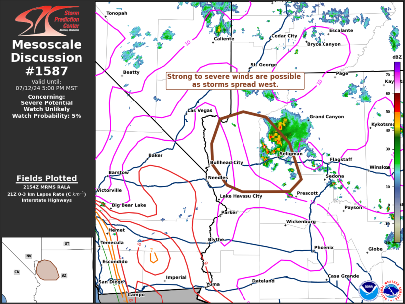
   Mesoscale Discussion 1587
   NWS Storm Prediction Center Norman OK
   0457 PM CDT Fri Jul 12 2024

   Areas affected...Western Arizona

   Concerning...Severe potential...Watch unlikely

   Valid 122157Z - 130000Z

   Probability of Watch Issuance...5 percent

   SUMMARY...A cluster of thunderstorms spreading west across
   west/northwest Arizona may produce strong to severe winds over the
   next couple of hours. Watch issuance is not anticipated given the
   limited spatial extent of the threat and marginal environmental
   conditions.

   DISCUSSION...Latest radar imagery from KESX shows a growing cluster
   of thunderstorms across west/northwest AZ that appears to be
   gradually intensifying as it grows upscale based on GOES IR imagery
   and lightning trends. Velocity data suggest that cold pool
   amalgamation is underway, with a more cohesive cluster/linear
   segment likely to emerge across western AZ in the next 1-2 hours.
   Very hot (100+ F) conditions downstream are supporting dewpoint
   depressions above 50 F, suggesting a very deeply mixed boundary
   layer is in place. These low-level thermodynamic conditions are
   favorable for strong to severe downburst winds within the
   cluster/segment. Although slightly better buoyancy is also noted
   downstream towards the CO River, increasing MLCIN with westward
   extent may modulate the overall intensity and longevity of this
   threat, resulting in a somewhat narrow corridor of an appreciable
   severe threat.

   ..Moore/Gleason.. 07/12/2024

   ...Please see www.spc.noaa.gov for graphic product...

   ATTN...WFO...FGZ...VEF...

   LAT...LON   35591260 34881232 34641261 34631375 34771413 35161448
               35591451 36081430 36221373 36121317 35591260
|
|
Top/All Mesoscale Discussions/Forecast Products/Home
|
|


 @NWSSPC