|
| Mesoscale Discussion 1585 |
|
< Previous MD Next MD >
|
|
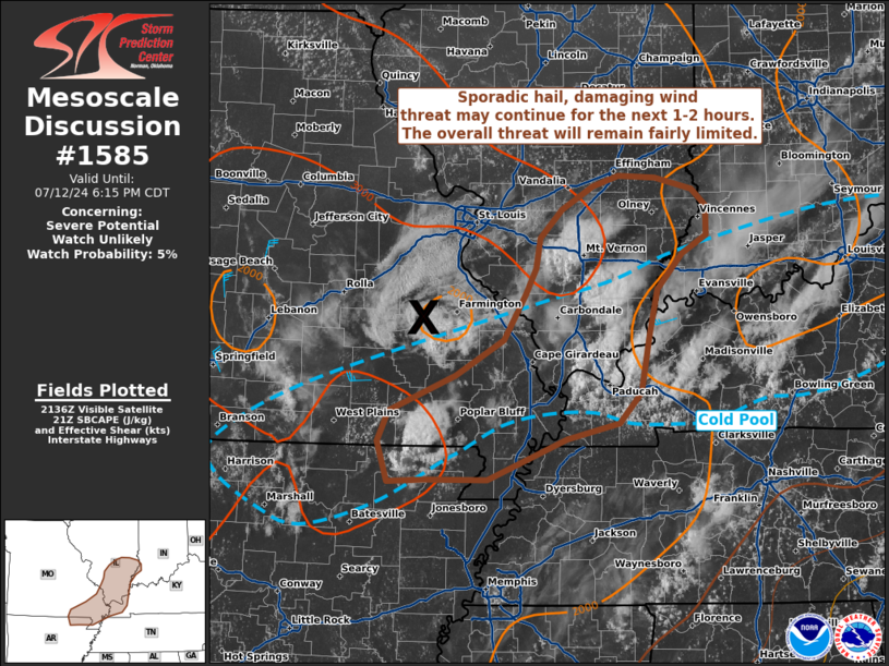
   Mesoscale Discussion 1585
   NWS Storm Prediction Center Norman OK
   0440 PM CDT Fri Jul 12 2024

   Areas affected...Far northeast Arkansas into southern Illinois and
   far southwest Indiana

   Concerning...Severe potential...Watch unlikely

   Valid 122140Z - 122315Z

   Probability of Watch Issuance...5 percent

   SUMMARY...A localized threat for isolated hail and damaging winds
   may continue for the next 1-2 hours across far northeast Arkansas
   into southern Illinois and far southwest Indiana. In general, the
   severe threat is expected to wane heading into the evening hours.

   DISCUSSION...Regional radar composites and GOES visible imagery show
   a clear convective cold pool expanding across the lower OH River
   Valley region with convection largely struggling to remain sustained
   (largely owing to weak environmental shear and storm motions into
   the cold pool). However, over the past 30 minutes, a couple of
   brief, but relatively intense updrafts have been noted in IR
   cloud-top temperatures. MRMS hail metrics suggest hail may be
   approaching severe limits, and the overall thermodynamic environment
   on the periphery of the cold pool (characterized by over 2000 J/kg
   MLCAPE and somewhat steep lapse rates in the lowest 1-2 km) may
   support damaging downburst winds. Ambient lift along the outflow
   boundary and ahead of a weak MCV over southeast MO may support
   additional convection over the next 1-2 hours, but storm longevity
   (and the overall severe threat) is expected to remain fairly
   limited.

   ..Moore/Gleason.. 07/12/2024

   ...Please see www.spc.noaa.gov for graphic product...

   ATTN...WFO...IND...PAH...ILX...MEG...LSX...LZK...SGF...

   LAT...LON   38508743 38328771 37998802 37548811 37008821 36728848
               36568909 36179004 36179077 36169121 36539134 36839120
               37179041 37518984 37948958 38188946 38488942 38748915
               38978878 39068847 39058804 38948760 38788743 38508743
|
|
Top/All Mesoscale Discussions/Forecast Products/Home
|
|


 @NWSSPC