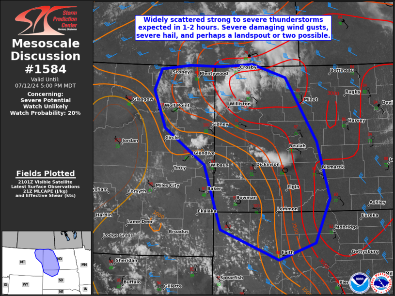
   Mesoscale Discussion 1584
   NWS Storm Prediction Center Norman OK
   0405 PM CDT Fri Jul 12 2024

   Areas affected...Far northeastern Montana...western North
   Dakota...and far northwestern South Dakota

   Concerning...Severe potential...Watch unlikely

   Valid 122105Z - 122300Z

   CORRECTED FOR GRAPHIC

   Probability of Watch Issuance...20 percent

   SUMMARY...Widely scattered thunderstorms are expected to develop
   over the next 1-2 hours across portions of western ND, far
   northeastern MT, and far northwestern SD. Severe wind gusts near
   65-76 mph, hail up to 1.5-2.0" in diameter, and perhaps a landspout
   tornado or two will be possible with the stronger thunderstorms.

   DISCUSSION...Diurnal heating across the northern plains has resulted
   in very warm temperatures in the low to upper 90s developing this
   afternoon. This, combined with surface dewpoints in the low 70s east
   of a surface trough/quasi-stationary warm front below steep
   mid-level lapse rates, is yielding 1500-3000 J/kg of MLCAPE. Recent
   satellite imagery shows increasing cumulus beginning to develop
   along the aforementioned trough. In addition, convective initiation
   has already taken place near Manning, ND. Increasing mid-level flow
   throughout late this afternoon into early this evening will likely
   support some thunderstorm organization and the potential for a few
   supercells.

   Thunderstorm coverage is expected to slowly increase late this
   afternoon, as destabilization continues under cooler temperatures
   aloft, subtle DCVA impacts the area, and surface convergence is
   enhanced. Considering large dewpoint-temperature spreads further
   west near the MT/ND border, damaging wind gusts appear more likely
   there, although a few instances of large hail cannot be ruled out
   through early this evening. Increasing low level helicity via backed
   surface flow with time, along with some enhanced stretching, could
   also support a landspout or two before sunset. Although a watch does
   not appear likely at this time due to an uncertainty in severe
   thunderstorm coverage, convective trends will be monitored closely
   over the next 1-2 hours.

   ..Barnes/Hart.. 07/12/2024

   ...Please see www.spc.noaa.gov for graphic product...

   ATTN...WFO...ABR...BIS...UNR...BYZ...GGW...

   LAT...LON   46920434 47680556 48480593 48910571 49010481 48990386
               49040286 48760183 47400088 46220052 45280096 44920207
               45570383 46920434
|


 @NWSSPC