|
| Mesoscale Discussion 1582 |
|
< Previous MD Next MD >
|
|
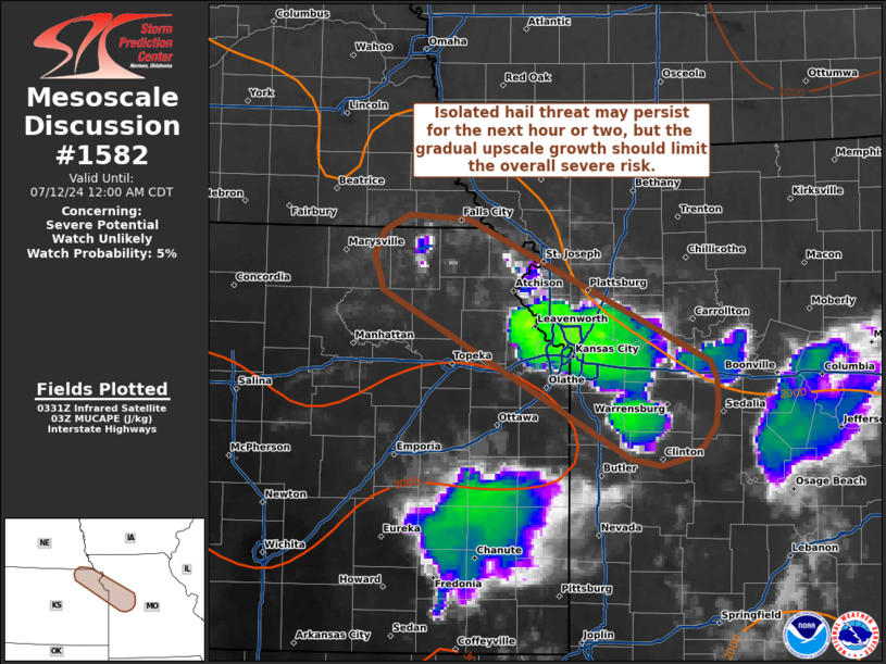
   Mesoscale Discussion 1582
   NWS Storm Prediction Center Norman OK
   1036 PM CDT Thu Jul 11 2024

   Areas affected...Northeast Kansas to northwest Missouri

   Concerning...Severe potential...Watch unlikely

   Valid 120336Z - 120500Z

   Probability of Watch Issuance...5 percent

   SUMMARY...An isolated severe hail risk may persist across northwest
   Missouri into northeast Kansas for the next 1-2 hours; however,
   long-term trends should favor destructive storm interactions and an
   overall weakening trend. Watch issuance is not expected.

   DISCUSSION...Ongoing thunderstorms across the broader Kansas City
   region have had a history of producing severe hail (up to 1.75
   inches) over roughly the past hour. While individual storm longevity
   has been fairly limited, deep convection continues to develop along
   the south/southwestern flank of the convective outflow.
   Additionally, new convective towers are noted to the northwest into
   northeast KS as a weak mid-level perturbation pivots into the
   region. Modest deep-layer shear (around 25-30 knots) is expected to
   continue to limit storm longevity/organization, and storm
   motions/propagation to the south/southeast along the developing
   initiation axis should favor upscale growth and destructive storm
   interactions with time. However, prior to upscale growth more
   discrete, intense updraft pulses may realize the moderately unstable
   air mass (2000-2500 J/kg MLCAPE based on the 00Z TOP sounding and
   recent RAP mesoanalysis estimates) and continue to support a
   sporadic severe hail threat within a narrow corridor from northeast
   KS to northwest MO.

   ..Moore/Gleason.. 07/12/2024

   ...Please see www.spc.noaa.gov for graphic product...

   ATTN...WFO...EAX...OAX...TOP...

   LAT...LON   38449413 38919508 39259583 39569630 39819638 39989629
               40089607 40059552 39779476 39439407 39179378 38939364
               38729361 38569363 38489369 38429379 38409386 38449413
|
|
Top/All Mesoscale Discussions/Forecast Products/Home
|
|


 @NWSSPC