|
| Mesoscale Discussion 1581 |
|
< Previous MD Next MD >
|
|
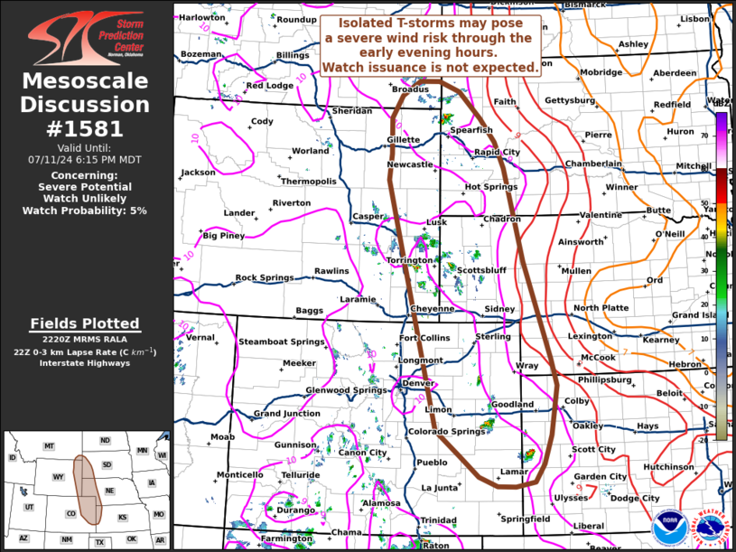
   Mesoscale Discussion 1581
   NWS Storm Prediction Center Norman OK
   0522 PM CDT Thu Jul 11 2024

   Areas affected...Portions of the central High Plains

   Concerning...Severe potential...Watch unlikely

   Valid 112222Z - 120015Z

   Probability of Watch Issuance...5 percent

   SUMMARY...Isolated to scattered thunderstorms developing across the
   central High Plains may pose an isolated severe wind and hail risk
   through the early evening hours. This threat should remain fairly
   localized/limited; watch issuance is not expected.

   DISCUSSION...Over the past 1-2 hours, isolated to scattered
   high-based thunderstorms have developing along and west of a lee
   surface trough within a deeply mixed, but marginally buoyant air
   mass. More recently, thunderstorm longevity has been relatively
   short lived (around 30-60 minutes) based on radar and GOES
   IR/cloud-top temperature trends. This is attributable to somewhat
   meager buoyancy profiles on the periphery of deeper/higher-quality
   moisture to the east across the Plains. Dewpoint depressions near 40
   F and low-level lapse rates near 9 C/km also suggest a very deeply
   mixed boundary layer is in place, which will favor rapid
   undercutting outflows given poor low-level storm-relative winds.
   Thunderstorm coverage may remain limited to near/along the surface
   trough axis given increasing MLCIN with eastward extent and
   south/southeasterly storm motions. A few more organized cells are
   possible given 30-40 knots of effective bulk shear, but the general
   expectation for the next few hours is for isolated to scattered
   thunderstorms to primarily pose a severe wind threat given the
   favorable low-level thermodynamics for strong convective outflow.

   ..Moore/Gleason.. 07/11/2024

   ...Please see www.spc.noaa.gov for graphic product...

   ATTN...WFO...LBF...DDC...UNR...GLD...PUB...BOU...CYS...BYZ...

   LAT...LON   37920263 38090307 38490354 38960412 43660535 44140529
               44820530 45230503 45500459 45500409 45320356 44820302
               44370266 43890242 42130195 40310130 39800117 38880131
               38330150 38000172 37910218 37920263
|
|
Top/All Mesoscale Discussions/Forecast Products/Home
|
|


 @NWSSPC