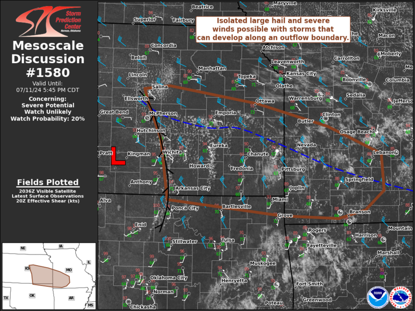
   Mesoscale Discussion 1580
   NWS Storm Prediction Center Norman OK
   0344 PM CDT Thu Jul 11 2024

   Areas affected...Southeastern Kansas into southwest Missouri

   Concerning...Severe potential...Watch unlikely

   Valid 112044Z - 112245Z

   Probability of Watch Issuance...20 percent

   SUMMARY...Isolated large hail and severe gusts will be the primary
   threats with storms that can develop along an outflow boundary. A
   watch is not anticipated this afternoon.

   DISCUSSION...Convection from last evening into this morning left an
   outflow boundary across parts of southeast Kansas into southwest
   Missouri. A subtle surface low is also evident just east of Pratt,
   KS in surface observations. Convergence along this boundary has
   promoted modestly deepening cumulus over the last few hours. Of
   particular note are more agitated cumulus from near Emporia, KS to
   south of Eureka, KS. Additional towers are developing northwest of
   Springfield, MO. The exact area of where strong/severe storms will
   develop is not certain. CAM guidance has generally suggested robust
   storm initiation will occur by late afternoon; however, with greater
   low-level moisture near the boundary than forecast in models, this
   may occur sooner than anticipated.

   With weak upper-level support, storm coverage should remain
   isolated. Strong buoyancy (2000+ J/kg MLCAPE), effective shear of
   25-30 kts, and steep mid-level lapse rates will promote a risk of
   large hail and severe wind gusts. With temperature-dewpoint spreads
   nearing 30 F (primarily in southeast Kansas), some upscale growth
   could occur with cold pool mergers. A locally greater severe wind
   threat would be present should that occur.

   ..Wendt/Guyer.. 07/11/2024

   ...Please see www.spc.noaa.gov for graphic product...

   ATTN...WFO...SGF...EAX...TSA...TOP...ICT...OUN...

   LAT...LON   36929718 37979736 38589764 38869774 38939717 38629520
               38229363 37729245 37069241 36729284 36589342 36649467
               36929718
|


 @NWSSPC