|
| Mesoscale Discussion 1550 |
|
< Previous MD Next MD >
|
|
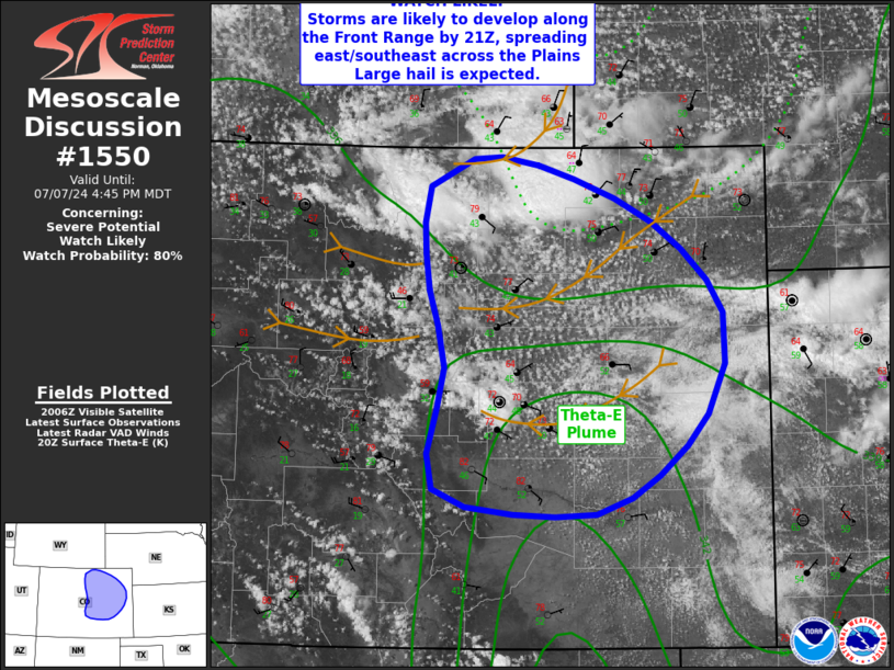
   Mesoscale Discussion 1550
   NWS Storm Prediction Center Norman OK
   0312 PM CDT Sun Jul 07 2024

   Areas affected...north-central into much of eastern Colorado

   Concerning...Severe potential...Watch likely

   Valid 072012Z - 072245Z

   Probability of Watch Issuance...80 percent

   SUMMARY...Storms are likely to increase along the Front Range this
   afternoon, with many producing hail and locally strong gusts as they
   continue into the Plains through evening.

   DISCUSSION...Visible imagery shows an expansive cumulus field over
   much of eastern Colorado where surface winds remain out of the east
   and northeast. Weak thunderstorms have developed into far
   north-central CO with increasing northern surface winds with high
   pressure to the north. Pressures continue to fall near the Colorado
   Springs area.

   While pockets of drier air do exist around the Denver area, in
   general, a moist air mass exists, especially over southeast CO with
   mid to upper 50s F dewpoints. Given cool midlevel temperatures,
   additional heating will result in sufficient instability to
   sustained scattered severe cells. Low-level/weak easterlies below
   increasing mid to high level winds will result in favorable shear
   profiles for large hail. By evening, storms are expected to
   consolidate into an MCS pushing into southeast CO, with damaging
   winds possible.

   ..Jewell/Guyer.. 07/07/2024

   ...Please see www.spc.noaa.gov for graphic product...

   ATTN...WFO...GLD...PUB...BOU...

   LAT...LON   40410325 39680252 38870267 38190345 38050424 38270551
               39230539 39850555 40400559 40680553 40900509 40860442
               40410325
|
|
Top/All Mesoscale Discussions/Forecast Products/Home
|
|


 @NWSSPC