|
| Mesoscale Discussion 1549 |
|
< Previous MD Next MD >
|
|
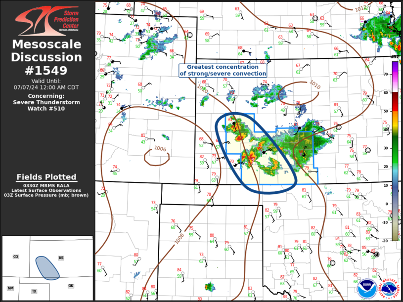
   Mesoscale Discussion 1549
   NWS Storm Prediction Center Norman OK
   1032 PM CDT Sat Jul 06 2024

   Areas affected...Southwest Kansas region

   Concerning...Severe Thunderstorm Watch 510...

   Valid 070332Z - 070500Z

   The severe weather threat for Severe Thunderstorm Watch 510
   continues.

   SUMMARY...Strong/severe convection will spread across southwest
   Kansas toward extreme northwest Oklahoma into the early-morning
   hours.

   DISCUSSION...A slow-moving cluster of severe thunderstorms has
   overspread the western half of ww510. This activity is propagating
   southeast into a strengthening LLJ that extends across the eastern
   TX Panhandle into southwest KS. Latest radar trends suggest
   new/robust updrafts are evolving over southwest KS, and satellite
   imagery suggests convection is now deepening over Wichita County,
   about 40 mi northwest of Garden City. Leading edge of the complex is
   not moving particularly fast as there is a propensity for new
   updrafts along the northwest flank, where low-level warm advection
   may be maximized. With time this evolving MCS should progress into
   northwest OK, and the primary risk remains damaging winds.

   ..Darrow.. 07/07/2024

   ...Please see www.spc.noaa.gov for graphic product...

   ATTN...WFO...OUN...DDC...GLD...AMA...

   LAT...LON   38600036 37079899 36900044 38400140 38600036
|
|
Top/All Mesoscale Discussions/Forecast Products/Home
|
|


 @NWSSPC