|
| Mesoscale Discussion 1547 |
|
< Previous MD Next MD >
|
|
Mesoscale Discussion 1547
NWS Storm Prediction Center Norman OK
0520 PM CDT Sat Jul 06 2024
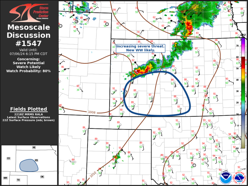
Areas affected...southwest Kansas
Concerning...Severe potential...Watch likely
Valid 062220Z - 062315Z
Probability of Watch Issuance...80 percent
SUMMARY...Severe thunderstorms will propagate south across western
Kansas this evening. New severe thunderstorm watch will likely be
issued soon.
DISCUSSION...An upward-evolving squall line has developed across
western KS just ahead of the primary synoptic front that is surging
south across the central high Plains. Northwesterly mid-level flow
will increase across western KS this evening and latest model
guidance favors a marked increase in the LLJ from the TX Panhandle
into southwest KS. This strongly supports a long-lived MCS that
should progress across southwest KS with an attendant risk for
wind/hail.
..Darrow/Hart.. 07/06/2024
...Please see www.spc.noaa.gov for graphic product...
ATTN...WFO...ICT...DDC...GLD...
LAT...LON 38320113 38699908 37219819 37170095 38320113
|
|
Top/All Mesoscale Discussions/Forecast Products/Home
|
|


 @NWSSPC