|
| Mesoscale Discussion 1303 |
|
< Previous MD Next MD >
|
|
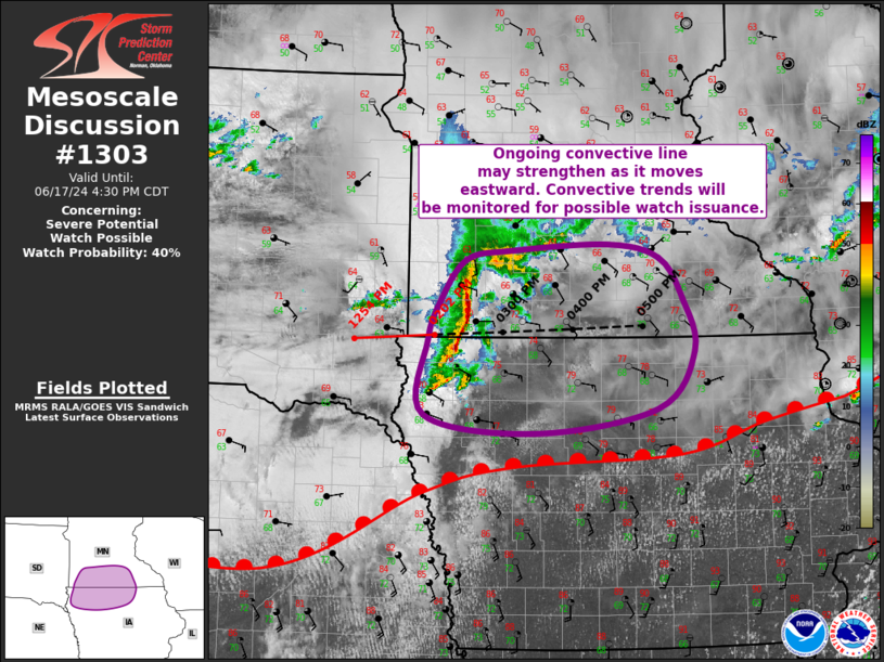
   Mesoscale Discussion 1303
   NWS Storm Prediction Center Norman OK
   0234 PM CDT Mon Jun 17 2024

   Areas affected...Northwest/North-Central
   IA...Southwest/South-Central MN

   Concerning...Severe potential...Watch possible

   Valid 171934Z - 172130Z

   Probability of Watch Issuance...40 percent

   SUMMARY...Ongoing convective line may strengthen as it moves
   eastward into more of south-central MN and north-central IA.
   Convective trends will be monitored closely to determine if a watch
   is needed.

   DISCUSSION...An elevated but organized convective line continues to
   progress eastward across southwest MN/northwest IA at around 35 to
   40 kt. The intensity of this line has been relatively steady over
   the past hour or so. New development has also been noted along the
   southern flank of this line. Recent surface analysis places a warm
   front from east-central NE northeastward across northern IA and into
   southwest MN, demarcated well by the 82 deg F isotherm. Northward
   progression of this warm front combined with the predominantly
   eastward motion of the convective line may result in the line
   trending towards becoming more surface based over the next hour or
   two. The airmass downstream continues to destabilize, with the
   general expectation that minimal convective inhibition will remain
   ahead of the line as it moves into south-central MN and
   north-central IA. This could result in intensification of the line,
   particularly if the line continues to build southward and increases
   the potential for interaction with the warm front.

   This scenario would likely merit watch issuance given the presence
   of strong buoyancy and vertical shear supportive of severe
   thunderstorms capable of all severe hazards. There is moderate
   forecast confidence in this scenario, but there is also some chance
   the line trends more northeastward into an airmass with less
   buoyancy and no interaction with the warm front. Severe
   thunderstorms would be unlikely in that scenario. Given the equal
   chances between either scenario, convective trends will be monitored
   closely and a watch may be needed if updrafts within the line begin
   to intensify.

   ..Mosier/Gleason.. 06/17/2024

   ...Please see www.spc.noaa.gov for graphic product...

   ATTN...WFO...ARX...MPX...DMX...FSD...

   LAT...LON   42779623 43469618 43819604 44219570 44309513 44379388
               44239321 43869291 43369276 42829323 42609480 42779623
|
|
Top/All Mesoscale Discussions/Forecast Products/Home
|
|


 @NWSSPC