|
| Mesoscale Discussion 1302 |
|
< Previous MD Next MD >
|
|
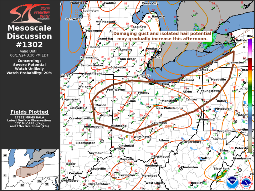
   Mesoscale Discussion 1302
   NWS Storm Prediction Center Norman OK
   1228 PM CDT Mon Jun 17 2024

   Areas affected...portions of eastern Indiana...northern and central
   Ohio...into far western New York/Pennsylvania

   Concerning...Severe potential...Watch unlikely

   Valid 171728Z - 171930Z

   Probability of Watch Issuance...20 percent

   SUMMARY...Storm coverage may gradually increase through the
   afternoon with one or more convective clusters possible. Storm
   organization should remain fairly limited, but damaging gusts and
   isolated hail will be possible with the stronger cores. A WW is not
   expected.

   DISCUSSION...As of 1720 UTC, regional radar and satellite data
   showed isolated thunderstorms had evolved out of a destabilizing air
   mass over parts of the mid and upper OH Valley. Located near the
   periphery of a large mid-level anticyclone and near a weak remnant
   MCV, forcing for ascent is rather nebulous and is likely primarily
   being driven by ongoing strong diurnal heating. As surface
   temperatures approach and breach convective temperatures, storm
   coverage should increase supported by 2000-3000 J/kg of MLCAPE from
   SPC mesoanalysis. Vertical shear is rather weak, generally less than
   20 kt, which should favor a multicellular storm mode. Some
   clustering of stronger cells is also expected given relatively high
   LCL heights (> 1500m) and steep low-level lapse rates supporting
   efficient downdrafts. This will likely favor damaging gusts with the
   stronger storms. Isolated hail may also be possible with the deeper
   and more persistent updrafts given the large magnitude of buoyancy.
   While a few stronger clusters of storms may evolve, the limited
   vertical shear and forcing for ascent suggest storm organization
   will be limited. Given the limited storm organization, a WW is not
   expected.

   ..Lyons/Halbert/Gleason.. 06/17/2024

   ...Please see www.spc.noaa.gov for graphic product...

   ATTN...WFO...BUF...CTP...PBZ...CLE...ILN...IWX...IND...

   LAT...LON   40788579 40898570 41098550 41398485 41558393 41518320
               41578177 42148021 42257985 42567897 42117900 41597923
               40967986 40438096 39658394 40008561 40788579
|
|
Top/All Mesoscale Discussions/Forecast Products/Home
|
|


 @NWSSPC