|
| Mesoscale Discussion 1300 |
|
< Previous MD Next MD >
|
|
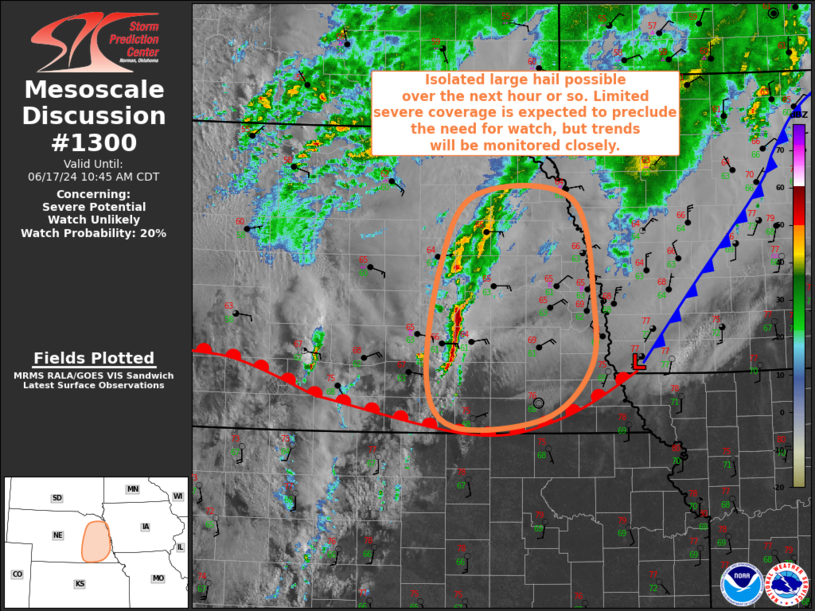
   Mesoscale Discussion 1300
   NWS Storm Prediction Center Norman OK
   0844 AM CDT Mon Jun 17 2024

   Areas affected...Eastern NE

   Concerning...Severe potential...Watch unlikely

   Valid 171344Z - 171545Z

   Probability of Watch Issuance...20 percent

   SUMMARY...Isolated large hail is possible across eastern Nebraska
   over the next hour or two. Limited severe coverage will likely
   preclude the need for a watch, but convective trends will be
   monitored closely.

   DISCUSSION...Regional radar imagery has shown an increase in
   thunderstorms along a north-south line from the OFK vicinity
   southward to around 20 miles southeast of HSI. Surface analysis
   reveals a warm front across southern NE, with this new development
   likely a result of warm-air advection across this frontal zone.
   Moderate elevated buoyancy is in place ahead of this line, with
   mesoanalysis estimation MUCAPE around 2000 J/kg. This elevated
   buoyancy will likely persist throughout the remainder of the
   morning, but the low-level jet is expected to gradually weaken. As a
   result, the general expectation is that this line will gradually
   diminish in intensity over the next few hours. Even so, sporadic
   intensification of the updrafts within this line is possible, with
   large hail as the primary severe risk. A strong gust or two is also
   possible given the modest low-level stability. Given the anticipated
   weakening of these storms, a watch is not currently expected, but
   convective trends will still be monitored closely.

   ..Mosier/Gleason.. 06/17/2024

   ...Please see www.spc.noaa.gov for graphic product...

   ATTN...WFO...FSD...OAX...GID...

   LAT...LON   40069782 40519818 41629802 42349757 42309629 41239602
               40609608 40149668 40069782
|
|
Top/All Mesoscale Discussions/Forecast Products/Home
|
|


 @NWSSPC