|
| Mesoscale Discussion 1299 |
|
< Previous MD Next MD >
|
|
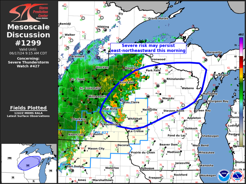
   Mesoscale Discussion 1299
   NWS Storm Prediction Center Norman OK
   0745 AM CDT Mon Jun 17 2024

   Areas affected...Western/northern Wisconsin to Upper Michigan

   Concerning...Severe Thunderstorm Watch 427...

   Valid 171245Z - 171415Z

   The severe weather threat for Severe Thunderstorm Watch 427
   continues.

   SUMMARY...At least isolated severe storms, capable of damaging winds
   and possibly some hail, will continue to focus across west-central
   Wisconsin through mid-morning, and may spread into additional parts
   of central/northern Wisconsin, where an additional Watch could be
   needed. Severe Thunderstorm Watch 427 continues until 15z.

   DISCUSSION...A relatively small-scale quasi-linear cluster remains
   strong/severe this morning as it approaches the I-94 corridor of
   west-central Wisconsin including the Eau Claire area. This cluster
   will likely continue northeastward, favoring the instability
   gradient that extends across southwest/west-central Wisconsin toward
   northeast Wisconsin and the eastern Upper Peninsula of Michigan.
   This cluster has a general history of severe-caliber wind gusts in
   the predawn hours, including a measured 53 kt gust at Rochester
   Minnesota. An additional Watch could be warranted for portions of
   central/northern Wisconsin pending short-term convective trends.

   ..Guyer.. 06/17/2024

   ...Please see www.spc.noaa.gov for graphic product...

   ATTN...WFO...MQT...GRB...DLH...ARX...MPX...

   LAT...LON   44519264 46009093 46248773 45648750 44898799 44408943
               43959104 44519264
|
|
Top/All Mesoscale Discussions/Forecast Products/Home
|
|


 @NWSSPC