|
| Mesoscale Discussion 1293 |
|
< Previous MD Next MD >
|
|
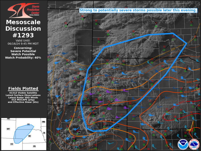
   Mesoscale Discussion 1293
   NWS Storm Prediction Center Norman OK
   0838 PM CDT Sun Jun 16 2024

   Areas affected...Northeast CO...southeast WY...NE Panhandle into
   northwest NE...southwest/south-central SD

   Concerning...Severe potential...Watch possible

   Valid 170138Z - 170345Z

   Probability of Watch Issuance...40 percent

   SUMMARY...Strong to potentially severe storms are possible later
   this evening, with large hail and localized severe gusts expected to
   be the primary threats.

   DISCUSSION...High-based convection is gradually strengthening east
   of Denver. The short-term evolution of this convection is uncertain,
   but it moves northeastward into an increasingly unstable environment
   across northeast CO, some further intensification is possible.
   Deep-layer shear is sufficient to support some storm organization,
   and some threat for hail and localized severe gusts could evolve if
   ongoing convection is able to mature.

   Later this evening, an increasing low-level jet (which is already
   noted on the KGLD VWP) will support the northward advance of
   stronger elevated buoyancy and the potential for elevated storm
   development across the NE Panhandle vicinity into
   southwest/south-central SD. Very steep midlevel lapse rates and
   sufficient deep-layer shear will support potential for organized
   convection, with a threat of large hail. The strongest storms within
   this regime could pose a conditional threat of very large hail,
   especially with any cells that are able to remain semi-discrete.
   Localized severe wind gusts will also be possible.

   Timing and the most favored corridor of the primary severe threat
   remain somewhat uncertain, but watch issuance will become
   increasingly probable across parts of the region by 9-10 PM MDT
   (10-11 PM CDT).

   ..Dean/Smith.. 06/17/2024

   ...Please see www.spc.noaa.gov for graphic product...

   ATTN...WFO...FSD...ABR...LBF...UNR...GLD...BOU...CYS...

   LAT...LON   40610208 39960318 39930391 40040425 40490448 41060463
               42500427 43180365 43430338 43960084 44009938 43569863
               42299986 40610208
|
|
Top/All Mesoscale Discussions/Forecast Products/Home
|
|


 @NWSSPC