|
| Mesoscale Discussion 1292 |
|
< Previous MD Next MD >
|
|
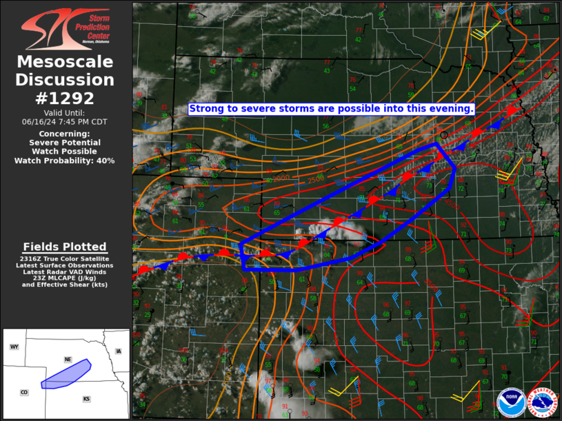
   Mesoscale Discussion 1292
   NWS Storm Prediction Center Norman OK
   0622 PM CDT Sun Jun 16 2024

   Areas affected...Southwest/central NE into northeast CO and
   northwest KS

   Concerning...Severe potential...Watch possible

   Valid 162322Z - 170045Z

   Probability of Watch Issuance...40 percent

   SUMMARY...Strong to severe thunderstorms are possible this evening.

   DISCUSSION...Convective initiation is underway just southwest of
   McCook, NE, in the vicinity of a nearly stationary front draped from
   northeast CO into south-central/northeast NE. Strong buoyancy is in
   place within the rather hot and well-mixed environment along/south
   of the front, along with sufficient effective shear (generally 30-35
   kt) for some storm organization. Storm coverage may remain rather
   isolated in the short term in the absence of stronger large-scale
   ascent, but an isolated supercell or two could form near the front
   into the early evening, with a threat of large hail and localized
   severe gusts.

   Watch issuance in the short term is uncertain, but remains possible
   if the threat for multiple severe storms appears imminent. Later
   this evening, a general increase in elevated storm coverage
   (including the potential for hail) is expected north of the front as
   a low-level jet intensifies, with watch issuance becoming possible
   across a larger portion of the region.

   ..Dean/Smith.. 06/16/2024

   ...Please see www.spc.noaa.gov for graphic product...

   ATTN...WFO...OAX...GID...LBF...GLD...

   LAT...LON   39710011 39490128 39490239 39920248 40400135 40820036
               41489862 41599824 41189783 40859796 40369875 39979944
               39710011
|
|
Top/All Mesoscale Discussions/Forecast Products/Home
|
|


 @NWSSPC