|
| Mesoscale Discussion 1284 |
|
< Previous MD Next MD >
|
|
Mesoscale Discussion 1284
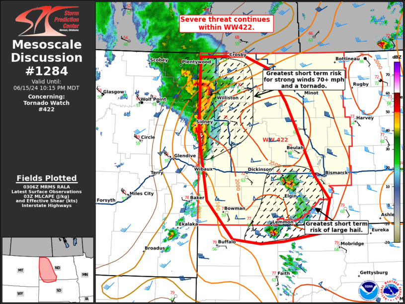
NWS Storm Prediction Center Norman OK
1008 PM CDT Sat Jun 15 2024
Areas affected...western North Dakota into far northwestern South
Dakota
Concerning...Tornado Watch 422...
Valid 160308Z - 160415Z
The severe weather threat for Tornado Watch 422 continues.
SUMMARY...Severe risk continues within WW422, with potential for
large hail, damaging winds, and a tornado or two.
DISCUSSION...A line of severe thunderstorms continues to move
eastward into western North Dakota, with potential for damaging
winds 60-75 mph (some instances 75+ mph). This line of storms
continues to move into a favorably unstable environment with strong
deep layer shear and steep lapse rates. More favorable low-level
wind profiles are observed across northwestern North Dakota, where
0-3 km shear values are around 40-45 kts with 0-1 km shear around 20
kts. This may lead to some increase of risk for embedded
mesovortices and a tornado or two within the line.
Further south across southwestern North Dakota near the South Dakota
border, more discrete convection is ongoing with history of
producing hail up to baseball size. Given the weaker low-level shear
profiles in this region, the main threats are likely to continue to
be large hail and damaging wind, though a tornado cannot be ruled
out with more mature supercell modes.
..Thornton.. 06/16/2024
...Please see www.spc.noaa.gov for graphic product...
ATTN...WFO...ABR...BIS...UNR...GGW...
LAT...LON 47560404 48930402 48950286 48740224 48120175 46840104
46380064 45790082 45640183 45610242 45680314 46380381
47560404
|
|
Top/All Mesoscale Discussions/Forecast Products/Home
|
|


 @NWSSPC