|
| Mesoscale Discussion 1276 |
|
< Previous MD Next MD >
|
|
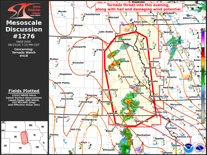
   Mesoscale Discussion 1276
   NWS Storm Prediction Center Norman OK
   0544 PM CDT Sat Jun 15 2024

   Areas affected...Eastern NE...northeast KS...southeast SD...western
   IA

   Concerning...Tornado Watch 418...

   Valid 152244Z - 160015Z

   The severe weather threat for Tornado Watch 418 continues.

   SUMMARY...The tornado threat may increase into this evening, along
   with continued hail and damaging-wind potential.

   DISCUSSION...Supercells have recently developed across northeast NE,
   with another somewhat less organized cluster moving northeastward
   out of southeast NE. Gradual heating and moistening through the day
   has resulted in moderate to strong destabilization, with MLCAPE of
   2000-3000 J/kg across the region per recent objective mesoanalyses.
   The low-level wind profile depicted by KOAX and KFSD VWPs is
   favorable for potentially tornadic supercells, with favorable
   hodograph curvature (0-1 km SRH of greater than 150 m2/s2) and 30-40
   kt of flow at 1-3 km above the surface. Rather modest midlevel flow
   is less favorable, though, which could result in a tendency toward
   storm clustering with time.

   The greatest short-term tornado threat appears to reside across
   northeast NE, given the presence of ongoing semi-discrete
   supercells. However, the environment downstream of the southeast NE
   storm cluster also remains favorable for a tornado or two as
   convection approaches the MO River Valley early this evening, along
   with some threat for isolated hail and damaging wind.

   ..Dean.. 06/15/2024

   ...Please see www.spc.noaa.gov for graphic product...

   ATTN...WFO...EAX...FSD...OAX...TOP...GID...

   LAT...LON   39709759 41829816 42469820 43059759 43229655 43019599
               40839568 40039556 39599660 39599707 39709759
|
|
Top/All Mesoscale Discussions/Forecast Products/Home
|
|


 @NWSSPC