|
| Mesoscale Discussion 1275 |
|
< Previous MD Next MD >
|
|
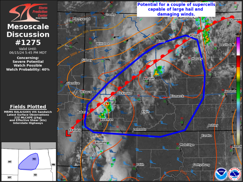
   Mesoscale Discussion 1275
   NWS Storm Prediction Center Norman OK
   0511 PM CDT Sat Jun 15 2024

   Areas affected...parts of western and central North Dakota

   Concerning...Severe potential...Watch possible

   Valid 152211Z - 152345Z

   Probability of Watch Issuance...40 percent

   SUMMARY...A couple supercells capable of damaging winds and large
   hail possible in the near term.

   DISCUSSION...Thunderstorms have developed near the surface low
   across the MT/ND/SD border and along a warm front extending across
   central North Dakota in the last hour. Daytime heating and
   increasing low-level moisture has led to dew points in the mid to
   upper 60s with MLCAPE around 1000-2500 J/kg across southern/central
   North Dakota. Deep-layer shear around 40-45 kts is in place across
   western North Dakota, weakening with eastward extent. The 20z
   sounding from BIS shows rather marginal deep-layer shear for
   organized storms (around 20 kts). The profile also shows ample
   instability with 1900 J/kg of MLCAPE and steep lapse rates around 7
   C/km throughout the profile. Cells that form along and near the warm
   front and in western ND where stronger deep-layer shear resides, may
   take on supercellular modes capable of large hail and damaging winds
   in the short term. There is considerable uncertainty in the
   near-term coverage of the severe threat, given the poor handling of
   this scenario in CAMs. Given uncertainty in coverage, a watch is not
   likely at this time but this area will be monitored for trends.

   ..Thornton/Smith.. 06/15/2024

   ...Please see www.spc.noaa.gov for graphic product...

   ATTN...WFO...FGF...ABR...BIS...UNR...

   LAT...LON   45790112 45900361 46030391 46160396 46610386 47190311
               47940178 48190120 48300072 48420012 48309968 47849952
               47449942 46809949 45960021 45790112
|
|
Top/All Mesoscale Discussions/Forecast Products/Home
|
|


 @NWSSPC