|
| Mesoscale Discussion 1274 |
|
< Previous MD Next MD >
|
|
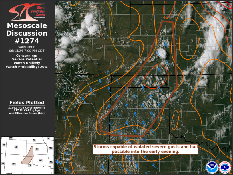
   Mesoscale Discussion 1274
   NWS Storm Prediction Center Norman OK
   0501 PM CDT Sat Jun 15 2024

   Areas affected...Parts of the central/southern High Plains

   Concerning...Severe potential...Watch unlikely

   Valid 152201Z - 160000Z

   Probability of Watch Issuance...20 percent

   SUMMARY...Storms capable of isolated severe gusts and hail will be
   possible into the early evening.

   DISCUSSION...High-based thunderstorms have recently developed across
   southwest KS, with increasing cumulus noted farther south into the
   TX/OK Panhandles and TX South Plains vicinity. With a
   mid/upper-level shortwave trough currently over central KS moving
   away from the region with time, storm coverage may remain somewhat
   isolated into the early evening. However, MLCAPE of greater than
   1500 J/kg and modestly favorable deep-layer shear will support a few
   marginally organized storms. Isolated severe gusts will be possible
   within the relatively warm and well-mixed environment across the
   region, with the strongest storms also potentially capable of
   producing some hail.

   ..Dean/Smith.. 06/15/2024

   ...Please see www.spc.noaa.gov for graphic product...

   ATTN...WFO...OUN...DDC...GLD...LUB...AMA...ABQ...

   LAT...LON   35060077 34440135 34480295 34650345 35110352 35400310
               37680113 39290028 39239974 36539956 35060077
|
|
Top/All Mesoscale Discussions/Forecast Products/Home
|
|


 @NWSSPC