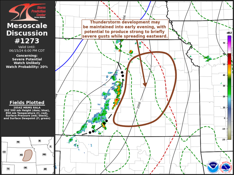
   Mesoscale Discussion 1273
   NWS Storm Prediction Center Norman OK
   0357 PM CDT Sat Jun 15 2024

   Areas affected...parts of central into eastern Kansas

   Concerning...Severe potential...Watch unlikely

   Valid 152057Z - 152300Z

   Probability of Watch Issuance...20 percent

   SUMMARY...Increasing thunderstorm development possible through 5-7
   PM CDT, with strong gusts approaching or perhaps briefly exceeding
   severe limits the primary potential hazard.

   DISCUSSION...Thunderstorm development has recently increased and
   intensified along the leading edge of outflow associated with
   weakening initial convective development approaching the I-135/35
   corridor of central Kansas.  The boundary layer immediately ahead of
   this activity has become strongly heated and deeply mixed (with
   surface dew points falling into the lower 60s F as temperatures rose
   into the mid 90s F), but may still be characterized by weak to
   modest CAPE.  Aided by forcing for ascent associated with weak
   mid-level troughing overspreading the central Great Plains, this may
   be sufficient to maintain convection along deepening/strengthening
   convective outflow  spreading northeastward and eastward through
   early evening.

   Although deep-layer shear is weak, the low-level thermodynamic
   profiles, coupled with 20-30 kt south to southwesterly mean flow in
   the lower/mid-troposphere, probably will be conducive to a few
   localized strong to severe downbursts, initially.  Gradually,
   though, gusty winds along consolidating outflows are expected to
   become the most prominent potential hazard, perhaps approaching or
   briefly exceeding severe limits.

   ..Kerr/Gleason.. 06/15/2024

   ...Please see www.spc.noaa.gov for graphic product...

   ATTN...WFO...TOP...ICT...

   LAT...LON   38379755 39409727 39569589 38709555 37519632 37409791
               38379755
|


 @NWSSPC