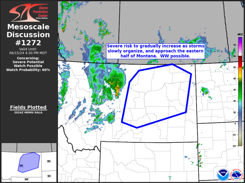
   Mesoscale Discussion 1272
   NWS Storm Prediction Center Norman OK
   0327 PM CDT Sat Jun 15 2024

   Areas affected...central and eastern Montana

   Concerning...Severe potential...Watch possible

   Valid 152027Z - 152230Z

   Probability of Watch Issuance...60 percent

   SUMMARY...Storms have begun to show signs of upscale growth across
   parts of central Montana.  Risk for damaging wind gusts should
   gradually increase, possibly requiring eventual WW issuance.

   DISCUSSION...Latest radar imagery shows that storms just east of
   Great Falls have exhibited some upscale growth in the past hour, as
   continued heating/weak destabilization combined with low-level
   southeasterly flow impinges on eastward-moving outflow.  The latest
   Great Falls (KFTX) WSR-88D even suggests some evidence of a weak
   mesolow crossing northern Chouteau County.

   While storms are occurring with the axis of relatively greater
   instability at this time, with slightly less unstable, more capped
   environment still evident in central Montana, short-term prospects
   for convective intensity remain somewhat uncertain.  Still, with
   instability increasing farther east, over eastern Montana, it would
   seem that coverage/intensity of convection will likely become such
   that WW issuance will need to be considered.  Though timing of this
   potential need for a watch remains uncertain, we will continue to
   closely monitor the evolving situation across central Montana.

   ..Goss/Gleason.. 06/15/2024

   ...Please see www.spc.noaa.gov for graphic product...

   ATTN...WFO...BYZ...GGW...TFX...

   LAT...LON   48090907 48670836 49000579 48480437 46530485 45740845
               46030958 48090907
|


 @NWSSPC