|
| Mesoscale Discussion 1265 |
|
< Previous MD Next MD >
|
|
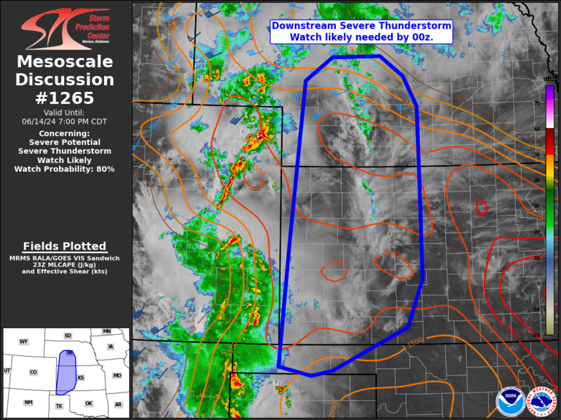
   Mesoscale Discussion 1265
   NWS Storm Prediction Center Norman OK
   0604 PM CDT Fri Jun 14 2024

   Areas affected...Southwestern Nebraska...western Kansas...portions
   of the Oklahoma Panhandle

   Concerning...Severe potential...Severe Thunderstorm Watch likely

   Valid 142304Z - 150000Z

   Probability of Watch Issuance...80 percent

   SUMMARY...A Severe Thunderstorm Watch will be needed downstream of
   WW414 by 00z.

   DISCUSSION...Broken linear structures and clusters of thunderstorm
   activity have been ongoing across portions of western Colorado and
   New Mexico, with a few instances of severe winds reported in
   southern Colorado. CAM guidance suggests thunderstorm activity will
   continue to increase in coverage and merge with deepening cold pools
   as activity shifts eastward into the central Great Plains this
   evening.

   The air mass downstream of WW414 is characterized by MLCAPE around
   1000-1400 J/kg and steep low to mid-level lapse rates. An increase
   in southerly low-level jet is expected along the
   Colorado/Kansas/Nebraska border through the evening. This will
   support a continued risk of damaging wind, with gusts 60-75 mph
   (isolated 75+ mph). Given modest shear profiles, some instances of
   severe hail will be possible but the main threat will likely
   continue to be damaging wind. A new Severe Thunderstorm Watch will
   likely be needed downstream of WW414 soon.

   ..Thornton/Smith.. 06/14/2024

   ...Please see www.spc.noaa.gov for graphic product...

   ATTN...WFO...ICT...OUN...GID...LBF...DDC...GLD...AMA...

   LAT...LON   41440153 41840094 41869987 41539937 41029907 39619903
               38099899 37289931 36550091 36460134 36610203 38780184
               41440153
|
|
Top/All Mesoscale Discussions/Forecast Products/Home
|
|


 @NWSSPC