|
| Mesoscale Discussion 947 |
|
< Previous MD Next MD >
|
|
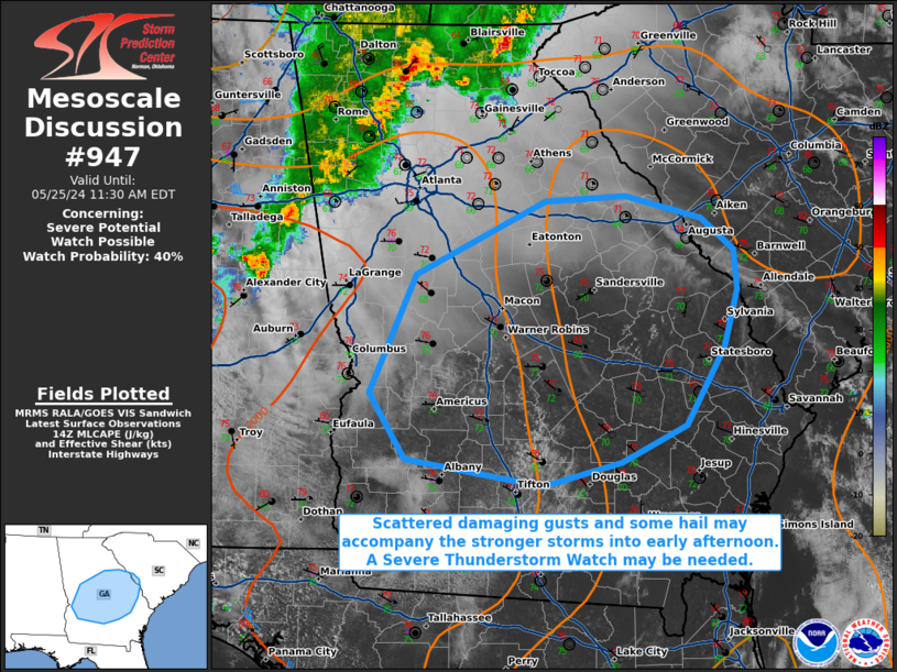
   Mesoscale Discussion 0947
   NWS Storm Prediction Center Norman OK
   0903 AM CDT Sat May 25 2024

   Areas affected...portions of central and southern Georgia into far
   western South Carolina

   Concerning...Severe potential...Watch possible

   Valid 251403Z - 251530Z

   Probability of Watch Issuance...40 percent

   SUMMARY...Storms may strengthen from sometime late this morning into
   early afternoon. Damaging gusts and hail will be the primary
   threats. Convective trends are being monitored for the need of a
   Severe Thunderstorm Watch.

   DISCUSSION...A loosely organized cluster of thunderstorms continues
   to propagate southeast toward an airmass that continues to
   destabilize with continued strong diurnal heating. Surface
   temperatures are already warming into the 80s F amid low 70s F
   dewpoints, where over 1000 J/kg MLCAPE is already in place. Some
   MLCINH remains in place, but continued heating should erode
   remaining inhibition and steepen low-level lapse rates, both
   boosting instability and mixing the boundary layer in the process.
   Should the ongoing convective cluster persist, opportunity exists
   for stronger wet downbursts to ensue, with damaging gusts becoming a
   concern. A 40 kt 500 mb speed max will also graze by the region to
   the southwest, contributing to some hodograph elongation, fostering
   some hail potential (perhaps to severe limits).

   Given overall severe potential, convective trends will continue to
   be monitored for the need of a WW issuance.

   ..Squitieri/Bunting.. 05/25/2024

   ...Please see www.spc.noaa.gov for graphic product...

   ATTN...WFO...CHS...CAE...JAX...FFC...TAE...

   LAT...LON   32198481 33098439 33648323 33698252 33518184 33288155
               32988152 32538164 31948197 31678255 31488326 31698448
               32198481
|
|
Top/All Mesoscale Discussions/Forecast Products/Home
|
|


 @NWSSPC