|
| Mesoscale Discussion 2041 |
|
< Previous MD Next MD >
|

|
   Mesoscale Discussion 2041
   NWS Storm Prediction Center Norman OK
   1111 PM CST Wed Dec 14 2022

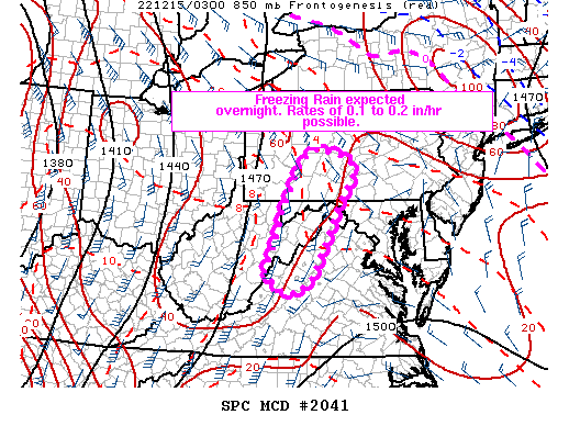
   Areas affected...Portions of northwestern Virginia and Maryland into
   eastern West Virginia and southern Pennsylvania

   Concerning...Freezing rain

   Valid 150511Z - 151115Z

   SUMMARY...Freezing rain will increase in intensity overnight across
   portions of the Blue Ridge Mountains. Rates of 0.1 to 0.2 inches per
   hour.

   DISCUSSION...As of 0500 UTC, surface observations within the Blue
   Ridge mountains of WV and VA were showing surface temperatures
   decreasing to near or below freezing. Likely in response to dynamic
   cooling from moderate to heavy stratiform precipitation moving
   overhead, temperatures should continue to fall below freezing within
   higher valleys overnight. Driven primarily by mid-level warm
   advection ahead of an advancing shortwave trough over the Midwest,
   precipitation should also continue to intensify above the cooling
   surface temperatures. Area RAP soundings show a prominent elevated
   1-3 C warm nose extending northward into western MD and southern PA
   with the warm advection band. Periods of moderate freezing rain
   appear likely with rates of 0.1 to 0.2 in/hr possible. The highest
   confidence in freezing rain will be confined to the higher valleys
   of northwestern MD/VA, eastern WV and southern PA through early this
   morning. Some sleet and snow may also mix in later this morning
   before temperatures begin to warm.

   ..Lyons.. 12/15/2022

   ...Please see www.spc.noaa.gov for graphic product...

   ATTN...WFO...CTP...LWX...RNK...PBZ...RLX...

   LAT...LON   38287988 38897960 39587938 40577893 40787851 40677792
               40507762 40237757 39597798 38957827 38107872 37847907
               37927954 38287988
|
|
Top/All Mesoscale Discussions/Forecast Products/Home
|
|


