|
| Mesoscale Discussion 1598 |
|
< Previous MD Next MD >
|
|
Mesoscale Discussion 1598
NWS Storm Prediction Center Norman OK
0241 PM CDT Thu Aug 27 2020
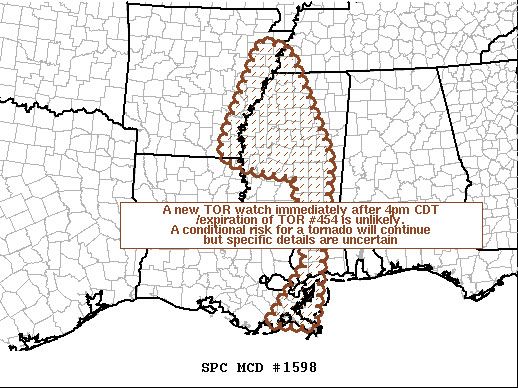
Areas affected...southeast LA...southern into northern MS...eastern
AR...southwestern TN
Concerning...Tornado Watch 454...
Valid 271941Z - 272115Z
The severe weather threat for Tornado Watch 454 continues.
SUMMARY...Tornado watch #454 will expire at 4pm CDT. A new tornado
watch will likely not be issued immediately following the end of
tornado watch #454. A highly conditional risk for a tornado will
continue but specific details are uncertain.
DISCUSSION...Radar mosaic shows a rain shield across AR in
association with Laura as it moves north-northeast. Farther
southeast, a decayed band of convection extends from northern MS
into east-central MS. Farther south, linearly oriented convection
with outflow-dominate tendencies extends from far southeast LA to
the MS coast. The airmass from the LA/MS coast northward to the
greater Memphis area is warm/moist with lower 80s temperatures and
mid-upper 70s F dewpoints. However, the lack of sustained
convective development within the eastern half of Tropical Storm
Laura's remnants, are suggestive of implied large-scale descent.
This appears to be supported by water-vapor imagery/objective
analysis fields showing the upper PV anomaly moving northeastward
into northwest MS and eastern AR away from the Gulf Coast.
Farther north in eastern AR/western TN, the widespread rain shield
has limited the ability for destabilization despite very moist
profile. The hodographs across this region (KNQA) remain very
strongly sheared but the lack of robust updraft development has
nullified the risk for a tornado through the mid afternoon.
Although highly conditional, if cellular updrafts can emerge on the
south flank of the rain shield, a localized mini supercell tornado
risk may evolve for a few hours.
..Smith.. 08/27/2020
...Please see www.spc.noaa.gov for graphic product...
ATTN...WFO...MOB...MEG...JAN...LIX...LZK...
LAT...LON 29289037 30628939 32578966 32829123 33159176 35739064
35578984 32998870 29228917 29289037
|
|
Top/All Mesoscale Discussions/Forecast Products/Home
|
|


 @NWSSPC