|
| Mesoscale Discussion 1398 |
|
< Previous MD Next MD >
|
|
Mesoscale Discussion 1398
NWS Storm Prediction Center Norman OK
0205 PM CDT Tue Aug 04 2020
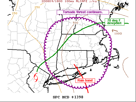
Areas affected...Southeast NY...Eastern Long Island...Southern
VT...Southern NH...MA...CT...RI
Concerning...Tornado Watch 416...417...
Valid 041905Z - 042030Z
The severe weather threat for Tornado Watch 416, 417 continues.
SUMMARY...Threat for tornadoes will continue across southern New
England for the next several hours.
DISCUSSION...Latest surface observations and satellite/radar imagery
places the center of Tropical Storm Isaias over northern NJ (about
20-30 miles west-northwest of EWR). Several storms within a rain
band arcing from about 110 miles northeast of the center to 150 east
of the center have shown persistently deep updrafts and rotation
while approaching central/eastern Long Island. However, interaction
with land has caused these low-topped cells to lose much of their
low-level rotation once onshore.
Large, looping low-level hodographs will remain in place over
southern New England as the strong low to mid-level winds associated
with Isaias persist across the region. Warm temperatures aloft will
temper instability area wide, with the highest SBCAPE and MLCAPE
values remaining over areas where the dewpoints are at or above 70
deg F. Given the more favorable low-level thermodynamics, areas
across RI, eastern CT, and eastern MA appear to have the greatest
tornado threat. The more hostile/stable environment across eastern
NY, southern VT, and southern NH suggests a somewhat lower tornado
threat across these areas for the next few hours.
Tornado Watch 416 will be allowed to expire at 20Z.
..Mosier.. 08/04/2020
...Please see www.spc.noaa.gov for graphic product...
ATTN...WFO...GYX...BOX...BTV...OKX...ALY...
LAT...LON 41157387 42277418 43197359 43367188 42527045 40877100
40487243 41157387
|
|
Top/All Mesoscale Discussions/Forecast Products/Home
|
|


 @NWSSPC