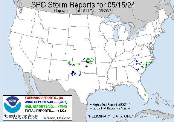
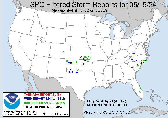
| Tornado Reports (CSV) (Raw Tornado CSV)(?) |
|---|
| No reports received |
| Hail Reports (CSV) (Raw Hail CSV)(?) |
|---|
Time | Size | Location | County | State | Lat | Lon | Comments |
| 1630 | 150 | Roseland | Indian River | FL | 2784 | 8049 | Picture of hail around ping pong ball size in Roseland received via social media. (MLB) |
| 1631 | 150 | Micco | Brevard | FL | 2787 | 8052 | Picture of hail around ping pong ball size in Micco received via social media. (MLB) |
| 1730 | 100 | 6 NW Briarcliffe Acres | Horry | SC | 3386 | 7881 | Quarter size hail reported via social media just off Hwy 22 and Hwy 90 near Wendys restaurant and Speedway gas station. (ILM) |
| 1825 | 100 | 2 NNE Cajah's Mountain | Caldwell | NC | 3587 | 8152 | Hail from pea sized up to quarter sized. (GSP) |
| 1931 | 100 | 3 SE Hickory | Catawba | NC | 3570 | 8131 | Report from mPING: Quarter (1.00 in.). (GSP) |
| 2021 | 100 | Indian Trail | Union | NC | 3507 | 8068 | Mostly dime sized but some quarter sized. (GSP) |
| 2029 | 100 | Clayton | Union | NM | 3653 | 10318 | (ABQ) |
| 2030 | 150 | 1 S Clayton | Union | NM | 3643 | 10317 | (ABQ) |
| 2035 | 100 | 1 W Clayton | Union | NM | 3645 | 10319 | Corrects previous hail report from 1 W Clayton. (ABQ) |
| 2038 | 100 | 1 W Clayton | Union | NM | 3645 | 10319 | (ABQ) |
| 2054 | 100 | Texline | Dallam | TX | 3638 | 10302 | Public report ... time estimated on radar. (AMA) |
| 2100 | 100 | 6 WNW Ellicott | El Paso | CO | 3889 | 10448 | Picture of 1 inch diameter hail from social media. (PUB) |
| 2105 | 175 | 7 S Turbeville | Clarendon | SC | 3380 | 7999 | Public sent in pictures of hail and wind damage to their property. The pictures shows golf ball size hail along with wind damage to their property. There were several l (CAE) |
| 2110 | 100 | 5 ENE Waxhaw | Union | NC | 3496 | 8066 | Mineral Springs. (GSP) |
| 2115 | 175 | 2 NNW Hebron | Williamsburg | SC | 3385 | 7989 | Media relayed report via social media of golf ball size hail in the Barrineau community around 515 pm. (ILM) |
| 2115 | 100 | 7 E Texline | Dallam | TX | 3640 | 10289 | (AMA) |
| 2122 | 150 | Lake City | Florence | SC | 3387 | 7975 | Quarter to ping pong size hail in Lake City and Barrineau relayed by media. Time estimated by radar. (ILM) |
| 2125 | 100 | Scranton | Florence | SC | 3392 | 7974 | Nickel to quarter size hail relayed by media. (ILM) |
| 2125 | 100 | 6 N Garland | Sampson | NC | 3487 | 7841 | Corrects previous hail report from 6 N Garland. Hail lasted 5 minutes. (RAH) |
| 2127 | 100 | 4 WSW Clinton | Sampson | NC | 3499 | 7839 | Reported near Bonnetsville ... just west of Clinton. (RAH) |
| 2130 | 175 | 3 SW Plainview | Hale | TX | 3416 | 10176 | Quarter to golf ball size. Time estimated. (LUB) |
| 2135 | 100 | 6 S Clinton | Sampson | NC | 3492 | 7833 | Report from mPING: Quarter (1.00 in.). (RAH) |
| 2149 | 175 | Cypress Creek | Duplin | NC | 3475 | 7771 | Delayed report. 911 center said a deputy called in to report large hail hitting his vehicle. He estimated the hail was up to golf ball size. Time estimated based on rad (MHX) |
| 2157 | 100 | 3 WSW Swansboro | Onslow | NC | 3468 | 7718 | (MHX) |
| 2200 | 100 | Hubert | Onslow | NC | 3473 | 7724 | Delayed report. 911 call operator had hail hitting her car on the way into work. She estimated that it was around quarter size. Time estimated based on radar. (MHX) |
| 2211 | 100 | Swansboro | Onslow | NC | 3469 | 7713 | Picture relayed via Facebook. (MHX) |
| 2211 | 125 | 5 N Dalhart | Dallam | TX | 3614 | 10251 | (AMA) |
| 2217 | 100 | 1 SE Peletier | Carteret | NC | 3472 | 7707 | (MHX) |
| 2217 | 200 | Peletier | Carteret | NC | 3473 | 7708 | Corrects previous hail report from Peletier. Delayed report. Picture of hail of at least 2 inches in diameter submitted via Facebook. Time estimated based on radar. Cor (MHX) |
| 2219 | 100 | 2 ESE Stella | Carteret | NC | 3476 | 7711 | (MHX) |
| 2235 | 100 | 1 ESE Half Moon | Onslow | NC | 3482 | 7745 | Picture relayed via Facebook. Hailstone was next to a dime ... and was larger. (MHX) |
| 2303 | 100 | 4 NE Forestbrook | Horry | SC | 3376 | 7892 | Quarter sized hail on Dandelion Lane (ILM) |
| 2313 | 175 | 4 N Clarkton | Bladen | NC | 3455 | 7864 | (ILM) |
| 2315 | 200 | 4 NE Caldwell | Sumner | KS | 3707 | 9756 | Delayed report. (ICT) |
| 2323 | 275 | 6 ENE Clarkton | Bladen | NC | 3452 | 7856 | Baseball sized hail near the intersection of Lisbon Rd and Rosindale Rd. Hail damaged windshields on cars. (ILM) |
| 2327 | 100 | Sunray | Moore | TX | 3602 | 10182 | (AMA) |
| 2332 | 125 | Sunray | Moore | TX | 3602 | 10182 | time estimated on radar. (AMA) |
| 2334 | 100 | Caldwell | Sumner | KS | 3704 | 9761 | Report from mPING: Quarter (1.00 in.). (ICT) |
| 2335 | 100 | Sunray | Moore | TX | 3602 | 10183 | (AMA) |
| 2338 | 175 | 3 N Caldwell | Sumner | KS | 3708 | 9760 | Report from mPING: Golf Ball (1.75 in.). (ICT) |
| 2340 | 175 | 6 ENE Clarkton | Bladen | NC | 3452 | 7856 | Golfball sized hail at the intersection of Lisbon Rd and Rosindale Rd. (ILM) |
| 2342 | 150 | 1 S Georgetown | Georgetown | SC | 3334 | 7929 | Quarter to ping pong size hail in Maryville relayed by media via social media. (ILM) |
| 2351 | 100 | 3 N Stinnett | Hutchinson | TX | 3587 | 10144 | (AMA) |
| 2351 | 175 | 3 NW Braman | Kay | OK | 3695 | 9738 | (OUN) |
| 2353 | 100 | 4 NW Belle Plaine | Sumner | KS | 3743 | 9733 | (ICT) |
| 0000 | 150 | 5 N Braman | Kay | OK | 3699 | 9735 | ODOT camera on I-35. (OUN) |
| 0001 | 100 | Mulvane | Sedgwick | KS | 3748 | 9724 | (ICT) |
| 0003 | 100 | 9 E Morse | Hutchinson | TX | 3602 | 10133 | Report from mPING: Quarter (1.00 in.). (AMA) |
| 0005 | 250 | Braman | Kay | OK | 3693 | 9733 | (OUN) |
| 0015 | 175 | 2 W Rose Hill | Sedgwick | KS | 3756 | 9717 | (ICT) |
| 0016 | 150 | Rose Hill | Butler | KS | 3757 | 9713 | (ICT) |
| 0027 | 100 | 3 NNW Shattuck | Ellis | OK | 3632 | 9989 | (OUN) |
| 0032 | 125 | Newkirk | Kay | OK | 3688 | 9706 | (OUN) |
| 0035 | 400 | Newkirk | Kay | OK | 3688 | 9706 | (OUN) |
| 0039 | 150 | 3 W Kildare | Kay | OK | 3680 | 9710 | Report from mPING: Ping Pong Ball (1.50 in.). (OUN) |
| 0040 | 100 | Arnett | Ellis | OK | 3613 | 9977 | (OUN) |
| 0040 | 175 | 3 W Kildare | Kay | OK | 3680 | 9710 | Report from mPING: Golf Ball (1.75 in.). (OUN) |
| 0040 | 100 | 1 N Latham | Butler | KS | 3755 | 9664 | (ICT) |
| 0050 | 100 | Leon | Butler | KS | 3768 | 9678 | (ICT) |
| 0054 | 275 | 5 ESE Kildare | Kay | OK | 3677 | 9696 | (OUN) |
| 0111 | 175 | 5 S Kaw City | Osage | OK | 3669 | 9687 | Report from mPING: Golf Ball (1.75 in.). (TSA) |
| 0118 | 100 | Burbank | Osage | OK | 3670 | 9673 | (TSA) |
| 0127 | 300 | Burbank | Osage | OK | 3669 | 9673 | (TSA) |
| 0127 | 350 | Burbank | Osage | OK | 3670 | 9673 | 3.5 inch hail covered the ground. (TSA) |
| 0208 | 100 | 1 W Buffalo | Wilson | KS | 3771 | 9571 | (ICT) |
| 0216 | 150 | Wynona | Osage | OK | 3655 | 9633 | (TSA) |
| 0230 | 100 | 1 ESE Avant | Osage | OK | 3648 | 9604 | On Highway 11 approximately 9 miles north of Skiatook. Relayed via Twitter. (TSA) |
| 0240 | 100 | 3 SE Douglass | Butler | KS | 3749 | 9697 | (ICT) |
| 0300 | 175 | 2 W Vera | Washington | OK | 3645 | 9592 | Golf ball size hail. (TSA) |
| 0303 | 100 | Vera | Washington | OK | 3645 | 9588 | Quarter size hail. (TSA) |
| 0425 | 150 | Sedan | Chautauqua | KS | 3713 | 9618 | quarter to golf ball sized. (ICT) |
| 0625 | 175 | 9 SE Floydada | Floyd | TX | 3388 | 10125 | Time estimated from radar. (LUB) |
| 0636 | 175 | 1 NNE Parsons | Labette | KS | 3735 | 9526 | (ICT) |
| 0838 | 150 | 1 SW Lockett | Wilbarger | TX | 3408 | 9938 | Report from mPING: Ping Pong Ball (1.50 in.). (OUN) |
| 0841 | 175 | 9 S Lockett | Wilbarger | TX | 3396 | 9936 | Report from mPING: Golf Ball (1.75 in.). (OUN) |
| Wind Reports (CSV) (Raw Wind CSV)(?) |
|---|
Time | Speed | Location | County | State | Lat | Lon | Comments |
| 1835 | UNK | Cajah's Mountain | Caldwell | NC | 3585 | 8154 | Utility equipment damaged resulting in power outages. (GSP) |
| 1840 | UNK | 2 SSE Cajah's Mountain | Caldwell | NC | 3583 | 8152 | Trees and lines down along Horseshoe Bend Rd and Hickory Nut Ridge Road. (GSP) |
| 1845 | UNK | Gaffney | Cherokee | SC | 3508 | 8166 | One tree reported down in the city by the storm. (GSP) |
| 1845 | UNK | 1 S Sawmills | Caldwell | NC | 3580 | 8148 | Trees and utility lines downed along Dry Ponds Rd. (GSP) |
| 1920 | UNK | 1 W Longview | Burke | NC | 3573 | 8140 | Trees downed along 39th St NW. (GSP) |
| 1925 | UNK | 1 SSW Hildebran | Burke | NC | 3570 | 8143 | Trees downed along Henry River Rd. (GSP) |
| 1930 | UNK | 3 SE Norwood | Stanly | NC | 3520 | 8009 | Tree down on power lines along 4700 block of Fork Rd. (RAH) |
| 2009 | UNK | 2 NNE Blacksburg | Montgomery | VA | 3727 | 8040 | tree down. Time estimated from radar. (RNK) |
| 2020 | UNK | 4 SSW Edgefield | Edgefield | SC | 3374 | 8197 | SC Dept of Public Safety reports trees down across the road on Sweetwater Rd near the intersection of Horn Creek W. Time estimated from radar. (CAE) |
| 2042 | UNK | 2 E Aiken | Aiken | SC | 3354 | 8169 | SC Dept of Public Safety reports trees down on Jehossee Dr SE in Aiken SC near Citizens Park. Time estimated from radar. (CAE) |
| 2058 | UNK | 5 NE Nakina | Columbus | NC | 3417 | 7860 | Large Tree reported down on NC 130. Time based on radar. (ILM) |
| 2105 | UNK | 6 N Wagener | Lexington | SC | 3373 | 8136 | SC Dept. of Public Safety reported a tree down on Convent Church Rd. near the intersection of Lawson Rd. Time estimated by radar. (CAE) |
| 2132 | 78 | 1 SE Plainview | Hale | TX | 3418 | 10171 | Measured by the West Texas Mesonet. Corrected from non-TSTM gust. (LUB) |
| 2144 | UNK | 1 N Lamar | Darlington | SC | 3419 | 8007 | Amateur radio relayed report from Darlington Fire Dept of multiple trees down on Cottonflower Rd. Time estimated based on time of report and radar. (ILM) |
| 2155 | UNK | 3 W Lamar | Darlington | SC | 3417 | 8012 | Amateur radio relayed report from Darlington Fire Dept of a tree down on Mill Branch Rd. Time estimated by time of report and radar. (ILM) |
| 2210 | 69 | 3 SW Dalhart | Hartley | TX | 3603 | 10255 | (AMA) |
| 2258 | UNK | 1 NE Cactus | Moore | TX | 3605 | 10200 | Multiple photos submitted to local media of various tree damage. Three inch diameter tree limb snapped. Couple of dead or diseased trees uprooted. One of witch fell on (AMA) |
| 2312 | 70 | 3 SE Dumas | Moore | TX | 3583 | 10193 | (AMA) |
| 2315 | UNK | 2 WSW Clarkton | Bladen | NC | 3448 | 7869 | Tree down on power lines along South Page Rd in the Clarkton area. (ILM) |
| 2320 | 71 | 9 NNE Sunray | Sherman | TX | 3614 | 10176 | (AMA) |
| 2321 | 79 | 9 NNE Sunray | Sherman | TX | 3614 | 10176 | (AMA) |
| 0014 | 74 | 6 E Ropesville | Lubbock | TX | 3342 | 10205 | Also gusted to 60 mph at 715 PM. Measured by the West Texas Mesonet. (LUB) |
| 0031 | 69 | New Home | Lynn | TX | 3333 | 10191 | Measured by West Texas Mesonet. (LUB) |
| 0038 | 65 | New Home | Lynn | TX | 3333 | 10191 | Also gusted to 61 mph at 737 PM. Measured by the West Texas Mesonet. (LUB) |
| 0049 | 58 | Wilmington Intl Arpt | New Hanover | NC | 3428 | 7792 | (ILM) |
| 0053 | 61 | 3 NNW Ponca City | Kay | OK | 3674 | 9710 | (OUN) |
| 0133 | 59 | 5 NW White River Lake | Crosby | TX | 3353 | 10117 | Occurred from outflow 15 miles ahead of thunderstorms. Measured by the West Texas Mesonet. (LUB) |
| 0314 | 60 | 3 N Nashville | Kingman | KS | 3748 | 9842 | (ICT) |
| 0350 | 60 | Kingman | Kingman | KS | 3765 | 9811 | (ICT) |
| 0512 | UNK | 4 WNW The Village | Oklahoma | OK | 3559 | 9762 | Downed tree at 122nd and MacArthur. FB report with photos. Time estimated from radar. (OUN) |
| 0514 | UNK | 7 ENE Piedmont | Oklahoma | OK | 3569 | 9764 | Corrects previous tstm wnd dmg report from 7 ENE Piedmont. Tree down blocking roadway. Time estimated by radar. (OUN) |
| 0516 | UNK | 6 W Edmond | Oklahoma | OK | 3567 | 9758 | Roof damaged at 192nd and Portland. Twitter Report. Time estimated from radar. (OUN) |
| 0517 | UNK | 5 NW Edmond | Oklahoma | OK | 3570 | 9755 | Powerlines in roadway. (OUN) |
| 0520 | UNK | 5 S Navina | Oklahoma | OK | 3573 | 9755 | Power poles and several trees snapped on Waterloo Rd between Hwy 74 and Western. Time estimated from radar. (OUN) |
| 0520 | UNK | 4 S Seward | Logan | OK | 3574 | 9748 | Corrects previous tstm wnd dmg report from 4 S Seward. Fence damage. Simmons Rd. and S Broadway. Facebook report with picture. Time estimated from radar. (OUN) |
| 0528 | 60 | 6 NE Edmond | Logan | OK | 3573 | 9742 | Deputy reported. (OUN) |
| 0540 | 70 | 5 N Arcadia | Logan | OK | 3574 | 9733 | Corrects previous tstm wnd gst report from 5 N Arcadia. Report from retired NWS MIC. (OUN) |
| 0541 | 70 | 5 N Arcadia | Logan | OK | 3574 | 9733 | EM report. (OUN) |
| 0600 | 58 | 6 SSW Anton | Hockley | TX | 3373 | 10219 | (LUB) |
| 0607 | UNK | 7 ENE Piedmont | Oklahoma | OK | 3569 | 9764 | Tree down blocking roadway. Time estimated by radar. (OUN) |
| 0626 | 58 | 4 NNE Shallowater | Lubbock | TX | 3375 | 10197 | (LUB) |
| 0800 | 67 | 3 NNW Mcadoo | Dickens | TX | 3377 | 10104 | (LUB) |
| 1000 | 60 | 3 NW Knox City | Knox | TX | 3345 | 9985 | (OUN) |
| 1005 | 60 | 3 NW Knox City | Knox | TX | 3345 | 9985 | (OUN) |
| 1010 | 60 | 3 NW Knox City | Knox | TX | 3345 | 9985 | (OUN) |
| 1018 | 61 | 1 NNE Weinert | Haskell | TX | 3334 | 9967 | Mesonet station 73 Weinert 2 NNE. (SJT) |
| 1020 | UNK | 4 S Seward | Logan | OK | 3574 | 9748 | Fence damage. Simmons Rd. and S Broadway. Facebook report with picture. Time estimated from radar. (OUN) |
| 1026 | UNK | Bomarton | Baylor | TX | 3351 | 9943 | Tree damage in Bomarton ... TX. Twitter report with picture. Time estimated from radar. (OUN) |


 @NWSSPC