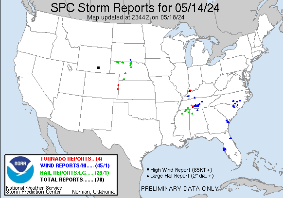
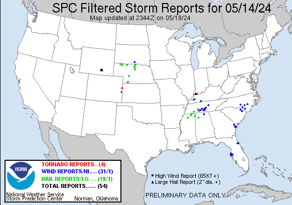
| Tornado Reports (CSV) (Raw Tornado CSV)(?) |
|---|
Time | | Location | County | State | Lat | Lon | Comments |
| 2116 | | 3 NNE Ethridge | Lawrence | TN | 3535 | 8728 | An EF-0 tornado touched down on Paige Road north of Ethridge and moved eastward along E Edan Rd and Marcella Falls Rd before lifting near the Giles County line. Damage (OHX) |
| 2137 | | 8 S Kanorado | Sherman | KS | 3922 | 10205 | [Landspout] Report and photo via social media. Photo was taken from the CO/KS stateline and Co Rd 57 ... looking south approx. 1 mile. (GLD) |
| 2155 | | 16 S Arapahoe | Cheyenne | CO | 3862 | 10220 | [Landspout] Delayed report relayed via NWS PUB. Brief landspouts reported. Original reporter could not tell if they occurred in Kiowa or Cheyenne County. Landspouts we (GLD) |
| 2214 | | 1 NE Newburgh | Warrick | IN | 3796 | 8738 | A brief EF-1 tornado with estimated peak winds of 94 mph struck the northeast side of Newburgh ... IN. The great majority of the damage was from uprooted trees and downe (PAH) |
| Hail Reports (CSV) (Raw Hail CSV)(?) |
|---|
Time | Size | Location | County | State | Lat | Lon | Comments |
| 1910 | 100 | 1 NNW Ripley | Tippah | MS | 3474 | 8895 | (MEG) |
| 1913 | 100 | 7 ENE Walnut | Alcorn | MS | 3499 | 8879 | (MEG) |
| 1920 | 100 | 6 WSW Abbeville | Lafayette | MS | 3445 | 8959 | (MEG) |
| 1955 | 100 | 1 S Crump | Hardin | TN | 3522 | 8832 | Quarter size hail in Crump. (MEG) |
| 2044 | 100 | Princeton | Caldwell | KY | 3711 | 8788 | quarter sized hail south of Princeton. (PAH) |
| 2047 | 100 | 2 SE Hohenwald | Lewis | TN | 3552 | 8753 | Report from mPING: Quarter (1.00 in.). (OHX) |
| 2110 | 100 | 1 NNW Belmont | Tishomingo | MS | 3451 | 8821 | (MEG) |
| 2117 | 100 | 17 NNW Rushville | Sheridan | NE | 4294 | 10259 | Public report of accumulating hail ... with quarter sized being the largest. (LBF) |
| 2148 | 100 | 4 W Gordon | Sheridan | NE | 4281 | 10228 | Spotter reported a few quarter sized hail stones. Time estimate from radar. (LBF) |
| 2205 | 125 | 6 S Eli | Cherry | NE | 4285 | 10144 | (LBF) |
| 2205 | 100 | 6 S Eli | Cherry | NE | 4286 | 10144 | Ground is white with hail ... largest stone approx. quarter sized. (LBF) |
| 2215 | 100 | 2 WNW Trenton | Hitchcock | NE | 4019 | 10106 | Report and photo via social media of 1 inch hail. (GLD) |
| 2217 | 175 | 8 SSW Cody | Cherry | NE | 4282 | 10131 | Public report of golf ball sized hail Time estimated from radar. (LBF) |
| 2225 | 125 | 4 WNW Trenton | Hitchcock | NE | 4020 | 10108 | Delayed report via social media. Time estimated via radar. (GLD) |
| 2237 | 100 | 3 W Trenton | Hitchcock | NE | 4018 | 10108 | Corrects previous hail report from 3 W Trenton. Spotter reports hail started as pea size ... becoming nickel to quarter size. Hail lasted approx. 10-15 minutes. (GLD) |
| 2245 | 100 | 1 W Trenton | Hitchcock | NE | 4017 | 10103 | Report and photo via social media of 1 inch hail 1 mile west of Trenton ... between 445-450 PM MDT. (GLD) |
| 2249 | 100 | Trenton | Hitchcock | NE | 4018 | 10101 | Report and photo of 1 inch hail in Trenton. (GLD) |
| 2250 | 125 | 2 E Trenton | Hitchcock | NE | 4017 | 10098 | Report and photo via social media of half dollar size hail. Time estimated from radar. (GLD) |
| 2323 | 100 | 1 NW Needmore | Winston | AL | 3426 | 8761 | Social media photos of quarter size hail near Haleyville. Location approximate. (BMX) |
| 0105 | 175 | 7 NW Bassett | Rock | NE | 4266 | 9963 | Fire department reported hail ranging from quarter to golf ball sized. (LBF) |
| 0112 | 100 | 6 SE Long Pine | Rock | NE | 4247 | 9962 | Brief period of quarter size hail. Time estimated from radar. (LBF) |
| 0115 | 100 | 6 NNE Bassett | Rock | NE | 4266 | 9949 | Public report of quarter sized hail and smaller. Time estimated from radar. (LBF) |
| 0119 | 100 | 4 ESE Burton | Keya Paha | NE | 4289 | 9952 | Nickel to quarter sized hail ... heavy rain creating ponding and runoff on driveway. (LBF) |
| 0140 | 175 | 1 S Rose | Rock | NE | 4216 | 9953 | Report via Slack chat. Time estimated from radar. (LBF) |
| 0148 | 293 | Evansville | Vanderburgh | IN | 3798 | 8754 | 2.93 inches cumulative rainfall from trained spotter on the southeast side of Evansville produced local street and yard flooding. (PAH) |
| 0213 | 100 | 1 W North Platte | Lincoln | NE | 4114 | 10080 | Report from mPING: Quarter (1.00 in.). (LBF) |
| 0217 | 125 | 1 E North Platte | Lincoln | NE | 4113 | 10075 | Time estimated from radar. (LBF) |
| 0221 | 100 | 1 SE North Platte | Lincoln | NE | 4112 | 10076 | (LBF) |
| 0223 | 100 | 4 E North Platte | Lincoln | NE | 4113 | 10069 | Mostly nickel sized hail with quarters mixed in at the NWS Office. (LBF) |
| Wind Reports (CSV) (Raw Wind CSV)(?) |
|---|
Time | Speed | Location | County | State | Lat | Lon | Comments |
| 1315 | UNK | 1 W Thunderbolt | Chatham | GA | 3204 | 8107 | Tree down on powerline. (CHS) |
| 1319 | UNK | 5 N Burroughs | Chatham | GA | 3204 | 8126 | Tree down blocking roadway. (CHS) |
| 1320 | UNK | 2 SW Savannah | Chatham | GA | 3203 | 8112 | Tree down on roadway. (CHS) |
| 1321 | UNK | 1 SE Savannah | Chatham | GA | 3204 | 8107 | Tree down blocking access to a church. (CHS) |
| 1321 | UNK | 2 NNW Savannah | Chatham | GA | 3207 | 8110 | Power line down at 411 Whitaker St. (CHS) |
| 1323 | UNK | 2 WSW Pooler | Chatham | GA | 3211 | 8128 | Lightning strike on commercial building. (CHS) |
| 1340 | UNK | 3 E Springfield | Effingham | GA | 3238 | 8133 | Tree down at intersection of Old Tusculum Rd and Standard Lane. (CHS) |
| 1515 | 60 | 1 NW Tarpon Springs | Pinellas | FL | 2816 | 8277 | A mesonet site reported 60 mph wind gust. (TBW) |
| 1520 | UNK | 1 S Largo | Pinellas | FL | 2789 | 8278 | Largo Fire Department and Pinellas Emergency Management reported 15 buildings damaged ... of which 7 were uninhabitable ... at Pointe West Mobile Home Park. Time estimate (TBW) |
| 1530 | 64 | 2 ESE Palm Harbor | Pinellas | FL | 2808 | 8273 | A mesonet site in Palm Harbor reported 64 mph wind gust. (TBW) |
| 1540 | 59 | 1 W Tampa International | Hillsborough | FL | 2798 | 8253 | Mesonet station 1829W Fswn Tampa International Airport. (TBW) |
| 2025 | UNK | 2 NNE Eddyville | Lyon | KY | 3710 | 8807 | A couple of trees down ... one on a house in Eddyville. (PAH) |
| 2040 | UNK | 3 NW Brownsville | Marlboro | SC | 3443 | 7963 | Long path of trees downed and snapped. Possible tornado. (ILM) |
| 2101 | UNK | 2 E Taylortown | Moore | NC | 3521 | 7946 | Two trees down on Longleaf Dr. East. Time estimated from radar. (RAH) |
| 2102 | UNK | 1 ESE Southern Pines | Moore | NC | 3518 | 7939 | Duke Energy outage caused by fallen trees or limbs damaging equipment. (RAH) |
| 2109 | UNK | 3 W Ethridge | Lawrence | TN | 3532 | 8735 | Large tree blocking north bound lane of TN 242. 2535 Buffalo Road. (OHX) |
| 2114 | UNK | 3 NE Ethridge | Lawrence | TN | 3535 | 8726 | Reports of multiple barns destroyed on East Edan Road ... northeast of Ethridge. (OHX) |
| 2119 | UNK | 3 NE Ethridge | Lawrence | TN | 3535 | 8727 | Large tree uprooted on East Edan Road near Ethridge. (OHX) |
| 2119 | UNK | 4 NE Ethridge | Lawrence | TN | 3536 | 8725 | Multiple large uprooted trees on Jap Lane. (OHX) |
| 2120 | UNK | 4 NE Ethridge | Lawrence | TN | 3537 | 8726 | House with roof damage. (OHX) |
| 2127 | UNK | 7 W Lynnville | Giles | TN | 3538 | 8713 | Facebook photos show a farm was damaged on Smith Hollow Rd at Campbellsville Pike with a silo falling into a swimming pool and several trees blown down. (OHX) |
| 2156 | UNK | 6 NNW Lewisburg | Marshall | TN | 3553 | 8682 | Tree on hwy. (OHX) |
| 2200 | UNK | Marion | Marion | SC | 3418 | 7940 | Windows blown out ... roofs collapsed and multiple trees down along and near Main St by possible tornado. Time estimated by radar. (ILM) |
| 2200 | UNK | 3 SE Lewisburg | Marshall | TN | 3542 | 8674 | Tree down on Snake Creek Road. (OHX) |
| 2200 | UNK | 4 W Lewisburg | Marshall | TN | 3545 | 8686 | Tree down on Webb Road. (OHX) |
| 2205 | UNK | 4 SSE Red Springs | Robeson | NC | 3476 | 7916 | Roof damage and trees down from possible tornado. Time estimated from radar. (ILM) |
| 2213 | UNK | 1 NE Newburgh | Warrick | IN | 3795 | 8740 | Several large tree limbs down at Sharon Road and Kenwood Drive. Time estimated from radar. (PAH) |
| 2223 | UNK | 6 E Petersburg | Moore | TN | 3532 | 8653 | A downed power line was reported by Moore County EMA at the intersection of Shelbyville HWY and Charity Rd. (HUN) |
| 2225 | UNK | 2 SSE Lynchburg | Moore | TN | 3526 | 8634 | Report from broadcast media of a tree down on Tanyard Hill Rd in Moore County ... TN. (HUN) |
| 2227 | UNK | 3 NNW Lynchburg | Moore | TN | 3532 | 8637 | Report of a tree down across Flat Creek HWY from Moore County EMA. (HUN) |
| 2235 | UNK | 3 NW Normandy | Bedford | TN | 3548 | 8630 | Tree down on Hwy 269. (OHX) |
| 2236 | UNK | 2 SSE Normandy | Coffee | TN | 3543 | 8624 | Tree down on Cascade Hollow Road. (OHX) |
| 2237 | UNK | Normandy | Bedford | TN | 3545 | 8626 | Trees down on Normandy Road in Normandy and along Highway 269 south of Normandy. (OHX) |
| 2240 | UNK | 2 ESE Normandy | Coffee | TN | 3544 | 8622 | Coffee County Highway Dept reported trees down blocking several roads in the southwest part of the county including Riley Creek Road ... Cedar Point Road ... and Oak Hill (OHX) |
| 2257 | UNK | 3 NNE Cedar Creek | Cumberland | NC | 3499 | 7874 | Tree reported down and blocking Carl Freeman Rd. near the intersection of NC Hwy 210. Time estimated by radar. (RAH) |
| 2302 | UNK | 3 SW Corinth | Logan | KY | 3675 | 8683 | Delayed report. Several trees down near Berea Church Road. (LMK) |
| 2305 | UNK | 4 WNW Morrison | Coffee | TN | 3562 | 8599 | Coffee County Highway Department reported trees down blocking several roads in eastern parts of the county including Casey Road and Bell Road. (OHX) |
| 2320 | UNK | 4 ESE Huntsville | Madison | AL | 3468 | 8656 | Tree down on home. (HUN) |
| 2349 | UNK | 6 E Evergreen | Columbus | NC | 3442 | 7880 | County EM reported 4 houses damaged on Red Store Rd near Old Lumberton Rd from a possible tornado. Time estimated by radar. (ILM) |
| 2355 | UNK | Sparta | White | TN | 3593 | 8547 | Scattered trees and power poles down across the county. (OHX) |
| 0012 | UNK | 2 N Turkey | Sampson | NC | 3502 | 7819 | Tree down near the intersection of Cabin Museum Rd. and Old Warsaw Rd. (RAH) |
| 0035 | 58 | 4 NNE Colome | Tripp | SD | 4331 | 9969 | (UNR) |
| 0102 | 81 | 7 NW Elk Mountain | Carbon | WY | 4175 | 10652 | From WY18 Halleck Ridge Wind Sensor. (CYS) |
| 0652 | UNK | 5 SW Espanola | Flagler | FL | 2946 | 8137 | Power outage Mondex about 10 miles west of Bunnell. (JAX) |
| 0742 | UNK | Flagler Beach | Flagler | FL | 2947 | 8113 | Power outage reported for south Flagler Beach. (JAX) |


 @NWSSPC