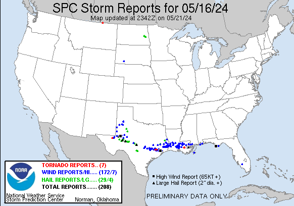
| Tornado Reports (CSV) (Raw Tornado CSV)(?) |
|---|
Time | | Location | County | State | Lat | Lon | Comments |
| 2030 | | 9 S Mentone | Reeves | TX | 3157 | 10359 | [Landspout] Video relayed by media. (MAF) |
| 2212 | | 18 NE Whitewater | Phillips | MT | 4894 | 10735 | [Landspout] (GGW) |
| 2215 | | 16 N Whitewater | Phillips | MT | 4894 | 10735 | [Landspout] Corrects previous landspout report from 18 NE Whitewater. (GGW) |
| 2244 | | 5 SSE Pine Island | Waller | TX | 2999 | 9599 | Large metal barn destroyed ... Trailers rolled. Metal debris strewn 1000 yards to SE. Tree fall in multiple directions ranging from S to NW. (HGX) |
| 2308 | | 4 SSW Cypress | Harris | TX | 2992 | 9570 | Tornado touched down near intersection of Tuckerton and Greenhouse Roads then tracked southeastward through Highlands subdivision. Numerous single family homes had roof (HGX) |
| 0346 | | 5 NW Convent | St. James | LA | 3007 | 9089 | NWS Storm Survey team determined an EF-1 tornado ... with a peak wind of 105 mph and a maximum width of 120 yards ... impacted Romeville in St. James Parish. This tornado (LIX) |
| 0351 | | 3 NNW Convent | St. James | LA | 3006 | 9085 | Multiple reports of trees and power poles down. CC drop detected on radar as well. (LIX) |
| Hail Reports (CSV) (Raw Hail CSV)(?) |
|---|
Time | Size | Location | County | State | Lat | Lon | Comments |
| 1740 | 100 | 1 W Snyder | Scurry | TX | 3271 | 10093 | Report from mPING: Quarter (1.00 in.). (MAF) |
| 1743 | 175 | Snyder | Scurry | TX | 3271 | 10092 | (MAF) |
| 1821 | 100 | 2 WSW Lake Alan Henry | Garza | TX | 3306 | 10108 | Observed on live-streaming webcam. Mostly dime to nickel size with a few quarter size stones. (LUB) |
| 1931 | 100 | 1 NE Broaddus | San Augustine | TX | 3132 | 9425 | A picture was posted to social media of quarter size hail that fell near Broaddus. (SHV) |
| 2124 | 100 | 5 WNW Livingston | Polk | TX | 3074 | 9502 | County dispatch reported 1 inch hail over Diamond Lil Strip. (HGX) |
| 2155 | 300 | 10 NNW Texon | Reagan | TX | 3136 | 10177 | 3 inch diameter hail measured ... photo via Twitter/X. (MAF) |
| 2200 | 125 | 4 W Stiles | Reagan | TX | 3141 | 10163 | Public photo shared of half dollar size hail. (MAF) |
| 2239 | 100 | West Odessa | Ector | TX | 3184 | 10250 | multiple observations of quarter sized hail in West Odessa. (MAF) |
| 2242 | 250 | 3 WNW Odessa | Ector | TX | 3188 | 10242 | Time estimated by radar. (MAF) |
| 2250 | 175 | Odessa | Ector | TX | 3185 | 10237 | golf ball sized hail observed at University and Grandview in Odessa. (MAF) |
| 2257 | 100 | 2 SW Mission Dorado | Ector | TX | 3189 | 10230 | Report from mPING: Quarter (1.00 in.). (MAF) |
| 2305 | 275 | 6 N Barnhart | Irion | TX | 3122 | 10118 | (SJT) |
| 2312 | 100 | 5 W Midland | Midland | TX | 3200 | 10217 | Hail ranged from half inch to quarter size at SH191 and Avalon. (MAF) |
| 2314 | 150 | 11 WSW Mertzon | Irion | TX | 3118 | 10098 | (SJT) |
| 2315 | 125 | 4 WNW Cotton Flat | Midland | TX | 3195 | 10212 | Photo showing approximately half dollar size hail. (MAF) |
| 2317 | 100 | Crane | Crane | TX | 3139 | 10235 | (MAF) |
| 2343 | 100 | 15 NNW Eldorado | Schleicher | TX | 3105 | 10074 | (SJT) |
| 2352 | 100 | 4 SW Christoval | Tom Green | TX | 3116 | 10056 | (SJT) |
| 2357 | 125 | 1 SW Rankin | Upton | TX | 3122 | 10195 | Report from mPING: Half Dollar (1.25 in.). (MAF) |
| 0000 | 100 | 1 S Buna | Jasper | TX | 3043 | 9396 | Corrects previous hail report from 1 S Buna. Public photo of quarter size hail in Buna. Time estimated by radar. (LCH) |
| 0101 | 100 | 1 WNW Menard | Menard | TX | 3093 | 9981 | COOP Observer reported quarter size hail and 50 mph winds just south of the Menard Airport at 8:01 PM. (SJT) |
| 0102 | 125 | 2 N Menard | Menard | TX | 3094 | 9978 | Report from mPING: Half Dollar (1.25 in.). (SJT) |
| 0118 | 150 | 4 W Hext | Menard | TX | 3087 | 9960 | (SJT) |
| 0150 | 200 | Mason | Mason | TX | 3075 | 9924 | Golf ball and larger hail across Mason. (SJT) |
| 0215 | 100 | 2 N Luverne | Steele | ND | 4728 | 9793 | 1 inch hail reported 2 miles north of Luverne ND. (FGF) |
| 0240 | 100 | Pillsbury | Barnes | ND | 4721 | 9779 | Delayed report from social media ... Time estimated from radar. (FGF) |
| 0324 | 100 | Page | Cass | ND | 4716 | 9757 | Delayed report ... relayed via media. (FGF) |
| 0445 | 175 | Medina | Bandera | TX | 2980 | 9925 | 2 minutes of hail with max size of golfballs. (EWX) |
| 0500 | 125 | Bandera | Bandera | TX | 2973 | 9907 | Picture of half dollar sized hail. (EWX) |
| Wind Reports (CSV) (Raw Wind CSV)(?) |
|---|
Time | Speed | Location | County | State | Lat | Lon | Comments |
| 1745 | UNK | Immokalee | Collier | FL | 2642 | 8144 | Pictures on social media of damage left behind after strong thunderstorm. Medium-large tree limbs broken ... power line poles down ... tents blown over. (MFL) |
| 1745 | UNK | 1 ENE Immokalee | Collier | FL | 2643 | 8142 | Corrects previous tstm wnd dmg report from 1 ENE Immokalee. Several downed trees and powerlines across Immokalee. Tree down at South 9th and Palmetto Ave blocking entir (MFL) |
| 1940 | UNK | 6 N Hemphill | Sabine | TX | 3143 | 9385 | Numerous power outages in Milam ... TX. (SHV) |
| 2115 | UNK | 4 WNW Tanglewood Forest | Travis | TX | 3019 | 9790 | 6+ inch diameter tree snapped in Circle C Neighborhood in South Austin. (EWX) |
| 2115 | UNK | 5 W Livingston | Polk | TX | 3070 | 9502 | Fallen Trees and home damage reported along Wolf Run road. (HGX) |
| 2120 | UNK | 4 W Bastrop | Bastrop | TX | 3011 | 9737 | Damage to a carport ... tossed and mangled and partially removed roof damage to a barn in west Bastrop. Time approximated via radar. (EWX) |
| 2126 | UNK | Woodville | Tyler | TX | 3078 | 9442 | Tyler county 911 reported powerlines down and power outages occurred across the county with the storms passage. (LCH) |
| 2127 | UNK | 4 SSW Wells Branch | Travis | TX | 3039 | 9770 | Large tree down in north Austin via Slack. (EWX) |
| 2131 | UNK | 1 SE Jollyville | Travis | TX | 3044 | 9774 | Large tree down over the road at McNeil and Parmer in north Austin. (EWX) |
| 2135 | 68 | 3 N Plains | Yoakum | TX | 3323 | 10284 | West Texas Mesonet. Also gusted to 59 mph from 4:36 to 4:37 PM. (LUB) |
| 2145 | UNK | 9 S Giddings | Fayette | TX | 3006 | 9691 | Delayed social media report of downed trees ... several large tree limbs ... and minor cosmetic damage within the town of Warda. (EWX) |
| 2145 | UNK | 5 SW Lincoln | Lee | TX | 3023 | 9702 | Report relayed via the public from NWS HGX of wind damage and numerous trees limbs down along Highway 21 and Private Rd 80 northwest of Giddings. (EWX) |
| 2145 | UNK | 6 NNW New Waverly | Walker | TX | 3061 | 9552 | Trees down on roadways. (HGX) |
| 2155 | UNK | 5 W Bastrop | Bastrop | TX | 3012 | 9738 | Report from mPING 3-inch tree limbs broken; Power poles broken. (EWX) |
| 2157 | UNK | 4 ENE Round Top | Fayette | TX | 3009 | 9664 | Damage to a barn as well as a flipped RV near Winedale off FM 2714. (EWX) |
| 2200 | UNK | 4 W Carmine | Fayette | TX | 3012 | 9675 | Report from mPING Trees uprooted or snapped; Roof blown off. (EWX) |
| 2210 | UNK | 9 SE Burton | Washington | TX | 3008 | 9651 | Trees down. Funnel cloud sighted ... possible tornado. Near Wesley. (HGX) |
| 2213 | UNK | Jasper | Jasper | TX | 3092 | 9400 | Jasper county 911 reports multiple power outages and power lines down across the county with the storms passage. (LCH) |
| 2213 | 61 | 6 NNW Levelland | Hockley | TX | 3366 | 10240 | (LUB) |
| 2215 | UNK | La Grange | Fayette | TX | 2991 | 9688 | Numerous reports of wind damage in addition to power outages in Fayette County ... including the city of La Grange. (EWX) |
| 2215 | UNK | 1 W Notrees | Ector | TX | 3192 | 10277 | Photo shared of a collapsed radio tower near Notrees. Time is estimated from radar. Wind speeds are estimated to have been approximately 110-120 MPH. (MAF) |
| 2219 | UNK | 8 SW Paynes Corner | Gaines | TX | 3263 | 10288 | Seminole Fire Department reported power lines down at CR316 and CR327. (MAF) |
| 2223 | UNK | 1 W Round Top | Fayette | TX | 3006 | 9670 | Report from mPING 1-inch tree limbs broken; Shingles blown off. (EWX) |
| 2229 | UNK | 2 SE La Grange | Fayette | TX | 2989 | 9685 | Report from mPING 3-inch tree limbs broken; Power poles broken. (EWX) |
| 2230 | UNK | 2 NE Bellville | Austin | TX | 2997 | 9624 | Trees down ... metal roofs blown off. (HGX) |
| 2245 | UNK | Pine Island | Waller | TX | 3006 | 9603 | Trees down. Social media. (HGX) |
| 2245 | UNK | 1 NE Prairie View | Waller | TX | 3009 | 9598 | Trees down. (HGX) |
| 2250 | 71 | 1 (LC | ) | | | | |
| 2250 | 71 | 1 SW College Station | Brazos | TX | 3061 | 9634 | Mesonet station 1757W Texas A&m Kyle Field. (HGX) |
| 2251 | 65 | 6 NE Odessa | Ector | TX | 3192 | 10230 | Estimated 60 to 70 mph wind gusts at Billy Hext and SH 191. (MAF) |
| 2253 | 64 | 3 NW Wink | Winkler | TX | 3178 | 10320 | ASOS station KINK Wink. (MAF) |
| 2255 | UNK | 8 SSW Waller | Waller | TX | 2994 | 9595 | Roof damage to newly built home. (HGX) |
| 2255 | UNK | 8 SSE De Ridder | Beauregard | LA | 3075 | 9324 | Powerlines and power poles blown down along portions of hwy 171 south of Deridder. Time estimated from radar. (LCH) |
| 2256 | 63 | 4 NNE Shallowater | Lubbock | TX | 3374 | 10197 | West Texas Mesonet. (LUB) |
| 2258 | 69 | 1 NNE Hempstead | Waller | TX | 3011 | 9608 | Mesonet station 030HC 4650 Hwy 6 At Sh290. (HGX) |
| 2300 | UNK | 1 S Katy | Harris | TX | 2979 | 9582 | Trees downed. (HGX) |
| 2300 | UNK | 4 E Waller | Harris | TX | 3006 | 9586 | Roof damage Kermier Rd and Pine Tree Lane. Debris multiple directions. (HGX) |
| 2300 | 60 | 10 WNW Pyote | Ward | TX | 3160 | 10327 | Mesonet station FW9693 Pyote. (MAF) |
| 2302 | UNK | 4 S Sam Rayburn Dam | Jasper | TX | 3101 | 9410 | Numerous power outages resulting from downed powerlines from trees. Time estimated by radar. (LCH) |
| 2303 | 59 | 1 NNW Lubbock Int. Airp | Lubbock | TX | 3367 | 10182 | ASOS station KLBB Lubbock Intl Airport. (LUB) |
| 2310 | UNK | 7 SW Cypress | Harris | TX | 2990 | 9576 | Transmission lines down. (HGX) |
| 2310 | UNK | 6 WNW Honey Island | Hardin | TX | 3041 | 9453 | Corrects previous flash flood report from 6 WNW Honey Island. HAM reports large tree down across FM 1293 in Honey Island. Time estimated by radar. (LCH) |
| 2310 | UNK | 4 N Longville | Beauregard | LA | 3067 | 9324 | Utility company reports numerous power outages across Beauregard parish. Trees down on power lines and power poles blown down. (LCH) |
| 2315 | UNK | Jersey Village | Harris | TX | 2989 | 9557 | Multiple trees down. (HGX) |
| 2315 | 65 | 5 WSW Cypress | Harris | TX | 2995 | 9574 | Mesonet station CW9236 Cypress. (HGX) |
| 2315 | 70 | 5 NNW Mission Dorado | Ector | TX | 3198 | 10230 | Mesonet station FW9685 Odessa. (MAF) |
| 2320 | UNK | 2 S Midland | Midland | TX | 3197 | 10207 | Storm chaser sent a photo of a gas station canopy destroyed. (MAF) |
| 2323 | UNK | 3 N Odessa | Ector | TX | 3189 | 10238 | Large tree uprooted near Sherwood Park. (MAF) |
| 2325 | UNK | 3 NNE Odessa | Ector | TX | 3190 | 10236 | Large tree uprooted and street light taken down by high winds. (MAF) |
| 2326 | 71 | 5 NNW Odessa | Ector | TX | 3192 | 10240 | ASOS station KODO Odessa. (MAF) |
| 2327 | 58 | 1 S Plainview | Hale | TX | 3418 | 10171 | West Texas Mesonet. (LUB) |
| 2328 | 76 | 1 NW Midland Internatio | Midland | TX | 3195 | 10220 | ASOS station KMAF Midland. (MAF) |
| 2330 | UNK | 3 N Houston | Harris | TX | 2981 | 9539 | *** 4 FATAL *** 4 confirmed fatalities and 1 unconfirmed fatality across different locations across the Houston metro area from fallen trees and a crane incident. (HGX) |
| 2330 | UNK | 4 SSE Aldine | Harris | TX | 2986 | 9536 | Large trees down I45 & Parker Rd. (HGX) |
| 2330 | 60 | 2 S Plainview | Hale | TX | 3417 | 10172 | AWOS station KPVW Hale County Airport. (LUB) |
| 2335 | UNK | 1 WNW Mission Dorado | Ector | TX | 3192 | 10229 | Rosas Cafe sign blown apart. (MAF) |
| 2335 | 59 | 3 NNW Midland | Midland | TX | 3203 | 10210 | AWOS station KMDD Midland Airpark. (MAF) |
| 2339 | UNK | 4 W Jacinto City | Harris | TX | 2977 | 9531 | Multiple trees down. Denver Harbor area. (HGX) |
| 2341 | UNK | 2 NE Jacinto City | Harris | TX | 2978 | 9522 | Widespread trees downed across the area. Homes damaged throughout the neighborhood. (HGX) |
| 2343 | UNK | 1 SE Houston | Harris | TX | 2976 | 9537 | Numerous windows blown out downtown skyscrapers. (HGX) |
| 2343 | UNK | 2 SSW Evadale | Jasper | TX | 3031 | 9408 | Photo of tree blown down on a powerline south of Evadale. Time estimated from radar. (LCH) |
| 2345 | 62 | 6 N Aldine | Harris | TX | 3000 | 9537 | ASOS station KIAH Houston Intnl. (HGX) |
| 2345 | UNK | 1 ESE Mission Dorado | Midland | TX | 3191 | 10225 | Multiple areas of wind damage including billboards blown apart and a radio tower collapsed along Bus 20. (MAF) |
| 2348 | UNK | 2 ESE Greenwood | Midland | TX | 3202 | 10187 | Small shed blown away and dumpster tipped over. (MAF) |
| 2351 | UNK | 2 NE Evadale | Jasper | TX | 3036 | 9404 | Numerous power poles and trees knocked down or snapped off. (LCH) |
| 2352 | 59 | 3 NW Greenwood | Midland | TX | 3207 | 10194 | Mesonet station UR098 3.3 NW Greenwood (UPR). (MAF) |
| 2353 | UNK | 6 SSW Oakdale | Allen | LA | 3074 | 9270 | Photo of numerous power poles snapped off on Hwy 165 from storms south of Oakdale. Time estimated by radar. (LCH) |
| 2354 | 63 | 1 N Deer Park | Harris | TX | 2971 | 9512 | Mesonet station PTKT2 650 Patricks Bayou At East 8th S. (HGX) |
| 2354 | 66 | 5 SW Saint Lawrence | Glasscock | TX | 3166 | 10160 | Mesonet station 55 5SW St. Lawrence ... TX. (MAF) |
| 2355 | 71 | 2 E West University Pla | Harris | TX | 2972 | 9540 | AWOS station KMCJ Houston Univ. (HGX) |
| 2356 | UNK | 5 ENE Bleakwood | Newton | TX | 3072 | 9375 | Report of tree down on FM 363 and Lewis Chapel. Time estimated from radar. (LCH) |
| 2357 | UNK | 1 SSE Buna | Jasper | TX | 3043 | 9396 | Power pole snapped off by the storm was replaced in downtown Buna. Time estimated by radar. (LCH) |
| 2357 | UNK | Oberlin | Allen | LA | 3062 | 9277 | Report of a tree down along hwy 26 south of Oberlin. (LCH) |
| 2359 | UNK | Gist | Jasper | TX | 3027 | 9391 | Report of tree down on the southbound land of hwy 62 near the New Cherry Grove Baptist Church. Time estimated from radar. (LCH) |
| 0000 | 62 | 4 NNE Brookside Village | Harris | TX | 2963 | 9528 | ASOS station KHOU Houston Hobby. (HGX) |
| 0000 | UNK | 3 SW Baytown | Harris | TX | 2972 | 9500 | Numerous trees and power lines down. (HGX) |
| 0000 | UNK | 1 WSW Buna | Jasper | TX | 3044 | 9397 | Public video of siding damage to Cougar Stop in Buna ... TX. Time estimated by radar. (LCH) |
| 0000 | UNK | 2 W Midland | Midland | TX | 3201 | 10212 | Report from mPING: 1-inch tree limbs broken; Shingles blown off. (MAF) |
| 0001 | 78 | 1 S Highlands | GMZ335 | TX | 2979 | 9506 | Mesonet station HLNT2 G103 San Jacinto River At I-10 E. (HGX) |
| 0002 | 74 | 3 SE Channelview | Harris | TX | 2976 | 9508 | Mesonet station SCPT2 2200 Houston Ship Channel At Jua. (HGX) |
| 0003 | 59 | Midland International | Midland | TX | 3194 | 10219 | Mesonet station MNDT2 Midland. (MAF) |
| 0005 | 78 | 2 SE Channelview | GMZ335 | TX | 2976 | 9508 | Multiple ships along the upper Houston Ship Channel have either broken away or are currently being supported by tugs. A pollution incident is reported at Kavavnaugh Doc (HGX) |
| 0007 | UNK | 2 WSW Cove | Chambers | TX | 2980 | 9485 | Wind blew back part of roof at Chambers County EMS in Cove. Time estimated by radar. (HGX) |
| 0010 | UNK | 1 WSW Saratoga | Hardin | TX | 3028 | 9454 | Large trees blow down across FM 770 about 1 mile west of Saratoga TX. Several power lines down in the same area as well. (LCH) |
| 0011 | UNK | 2 S Midland | Midland | TX | 3197 | 10207 | Report from mPING: Trees uprooted or snapped; Roof blown off. (MAF) |
| 0012 | UNK | 6 NNW Starks | Calcasieu | LA | 3039 | 9370 | Power outages reported near Old River rd due to downed power lines. (LCH) |
| 0015 | 62 | Morgan's Point | Harris | TX | 2968 | 9501 | Mesonet station 9221D Morgan's Point. (HGX) |
| 0015 | 63 | 3 SE Baytown | Chambers | TX | 2972 | 9494 | Mesonet station CBHT2 1710 Cedar Bayou At Sh 99. (HGX) |
| 0020 | UNK | 7 N Starks | Beauregard | LA | 3042 | 9369 | Numerous power outages reported north of Starks near Smith Cemetery rd due to downed powerlines. (LCH) |
| 0020 | UNK | 8 ESE Call | Newton | TX | 3055 | 9376 | Numerous power outages resulting from downed power lines and trees. Time estimated by radar. (LCH) |
| 0022 | UNK | 4 N Starks | Calcasieu | LA | 3037 | 9367 | Public report of trees down along hwy 109 near the Starks community. (LCH) |
| 0025 | UNK | 4 WSW Silsbee | Hardin | TX | 3032 | 9424 | Fire dept working an area of downed power lines southwest of Silsbee. (LCH) |
| 0025 | 65 | 3 NW Forsan | Howard | TX | 3214 | 10140 | Tree limbs down. (MAF) |
| 0033 | UNK | 5 ENE Pine Prairie | Evangeline | LA | 3082 | 9235 | Photo of large tree down in Bayou Chicot. Time estimated by radar when a hail core was descending out of storm. (LCH) |
| 0034 | UNK | 4 ENE Kountze | Hardin | TX | 3040 | 9425 | Fire department working power lines down between Kountze and Silsbee. (LCH) |
| 0040 | 70 | Sterling City | Sterling | TX | 3184 | 10099 | Estimated 70+ mph winds at Sterling City. (SJT) |
| 0045 | UNK | 3 NNE Sterling City | Sterling | TX | 3188 | 10096 | Tin roof blown off a structure along Highway 158 northeast of Sterling City. (SJT) |
| 0050 | 60 | Kyle | Oglala Lakota | SD | 4342 | 10218 | pea sized hail (UNR) |
| 0052 | UNK | 1 E De Quincy | Calcasieu | LA | 3045 | 9343 | Photo of large oak tree blown down on front street in De Quincy. Time estimated from radar. (LCH) |
| 0052 | UNK | 5 ENE De Quincy | Beauregard | LA | 3047 | 9337 | Tree fell on Reneau Rd northeast of De Quincy. Time estimated from radar. (LCH) |
| 0100 | UNK | 2 NW Menard | Menard | TX | 3093 | 9981 | Measured gust to 81 mph by the Menard West Texas Mesonet station. (SJT) |
| 0102 | UNK | 3 SW Gillis | Calcasieu | LA | 3034 | 9323 | Report of tree down on Perkins Ferry Rd just north of Joe Miller Rd. Time estimated by radar. (LCH) |
| 0154 | UNK | 1 NNE Kinder | Allen | LA | 3050 | 9284 | 911 center reports large swath of powerlines blown down near Kinder. (LCH) |
| 0206 | UNK | 3 SSE Pitkin | Vernon | LA | 3090 | 9292 | Utility company reports damage to the transmission lines service substations for Elizabeth ... Pitkin and Sugartown. (LCH) |
| 0215 | 59 | 3 NE Crowley | Acadia | LA | 3025 | 9235 | Mesonet station LSU03 Crowley. (LCH) |
| 0215 | UNK | Mire | Acadia | LA | 3030 | 9220 | Public reports large oak limb was blown down onto power lines. (LCH) |
| 0215 | 62 | 2 NW New Roads | Pointe Coupee | LA | 3072 | 9148 | AWOS station KHZR New Roads. (LIX) |
| 0224 | UNK | 2 S Cankton | Lafayette | LA | 3031 | 9212 | Numerous large branches snapped near Vatican. (LCH) |
| 0228 | UNK | 3 N Scott | Lafayette | LA | 3028 | 9210 | Numerous branches snapped near Ossun. (LCH) |
| 0228 | UNK | 3 W Carencro | Lafayette | LA | 3030 | 9209 | Numerous branches snapped ... some trees snapped and uprooted. (LCH) |
| 0229 | 61 | 4 WSW Maurice | Vermilion | LA | 3008 | 9218 | Personal weather station reported a gust to 61 MPH with storm passage. (LCH) |
| 0230 | 70 | 4 W Broussard | Lafayette | LA | 3016 | 9203 | Media posted a video of estimated 70 MPH wind gust. Time estimated by radar. (LCH) |
| 0230 | UNK | 1 WNW Scott | Lafayette | LA | 3024 | 9210 | Corrects previous tstm wnd dmg report from 1 WNW Scott. Public submitted a photo of an uprooted tree falling on and partially crushing a small home on St Mary St. (LCH) |
| 0230 | UNK | 2 NW Scott | Lafayette | LA | 3025 | 9211 | Branches down. (LCH) |
| 0230 | UNK | 3 NNW Carencro | Lafayette | LA | 3034 | 9206 | Large tree snapped. (LCH) |
| 0230 | UNK | 2 E Cankton | Lafayette | LA | 3035 | 9207 | Large tree snapped across roadway. (LCH) |
| 0231 | UNK | 1 NW Rayne | Acadia | LA | 3024 | 9227 | Video received of large tree down on Lyman Ave in Rayne. Time from radar. (LCH) |
| 0232 | UNK | 1 W Lafayette | Lafayette | LA | 3021 | 9205 | Report of tree down in the parking lot of Raising Canes restaurant. Time estimated by radar. (LCH) |
| 0233 | UNK | 1 WSW Lafayette | Lafayette | LA | 3021 | 9205 | Photo received of a tree snapped off in Lafayette. (LCH) |
| 0234 | 65 | 1 SSE Lafayette | Lafayette | LA | 3020 | 9202 | Call from the public about strong wind gust measured on a personal weather station. (LCH) |
| 0236 | UNK | Lafayette | Lafayette | LA | 3022 | 9203 | Public submitted photo of power poles snapped with lines and transformers attached. Time estimated by radar. (LCH) |
| 0237 | UNK | Slaughter | East Feliciana | LA | 3072 | 9114 | Multiple trees down and blocking some roads around Slaughter. (LIX) |
| 0239 | UNK | 4 SW Lafayette | Lafayette | LA | 3017 | 9207 | Report from mPING: 1-inch tree limbs broken; Shingles blown off. (LCH) |
| 0239 | UNK | 2 NNW Carencro | Lafayette | LA | 3034 | 9206 | Corrects previous flash flood report from 2 NNW Carencro. Off duty NWS employee reports multiple large tree branches down near Carencro. (LCH) |
| 0241 | UNK | 1 SSE Breaux Bridge | St. Martin | LA | 3027 | 9189 | Public photo of downed trees blocking the road. Time estimated by radar. (LCH) |
| 0241 | UNK | Sunset | St. Landry | LA | 3041 | 9207 | Corrects previous tstm wnd dmg report from Sunset. Photo received of large trees down in the Sunset community. (LCH) |
| 0246 | 67 | 4 SSE Cade | Iberia | LA | 3003 | 9188 | AWOS station KARA 4 SSE Cade. (LCH) |
| 0247 | UNK | Baker | East Baton Rouge | LA | 3059 | 9116 | Trees down in Baker. Relayed via social media. (LIX) |
| 0249 | 69 | 2 ESE Lafayette | Lafayette | LA | 3020 | 9200 | ASOS station KLFT Lafayette. (LCH) |
| 0255 | UNK | 4 WSW Parks | St. Martin | LA | 3019 | 9188 | Public reports residential window sucked out of its frame as the storm passed. Time estimated from radar. (LCH) |
| 0256 | UNK | Parks | St. Martin | LA | 3022 | 9183 | Corrects previous tstm wnd dmg report from Parks. Public reports large tree limb was blown off a tree that then hit the house. A heavy duty rabbit cage was flipped over (LCH) |
| 0256 | UNK | 2 SE Port Allen | East Baton Rouge | LA | 3043 | 9118 | Poles blown over along Highland Rd and E Polk. (LIX) |
| 0256 | UNK | 3 NW Baton Rouge | East Baton Rouge | LA | 3048 | 9116 | Tree down on a house off of Plan Rd and N. Acadian Thwy. (LIX) |
| 0257 | UNK | Saint Martinville | St. Martin | LA | 3012 | 9183 | Report from mPING: 1-inch tree limbs broken; Shingles blown off. (LCH) |
| 0257 | UNK | 3 SSW Baton Rouge | East Baton Rouge | LA | 3041 | 9115 | Tree down on Whitehaven. (LIX) |
| 0258 | UNK | 4 NE Saint Martinville | St. Martin | LA | 3016 | 9178 | Public reports roof blown off of home in St. Martinville. Time estimated by radar. (LCH) |
| 0300 | UNK | 3 SSE Breaux Bridge | St. Martin | LA | 3024 | 9188 | Public reports numerous trees blown down between Breaux Bridge and Parks. (LCH) |
| 0300 | UNK | 3 NNE Parks | St. Martin | LA | 3026 | 9182 | Public reports damage to a residence. Corner of a roof was lifted up with the storm passage. Time estimated by radar. (LCH) |
| 0301 | UNK | 1 SE Buna | Jasper | TX | 3043 | 9395 | Report from mPING: 3-inch tree limbs broken; Power poles broken. (LCH) |
| 0304 | UNK | Catahoula | St. Martin | LA | 3021 | 9171 | Public reports numerous trees and power lines down around the Catahoula community. Time estimated by radar. (LCH) |
| 0304 | UNK | Krotz Springs | St. Landry | LA | 3054 | 9176 | Local EM reports 3 homes with damage from downed trees. Time estimated by radar. (LCH) |
| 0307 | UNK | Melville | St. Landry | LA | 3069 | 9175 | EM reported numerous trees down throughout the east side of St. Landry Parish. High winds reports in Melville area along with numerous power outages. (LCH) |
| 0310 | UNK | 2 NW Carencro | Lafayette | LA | 3034 | 9206 | Report from mPING: 3-inch tree limbs broken; Power poles broken. (LCH) |
| 0310 | 60 | 3 SSE Port Allen | East Baton Rouge | LA | 3041 | 9118 | Mesonet station 1311W LSU Tiger Stadium. (LIX) |
| 0321 | UNK | Bayou Sorrel | Iberville | LA | 3016 | 9133 | Numerous downed trees in Bayou Sorrel near the Hwy 75 bridge. Time estimated from radar. (LIX) |
| 0321 | UNK | 4 SE Watson | Livingston | LA | 3054 | 9090 | Snapped power pole off of Arnold Road in Denham Springs ... LA. (LIX) |
| 0323 | UNK | 1 NE New Iberia | Iberia | LA | 3001 | 9181 | Report from mPING: 1-inch tree limbs broken; Shingles blown off. (LCH) |
| 0333 | UNK | 5 NNE Walker | Livingston | LA | 3056 | 9084 | Delayed Report: Photo of 1-3 inch tree limbs and some larger broken from severe storm winds. One additional report of a snapped pine tree. Time estimated from radar. (LIX) |
| 0351 | UNK | 2 WSW Springfield | Livingston | LA | 3042 | 9057 | Trees down and some minor structural damage. (LIX) |
| 0434 | UNK | 1 E Covington | St. Tammany | LA | 3048 | 9010 | Multiple trees down across Covington with a few blocking side streets. Widespread power outages across the city. (LIX) |
| 0435 | UNK | 2 ESE Mandeville | St. Tammany | LA | 3036 | 9005 | A few trees and large limbs down. (LIX) |
| 0436 | 84 | 1 NNW Kenner | Jefferson | LA | 2999 | 9026 | MSY ASOS measured a wind gust of 73.2 knots (84 mph). (LIX) |
| 0438 | UNK | 5 NE New Orleans | Orleans | LA | 3003 | 9003 | People trapped in overturned vehicle on France Rd. (LIX) |
| 0445 | UNK | 2 NNE Waggaman | Jefferson | LA | 2996 | 9022 | Tree blown down on a fence in River Ridge. (LIX) |
| 0453 | 82 | 6 WSW East New Orleans | Orleans | LA | 3004 | 9003 | New Orleans Lakefront Airport measured a wind gust of 82 mph. (LIX) |
| 0500 | 62 | 3 SW East New Orleans | Orleans | LA | 3003 | 8997 | NOFD Engine 36 - New Orleans East LA US WEATHERSTEM measured a wind gust of 62 mph. (LIX) |
| 0500 | UNK | 2 NNE Pearl River | St. Tammany | LA | 3040 | 8974 | Tree reported across I-59 near Pearl River. (LIX) |
| 0501 | 82 | 6 WSW East New Orleans | Orleans | LA | 3004 | 9003 | New Orleans Lakefront Airport recorded a second wind gust of 82 mph. (LIX) |
| 0506 | 72 | 6 SE East New Orleans | St. Bernard | LA | 2999 | 8987 | Bayou Bienvenue (Vertical Lift Gate) measured a wind gust of 72 mph. (LIX) |
| 0520 | UNK | 1 N Kiln | Hancock | MS | 3044 | 8943 | Fascia damage to building and roof damage to open pole barn. Time estimated by radar. (LIX) |
| 0630 | 65 | 9 SE Venice | Plaquemines | LA | 2918 | 8926 | Mesonet station PILL1 Pilottown LA measured a gust of 65 mph. (LIX) |
| 0706 | 58 | Ft Gaines | GMZ631 | AL | 3025 | 8808 | Ft Gaines NOS/COOPS site measured a marine wind gust of 58 mph. (MOB) |
| 0735 | 59 | 2 WSW Miflin | Baldwin | AL | 3036 | 8765 | WeatherFlow station (XGLF) south of Foley measured a 59 mph wind gust. (MOB) |
| 1001 | 71 | 3 SSE Saint Joseph Stat | Gulf | FL | 2975 | 8540 | Ambient station gusted to 71 mph. (TAE) |
| 1002 | 87 | 3 S Saint Joseph State | Gulf | FL | 2975 | 8540 | Ambient station gusted to 87 mph. (TAE) |
| 1006 | UNK | Port Saint Joe | Gulf | FL | 2980 | 8530 | Downed cable lines in Port St. Joe. (TAE) |
| 1007 | 62 | 1 ESE Indian Pass | Gulf | FL | 2968 | 8525 | Ambient station gusted to 62 mph. (TAE) |
| 1013 | 74 | 5 SSE Saint Joseph Stat | Gulf | FL | 2973 | 8539 | Ambient station gusted to 74 mph. (TAE) |
| 1015 | UNK | 3 S Saint Joseph State | Gulf | FL | 2975 | 8540 | Porch screens ripped apart ... Doors mechanisms torn ... Dead trees broken ... Light debris scattered. (TAE) |
| 1025 | 60 | Franklin EOC | Franklin | FL | 2972 | 8503 | Franklin EOC Weatherstem gusted to 60 mph along the coast. (TAE) |
| 1025 | 70 | Apalachicola Airport | Franklin | FL | 2973 | 8503 | (TAE) |
| 1032 | UNK | Apalachicola | Franklin | FL | 2973 | 8498 | Multiple power lines reported down across highway 98. (TAE) |


 @NWSSPC