 Note:
The expiration time in the watch graphic is amended if the watch is
replaced, cancelled or extended.
Note:
Note:
The expiration time in the watch graphic is amended if the watch is
replaced, cancelled or extended.
Note: Click for
Watch Status Reports.
SEL5
URGENT - IMMEDIATE BROADCAST REQUESTED
Severe Thunderstorm Watch Number 475
NWS Storm Prediction Center Norman OK
240 PM MDT Thu Jun 27 2024
The NWS Storm Prediction Center has issued a
* Severe Thunderstorm Watch for portions of
Eastern Colorado
Northwest Kansas
Western Nebraska
Western South Dakota
Northeast Wyoming
* Effective this Thursday afternoon and evening from 240 PM until
900 PM MDT.
* Primary threats include...
Scattered damaging winds and isolated significant gusts to 75
mph likely
Scattered large hail and isolated very large hail events to 3
inches in diameter likely
A tornado or two possible
SUMMARY...Cluster of strong to severe thunderstorms are expected to
track across the watch area this afternoon and evening. A few
supercells capable of very large hail, damaging winds, and a tornado
or two are possible.
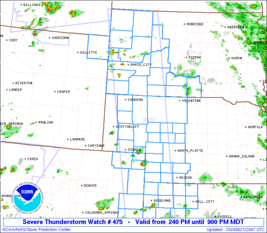
The severe thunderstorm watch area is approximately along and 60
statute miles east and west of a line from 35 miles northeast of
Buffalo SD to 45 miles south of Goodland KS. For a complete
depiction of the watch see the associated watch outline update
(WOUS64 KWNS WOU5).
PRECAUTIONARY/PREPAREDNESS ACTIONS...
REMEMBER...A Severe Thunderstorm Watch means conditions are
favorable for severe thunderstorms in and close to the watch area.
Persons in these areas should be on the lookout for threatening
weather conditions and listen for later statements and possible
warnings. Severe thunderstorms can and occasionally do produce
tornadoes.
&&
OTHER WATCH INFORMATION...CONTINUE...WW 473...WW 474...
AVIATION...A few severe thunderstorms with hail surface and aloft to
3 inches. Extreme turbulence and surface wind gusts to 65 knots. A
few cumulonimbi with maximum tops to 500. Mean storm motion vector
27025.
...Hart

   SEL5

   URGENT - IMMEDIATE BROADCAST REQUESTED
   Severe Thunderstorm Watch Number 475
   NWS Storm Prediction Center Norman OK
   240 PM MDT Thu Jun 27 2024

   The NWS Storm Prediction Center has issued a

   * Severe Thunderstorm Watch for portions of
     Eastern Colorado
     Northwest Kansas
     Western Nebraska
     Western South Dakota
     Northeast Wyoming

   * Effective this Thursday afternoon and evening from 240 PM until
     900 PM MDT.

   * Primary threats include...
     Scattered damaging winds and isolated significant gusts to 75
       mph likely
     Scattered large hail and isolated very large hail events to 3
       inches in diameter likely
     A tornado or two possible

   SUMMARY...Cluster of strong to severe thunderstorms are expected to
   track across the watch area this afternoon and evening.  A few
   supercells capable of very large hail, damaging winds, and a tornado
   or two are possible.

   The severe thunderstorm watch area is approximately along and 60
   statute miles east and west of a line from 35 miles northeast of
   Buffalo SD to 45 miles south of Goodland KS. For a complete
   depiction of the watch see the associated watch outline update
   (WOUS64 KWNS WOU5).

   PRECAUTIONARY/PREPAREDNESS ACTIONS...

   REMEMBER...A Severe Thunderstorm Watch means conditions are
   favorable for severe thunderstorms in and close to the watch area.
   Persons in these areas should be on the lookout for threatening
   weather conditions and listen for later statements and possible
   warnings. Severe thunderstorms can and occasionally do produce
   tornadoes.

   &&

   OTHER WATCH INFORMATION...CONTINUE...WW 473...WW 474...

   AVIATION...A few severe thunderstorms with hail surface and aloft to
   3 inches. Extreme turbulence and surface wind gusts to 65 knots. A
   few cumulonimbi with maximum tops to 500. Mean storm motion vector
   27025.

   ...Hart
 Note:
The Aviation Watch (SAW) product is an approximation to the watch area.
The actual watch is depicted by the shaded areas.
Note:
The Aviation Watch (SAW) product is an approximation to the watch area.
The actual watch is depicted by the shaded areas.
   SAW5
   WW 475 SEVERE TSTM CO KS NE SD WY 272040Z - 280300Z
   AXIS..60 STATUTE MILES EAST AND WEST OF LINE..
   35NE 2WX/BUFFALO SD/ - 45S GLD/GOODLAND KS/
   ..AVIATION COORDS.. 50NM E/W /57S DIK - 41S GLD/
   HAIL SURFACE AND ALOFT..3 INCHES. WIND GUSTS..65 KNOTS.
   MAX TOPS TO 500. MEAN STORM MOTION VECTOR 27025.

   LAT...LON 45920176 38700059 38700281 45920425

   THIS IS AN APPROXIMATION TO THE WATCH AREA.  FOR A
   COMPLETE DEPICTION OF THE WATCH SEE WOUS64 KWNS
   FOR WOU5.
Watch 475 Status Report Messages:
STATUS REPORT #4 ON WW 475

VALID 280050Z - 280140Z

THE SEVERE WEATHER THREAT CONTINUES ACROSS THE ENTIRE WATCH AREA.

..KARSTENS..06/28/24

ATTN...WFO...GLD...BOU...LBF...CYS...UNR...

&&

STATUS REPORT FOR WS 475

SEVERE WEATHER THREAT CONTINUES FOR THE FOLLOWING AREAS

COC017-063-075-095-115-125-280140-

CO
.    COLORADO COUNTIES INCLUDED ARE

CHEYENNE	     KIT CARSON 	 LOGAN
PHILLIPS	     SEDGWICK		 YUMA
$$


KSC023-039-063-065-071-109-137-153-179-181-193-199-203-280140-

KS
.    KANSAS COUNTIES INCLUDED ARE

CHEYENNE	     DECATUR		 GOVE
GRAHAM		     GREELEY		 LOGAN
NORTON		     RAWLINS		 SHERIDAN
SHERMAN 	     THOMAS		 WALLACE
WICHITA
$$


NEC005-013-029-031-033-045-049-057-063-069-075-085-087-091-101-
111-113-117-123-135-145-161-171-280140-

NE
.    NEBRASKA COUNTIES INCLUDED ARE

ARTHUR		     BOX BUTTE		 CHASE
CHERRY		     CHEYENNE		 DAWES
DEUEL		     DUNDY		 FRONTIER
GARDEN		     GRANT		 HAYES
HITCHCOCK	     HOOKER		 KEITH
LINCOLN 	     LOGAN		 MCPHERSON
MORRILL 	     PERKINS		 RED WILLOW
SHERIDAN	     THOMAS
$$


SDC007-019-033-047-055-063-071-081-093-095-102-103-105-121-123-
137-280140-

SD
.    SOUTH DAKOTA COUNTIES INCLUDED ARE

BENNETT 	     BUTTE		 CUSTER
FALL RIVER	     HAAKON		 HARDING
JACKSON 	     LAWRENCE		 MEADE
MELLETTE	     OGLALA LAKOTA	 PENNINGTON
PERKINS 	     TODD		 TRIPP
ZIEBACH
$$


WYC011-280140-

WY
.    WYOMING COUNTIES INCLUDED ARE

CROOK
$$


THE WATCH STATUS MESSAGE IS FOR GUIDANCE PURPOSES ONLY.  PLEASE
REFER TO WATCH COUNTY NOTIFICATION STATEMENTS FOR OFFICIAL
INFORMATION ON COUNTIES...INDEPENDENT CITIES AND MARINE ZONES
CLEARED FROM SEVERE THUNDERSTORM AND TORNADO WATCHES.
$$

STATUS REPORT #3 ON WW 475

VALID 272355Z - 280040Z

THE SEVERE WEATHER THREAT CONTINUES ACROSS THE ENTIRE WATCH AREA.

FOR ADDITIONAL INFORMATION SEE MESOSCALE DISCUSSION 1454

..KARSTENS..06/27/24

ATTN...WFO...GLD...BOU...LBF...CYS...UNR...

&&

STATUS REPORT FOR WS 475

SEVERE WEATHER THREAT CONTINUES FOR THE FOLLOWING AREAS

COC017-063-075-095-115-125-280040-

CO
.    COLORADO COUNTIES INCLUDED ARE

CHEYENNE	     KIT CARSON 	 LOGAN
PHILLIPS	     SEDGWICK		 YUMA
$$


KSC023-039-063-065-071-109-137-153-179-181-193-199-203-280040-

KS
.    KANSAS COUNTIES INCLUDED ARE

CHEYENNE	     DECATUR		 GOVE
GRAHAM		     GREELEY		 LOGAN
NORTON		     RAWLINS		 SHERIDAN
SHERMAN 	     THOMAS		 WALLACE
WICHITA
$$


NEC005-013-029-031-033-045-049-057-063-069-075-085-087-091-101-
111-113-117-123-135-145-161-171-280040-

NE
.    NEBRASKA COUNTIES INCLUDED ARE

ARTHUR		     BOX BUTTE		 CHASE
CHERRY		     CHEYENNE		 DAWES
DEUEL		     DUNDY		 FRONTIER
GARDEN		     GRANT		 HAYES
HITCHCOCK	     HOOKER		 KEITH
LINCOLN 	     LOGAN		 MCPHERSON
MORRILL 	     PERKINS		 RED WILLOW
SHERIDAN	     THOMAS
$$


SDC007-019-033-047-055-063-071-081-093-095-102-103-105-121-123-
137-280040-

SD
.    SOUTH DAKOTA COUNTIES INCLUDED ARE

BENNETT 	     BUTTE		 CUSTER
FALL RIVER	     HAAKON		 HARDING
JACKSON 	     LAWRENCE		 MEADE
MELLETTE	     OGLALA LAKOTA	 PENNINGTON
PERKINS 	     TODD		 TRIPP
ZIEBACH
$$


WYC011-280040-

WY
.    WYOMING COUNTIES INCLUDED ARE

CROOK
$$


THE WATCH STATUS MESSAGE IS FOR GUIDANCE PURPOSES ONLY.  PLEASE
REFER TO WATCH COUNTY NOTIFICATION STATEMENTS FOR OFFICIAL
INFORMATION ON COUNTIES...INDEPENDENT CITIES AND MARINE ZONES
CLEARED FROM SEVERE THUNDERSTORM AND TORNADO WATCHES.
$$

STATUS REPORT #2 ON WW 475

VALID 272255Z - 272340Z

THE SEVERE WEATHER THREAT CONTINUES ACROSS THE ENTIRE WATCH AREA.

..KARSTENS..06/27/24

ATTN...WFO...GLD...BOU...LBF...CYS...UNR...

&&

STATUS REPORT FOR WS 475

SEVERE WEATHER THREAT CONTINUES FOR THE FOLLOWING AREAS

COC017-063-075-095-115-125-272340-

CO
.    COLORADO COUNTIES INCLUDED ARE

CHEYENNE	     KIT CARSON 	 LOGAN
PHILLIPS	     SEDGWICK		 YUMA
$$


KSC023-039-063-065-071-109-137-153-179-181-193-199-203-272340-

KS
.    KANSAS COUNTIES INCLUDED ARE

CHEYENNE	     DECATUR		 GOVE
GRAHAM		     GREELEY		 LOGAN
NORTON		     RAWLINS		 SHERIDAN
SHERMAN 	     THOMAS		 WALLACE
WICHITA
$$


NEC005-013-029-031-033-045-049-057-063-069-075-085-087-091-101-
111-113-117-123-135-145-161-171-272340-

NE
.    NEBRASKA COUNTIES INCLUDED ARE

ARTHUR		     BOX BUTTE		 CHASE
CHERRY		     CHEYENNE		 DAWES
DEUEL		     DUNDY		 FRONTIER
GARDEN		     GRANT		 HAYES
HITCHCOCK	     HOOKER		 KEITH
LINCOLN 	     LOGAN		 MCPHERSON
MORRILL 	     PERKINS		 RED WILLOW
SHERIDAN	     THOMAS
$$


SDC007-019-033-047-055-063-071-081-093-095-102-103-105-121-123-
137-272340-

SD
.    SOUTH DAKOTA COUNTIES INCLUDED ARE

BENNETT 	     BUTTE		 CUSTER
FALL RIVER	     HAAKON		 HARDING
JACKSON 	     LAWRENCE		 MEADE
MELLETTE	     OGLALA LAKOTA	 PENNINGTON
PERKINS 	     TODD		 TRIPP
ZIEBACH
$$


WYC011-272340-

WY
.    WYOMING COUNTIES INCLUDED ARE

CROOK
$$


THE WATCH STATUS MESSAGE IS FOR GUIDANCE PURPOSES ONLY.  PLEASE
REFER TO WATCH COUNTY NOTIFICATION STATEMENTS FOR OFFICIAL
INFORMATION ON COUNTIES...INDEPENDENT CITIES AND MARINE ZONES
CLEARED FROM SEVERE THUNDERSTORM AND TORNADO WATCHES.
$$

STATUS REPORT #1 ON WW 475

VALID 272210Z - 272340Z

THE SEVERE WEATHER THREAT CONTINUES ACROSS THE ENTIRE WATCH AREA.

..KARSTENS..06/27/24

ATTN...WFO...GLD...BOU...LBF...CYS...UNR...

&&

STATUS REPORT FOR WS 475

SEVERE WEATHER THREAT CONTINUES FOR THE FOLLOWING AREAS

COC017-063-075-095-115-125-272340-

CO
.    COLORADO COUNTIES INCLUDED ARE

CHEYENNE	     KIT CARSON 	 LOGAN
PHILLIPS	     SEDGWICK		 YUMA
$$


KSC023-039-063-065-071-109-137-153-179-181-193-199-203-272340-

KS
.    KANSAS COUNTIES INCLUDED ARE

CHEYENNE	     DECATUR		 GOVE
GRAHAM		     GREELEY		 LOGAN
NORTON		     RAWLINS		 SHERIDAN
SHERMAN 	     THOMAS		 WALLACE
WICHITA
$$


NEC005-013-029-031-033-045-049-057-063-069-075-085-087-091-101-
111-113-117-123-135-145-161-171-272340-

NE
.    NEBRASKA COUNTIES INCLUDED ARE

ARTHUR		     BOX BUTTE		 CHASE
CHERRY		     CHEYENNE		 DAWES
DEUEL		     DUNDY		 FRONTIER
GARDEN		     GRANT		 HAYES
HITCHCOCK	     HOOKER		 KEITH
LINCOLN 	     LOGAN		 MCPHERSON
MORRILL 	     PERKINS		 RED WILLOW
SHERIDAN	     THOMAS
$$


SDC007-019-033-047-055-063-071-081-093-095-102-103-105-121-123-
137-272340-

SD
.    SOUTH DAKOTA COUNTIES INCLUDED ARE

BENNETT 	     BUTTE		 CUSTER
FALL RIVER	     HAAKON		 HARDING
JACKSON 	     LAWRENCE		 MEADE
MELLETTE	     OGLALA LAKOTA	 PENNINGTON
PERKINS 	     TODD		 TRIPP
ZIEBACH
$$


WYC011-272340-

WY
.    WYOMING COUNTIES INCLUDED ARE

CROOK
$$


THE WATCH STATUS MESSAGE IS FOR GUIDANCE PURPOSES ONLY.  PLEASE
REFER TO WATCH COUNTY NOTIFICATION STATEMENTS FOR OFFICIAL
INFORMATION ON COUNTIES...INDEPENDENT CITIES AND MARINE ZONES
CLEARED FROM SEVERE THUNDERSTORM AND TORNADO WATCHES.
$$
Note:
Click for Complete Product Text.
Tornadoes
Probability of 2 or more tornadoes
|
Low (20%)
|
Probability of 1 or more strong (EF2-EF5) tornadoes
|
Low (5%)
|
Wind
Probability of 10 or more severe wind events
|
High (70%)
|
Probability of 1 or more wind events > 65 knots
|
Mod (60%)
|
Hail
Probability of 10 or more severe hail events
|
High (70%)
|
Probability of 1 or more hailstones > 2 inches
|
Mod (60%)
|
Combined Severe Hail/Wind
Probability of 6 or more combined severe hail/wind events
|
High (>95%)
|
For each watch, probabilities for particular events inside the watch
(listed above in each table) are determined by the issuing forecaster.
The "Low" category contains probability values ranging from less than 2%
to 20% (EF2-EF5 tornadoes), less than 5% to 20% (all other probabilities),
"Moderate" from 30% to 60%, and "High" from 70% to greater than 95%.
High values are bolded and lighter in color to provide awareness of
an increased threat for a particular event.


 @NWSSPC


