 Note:
The expiration time in the watch graphic is amended if the watch is
replaced, cancelled or extended.
Note:
Note:
The expiration time in the watch graphic is amended if the watch is
replaced, cancelled or extended.
Note: Click for
Watch Status Reports.
SEL7
URGENT - IMMEDIATE BROADCAST REQUESTED
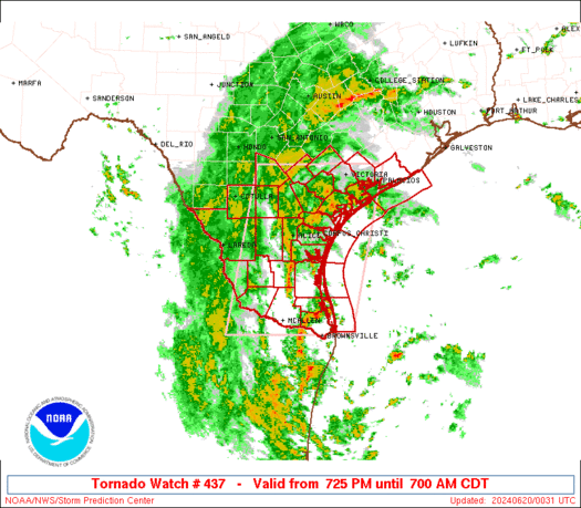
Tornado Watch Number 437
NWS Storm Prediction Center Norman OK
725 PM CDT Wed Jun 19 2024
The NWS Storm Prediction Center has issued a
* Tornado Watch for portions of
South Texas
Coastal Waters
* Effective this Wednesday night and Thursday morning from 725 PM
until 700 AM CDT.
* Primary threats include...
A few tornadoes possible
SUMMARY...A gradual strengthening and westward/inland spread of
supercell-favorable conditions is expected through the overnight
hours, north through northeast of the center of Tropical Storm
Alberto. This should increase the potential for tornadoes, at first
near parts of the lower/middle Texas Coast, then inland toward the
Rio Grande Valley by late tonight.
The tornado watch area is approximately along and 80 statute miles
east and west of a line from 20 miles south southeast of Mcallen TX
to 35 miles west northwest of Victoria TX. For a complete depiction
of the watch see the associated watch outline update (WOUS64 KWNS
WOU7).
PRECAUTIONARY/PREPAREDNESS ACTIONS...
REMEMBER...A Tornado Watch means conditions are favorable for
tornadoes and severe thunderstorms in and close to the watch
area. Persons in these areas should be on the lookout for
threatening weather conditions and listen for later statements
and possible warnings.
&&
OTHER WATCH INFORMATION...CONTINUE...WW 436...
AVIATION...Tornadoes and a few severe thunderstorms with hail
surface and aloft to 0 inches. Extreme turbulence and surface wind
gusts to 50 knots. A few cumulonimbi with maximum tops to 500. Mean
storm motion vector 10035.
...Edwards

   SEL7

   URGENT - IMMEDIATE BROADCAST REQUESTED
   Tornado Watch Number 437
   NWS Storm Prediction Center Norman OK
   725 PM CDT Wed Jun 19 2024

   The NWS Storm Prediction Center has issued a

   * Tornado Watch for portions of
     South Texas
     Coastal Waters

   * Effective this Wednesday night and Thursday morning from 725 PM
     until 700 AM CDT.

   * Primary threats include...
     A few tornadoes possible

   SUMMARY...A gradual strengthening and westward/inland spread of
   supercell-favorable conditions is expected through the overnight
   hours, north through northeast of the center of Tropical Storm
   Alberto.  This should increase the potential for tornadoes, at first
   near parts of the lower/middle Texas Coast, then inland toward the
   Rio Grande Valley by late tonight.

   The tornado watch area is approximately along and 80 statute miles
   east and west of a line from 20 miles south southeast of Mcallen TX
   to 35 miles west northwest of Victoria TX. For a complete depiction
   of the watch see the associated watch outline update (WOUS64 KWNS
   WOU7).

   PRECAUTIONARY/PREPAREDNESS ACTIONS...

   REMEMBER...A Tornado Watch means conditions are favorable for
   tornadoes and severe thunderstorms in and close to the watch
   area. Persons in these areas should be on the lookout for
   threatening weather conditions and listen for later statements
   and possible warnings.

   &&

   OTHER WATCH INFORMATION...CONTINUE...WW 436...

   AVIATION...Tornadoes and a few severe thunderstorms with hail
   surface and aloft to 0 inches. Extreme turbulence and surface wind
   gusts to 50 knots. A few cumulonimbi with maximum tops to 500. Mean
   storm motion vector 10035.

   ...Edwards
 Note:
The Aviation Watch (SAW) product is an approximation to the watch area.
The actual watch is depicted by the shaded areas.
Note:
The Aviation Watch (SAW) product is an approximation to the watch area.
The actual watch is depicted by the shaded areas.
   SAW7
   WW 437 TORNADO TX CW 200025Z - 201200Z
   AXIS..80 STATUTE MILES EAST AND WEST OF LINE..
   20SSE MFE/MCALLEN TX/ - 35WNW VCT/VICTORIA TX/
   ..AVIATION COORDS.. 70NM E/W /39W BRO - 63WNW PSX/
   WIND GUSTS..50 KNOTS.
   MAX TOPS TO 500.MEAN STORM MOTION VECTOR 10035.

   LAT...LON 25919939 29049878 29049613 25919682

   THIS IS AN APPROXIMATION TO THE WATCH AREA.  FOR A
   COMPLETE DEPICTION OF THE WATCH SEE WOUS64 KWNS
   FOR WOU7.
Watch 437 Status Report Messages:
STATUS REPORT #6 ON WW 437

VALID 200930Z - 201040Z

SEVERE WEATHER THREAT CONTINUES RIGHT OF A LINE FROM 50 NW LRD TO
25 WNW ALI TO 55 ESE CRP.

..LEITMAN..06/20/24

ATTN...WFO...CRP...EWX...BRO...HGX...

&&

STATUS REPORT FOR WT 437

SEVERE WEATHER THREAT CONTINUES FOR THE FOLLOWING AREAS

TXC047-061-131-215-247-249-261-273-355-427-479-489-505-201040-

TX
.    TEXAS COUNTIES INCLUDED ARE

BROOKS		     CAMERON		 DUVAL
HIDALGO 	     JIM HOGG		 JIM WELLS
KENEDY		     KLEBERG		 NUECES
STARR		     WEBB		 WILLACY
ZAPATA
$$


GMZ130-132-135-150-155-231-250-201040-

CW

.    ADJACENT COASTAL WATERS INCLUDED ARE

LAGUNA MADRE FROM THE PORT OF BROWNSVILLE TO THE ARROYO COLORADO

LAGUNA MADRE FROM THE ARROYO COLORADO TO 5 NM NORTH OF PORT
MANSFIELD TX

LAGUNA MADRE FROM 5 NM NORTH OF PORT MANSFIELD TO BAFFIN BAY TX

COASTAL WATERS FROM PORT MANSFIELD TX TO THE RIO GRANDE RIVER OUT
20 NM

COASTAL WATERS FROM BAFFIN BAY TO PORT MANSFIELD TX OUT 20 NM

BAFFIN BAY AND UPPER LAGUNA MADRE

COASTAL WATERS FROM BAFFIN BAY TO PORT ARANSAS OUT 20 NM

$$
THE WATCH STATUS MESSAGE IS FOR GUIDANCE PURPOSES ONLY.  PLEASE
REFER TO WATCH COUNTY NOTIFICATION STATEMENTS FOR OFFICIAL
INFORMATION ON COUNTIES...INDEPENDENT CITIES AND MARINE ZONES
CLEARED FROM SEVERE THUNDERSTORM AND TORNADO WATCHES.
$$

STATUS REPORT #5 ON WW 437

VALID 200825Z - 200940Z

SEVERE WEATHER THREAT CONTINUES RIGHT OF A LINE FROM 50 NW LRD TO
15 N ALI TO 50 ESE CRP.

..LEITMAN..06/20/24

ATTN...WFO...CRP...EWX...BRO...HGX...

&&

STATUS REPORT FOR WT 437

SEVERE WEATHER THREAT CONTINUES FOR THE FOLLOWING AREAS

TXC047-061-131-215-247-249-261-273-355-427-479-489-505-200940-

TX
.    TEXAS COUNTIES INCLUDED ARE

BROOKS		     CAMERON		 DUVAL
HIDALGO 	     JIM HOGG		 JIM WELLS
KENEDY		     KLEBERG		 NUECES
STARR		     WEBB		 WILLACY
ZAPATA
$$


GMZ130-132-135-150-155-231-250-200940-

CW

.    ADJACENT COASTAL WATERS INCLUDED ARE

LAGUNA MADRE FROM THE PORT OF BROWNSVILLE TO THE ARROYO COLORADO

LAGUNA MADRE FROM THE ARROYO COLORADO TO 5 NM NORTH OF PORT
MANSFIELD TX

LAGUNA MADRE FROM 5 NM NORTH OF PORT MANSFIELD TO BAFFIN BAY TX

COASTAL WATERS FROM PORT MANSFIELD TX TO THE RIO GRANDE RIVER OUT
20 NM

COASTAL WATERS FROM BAFFIN BAY TO PORT MANSFIELD TX OUT 20 NM

BAFFIN BAY AND UPPER LAGUNA MADRE

COASTAL WATERS FROM BAFFIN BAY TO PORT ARANSAS OUT 20 NM

$$
THE WATCH STATUS MESSAGE IS FOR GUIDANCE PURPOSES ONLY.  PLEASE
REFER TO WATCH COUNTY NOTIFICATION STATEMENTS FOR OFFICIAL
INFORMATION ON COUNTIES...INDEPENDENT CITIES AND MARINE ZONES
CLEARED FROM SEVERE THUNDERSTORM AND TORNADO WATCHES.
$$

STATUS REPORT #4 ON WW 437

VALID 200710Z - 200840Z

SEVERE WEATHER THREAT CONTINUES RIGHT OF A LINE FROM 15 S COT TO
10 SSE NIR TO 35 S PSX.

..LEITMAN..06/20/24

ATTN...WFO...CRP...EWX...BRO...HGX...

&&

STATUS REPORT FOR WT 437

SEVERE WEATHER THREAT CONTINUES FOR THE FOLLOWING AREAS

TXC007-047-061-131-215-247-249-261-273-355-409-427-479-489-505-
200840-

TX
.    TEXAS COUNTIES INCLUDED ARE

ARANSAS 	     BROOKS		 CAMERON
DUVAL		     HIDALGO		 JIM HOGG
JIM WELLS	     KENEDY		 KLEBERG
NUECES		     SAN PATRICIO	 STARR
WEBB		     WILLACY		 ZAPATA
$$


GMZ130-132-135-150-155-231-232-250-255-200840-

CW

.    ADJACENT COASTAL WATERS INCLUDED ARE

LAGUNA MADRE FROM THE PORT OF BROWNSVILLE TO THE ARROYO COLORADO

LAGUNA MADRE FROM THE ARROYO COLORADO TO 5 NM NORTH OF PORT
MANSFIELD TX

LAGUNA MADRE FROM 5 NM NORTH OF PORT MANSFIELD TO BAFFIN BAY TX

COASTAL WATERS FROM PORT MANSFIELD TX TO THE RIO GRANDE RIVER OUT
20 NM

COASTAL WATERS FROM BAFFIN BAY TO PORT MANSFIELD TX OUT 20 NM

BAFFIN BAY AND UPPER LAGUNA MADRE

CORPUS CHRISTI AND NUECES BAYS

COASTAL WATERS FROM BAFFIN BAY TO PORT ARANSAS OUT 20 NM

COASTAL WATERS FROM PORT ARANSAS TO MATAGORDA SHIP CHANNEL OUT 20
NM

$$
THE WATCH STATUS MESSAGE IS FOR GUIDANCE PURPOSES ONLY.  PLEASE
REFER TO WATCH COUNTY NOTIFICATION STATEMENTS FOR OFFICIAL
INFORMATION ON COUNTIES...INDEPENDENT CITIES AND MARINE ZONES
CLEARED FROM SEVERE THUNDERSTORM AND TORNADO WATCHES.
$$

STATUS REPORT #3 ON WW 437

VALID 200450Z - 200540Z

SEVERE WEATHER THREAT CONTINUES RIGHT OF A LINE FROM 25 ENE COT
TO 10 N VCT.

..KERR..06/20/24

ATTN...WFO...CRP...EWX...BRO...HGX...

&&

STATUS REPORT FOR WT 437

SEVERE WEATHER THREAT CONTINUES FOR THE FOLLOWING AREAS

TXC007-025-047-057-061-131-175-215-239-247-249-261-273-283-297-
311-321-355-391-409-427-469-479-489-505-200540-

TX
.    TEXAS COUNTIES INCLUDED ARE

ARANSAS 	     BEE		 BROOKS
CALHOUN 	     CAMERON		 DUVAL
GOLIAD		     HIDALGO		 JACKSON
JIM HOGG	     JIM WELLS		 KENEDY
KLEBERG 	     LA SALLE		 LIVE OAK
MCMULLEN	     MATAGORDA		 NUECES
REFUGIO 	     SAN PATRICIO	 STARR
VICTORIA	     WEBB		 WILLACY
ZAPATA
$$


GMZ130-132-135-150-155-231-232-236-237-250-255-330-350-200540-

CW

.    ADJACENT COASTAL WATERS INCLUDED ARE

LAGUNA MADRE FROM THE PORT OF BROWNSVILLE TO THE ARROYO COLORADO

LAGUNA MADRE FROM THE ARROYO COLORADO TO 5 NM NORTH OF PORT
MANSFIELD TX

LAGUNA MADRE FROM 5 NM NORTH OF PORT MANSFIELD TO BAFFIN BAY TX

COASTAL WATERS FROM PORT MANSFIELD TX TO THE RIO GRANDE RIVER OUT
20 NM

COASTAL WATERS FROM BAFFIN BAY TO PORT MANSFIELD TX OUT 20 NM

BAFFIN BAY AND UPPER LAGUNA MADRE

CORPUS CHRISTI AND NUECES BAYS

COPANO ARANSAS AND REDFISH BAYS

SAN ANTONIO MESQUITE AND ESPIRITU SANTO BAYS

COASTAL WATERS FROM BAFFIN BAY TO PORT ARANSAS OUT 20 NM

COASTAL WATERS FROM PORT ARANSAS TO MATAGORDA SHIP CHANNEL OUT 20
NM

MATAGORDA BAY

COASTAL WATERS FROM FREEPORT TO MATAGORDA SHIP CHANNEL TX OUT 20
NM

$$
THE WATCH STATUS MESSAGE IS FOR GUIDANCE PURPOSES ONLY.  PLEASE
REFER TO WATCH COUNTY NOTIFICATION STATEMENTS FOR OFFICIAL
INFORMATION ON COUNTIES...INDEPENDENT CITIES AND MARINE ZONES
CLEARED FROM SEVERE THUNDERSTORM AND TORNADO WATCHES.
$$

STATUS REPORT #2 ON WW 437

VALID 200245Z - 200340Z

THE SEVERE WEATHER THREAT CONTINUES ACROSS THE ENTIRE WATCH AREA.

..THORNTON..06/20/24

ATTN...WFO...CRP...EWX...BRO...HGX...

&&

STATUS REPORT FOR WT 437

SEVERE WEATHER THREAT CONTINUES FOR THE FOLLOWING AREAS

TXC007-013-025-047-057-061-123-131-175-215-239-247-249-255-261-
273-283-297-311-321-355-391-409-427-469-479-489-505-200340-

TX
.    TEXAS COUNTIES INCLUDED ARE

ARANSAS 	     ATASCOSA		 BEE
BROOKS		     CALHOUN		 CAMERON
DEWITT		     DUVAL		 GOLIAD
HIDALGO 	     JACKSON		 JIM HOGG
JIM WELLS	     KARNES		 KENEDY
KLEBERG 	     LA SALLE		 LIVE OAK
MCMULLEN	     MATAGORDA		 NUECES
REFUGIO 	     SAN PATRICIO	 STARR
VICTORIA	     WEBB		 WILLACY
ZAPATA
$$


GMZ130-132-135-150-155-231-232-236-237-250-255-330-350-200340-

CW

.    ADJACENT COASTAL WATERS INCLUDED ARE

LAGUNA MADRE FROM THE PORT OF BROWNSVILLE TO THE ARROYO COLORADO

LAGUNA MADRE FROM THE ARROYO COLORADO TO 5 NM NORTH OF PORT
MANSFIELD TX

LAGUNA MADRE FROM 5 NM NORTH OF PORT MANSFIELD TO BAFFIN BAY TX

COASTAL WATERS FROM PORT MANSFIELD TX TO THE RIO GRANDE RIVER OUT
20 NM

COASTAL WATERS FROM BAFFIN BAY TO PORT MANSFIELD TX OUT 20 NM

BAFFIN BAY AND UPPER LAGUNA MADRE

CORPUS CHRISTI AND NUECES BAYS

COPANO ARANSAS AND REDFISH BAYS

SAN ANTONIO MESQUITE AND ESPIRITU SANTO BAYS

COASTAL WATERS FROM BAFFIN BAY TO PORT ARANSAS OUT 20 NM

COASTAL WATERS FROM PORT ARANSAS TO MATAGORDA SHIP CHANNEL OUT 20
NM

MATAGORDA BAY

COASTAL WATERS FROM FREEPORT TO MATAGORDA SHIP CHANNEL TX OUT 20
NM

$$
THE WATCH STATUS MESSAGE IS FOR GUIDANCE PURPOSES ONLY.  PLEASE
REFER TO WATCH COUNTY NOTIFICATION STATEMENTS FOR OFFICIAL
INFORMATION ON COUNTIES...INDEPENDENT CITIES AND MARINE ZONES
CLEARED FROM SEVERE THUNDERSTORM AND TORNADO WATCHES.
$$

STATUS REPORT #1 ON WW 437

VALID 200145Z - 200240Z

THE SEVERE WEATHER THREAT CONTINUES ACROSS THE ENTIRE WATCH AREA.

..THORNTON..06/20/24

ATTN...WFO...CRP...EWX...BRO...HGX...

&&

STATUS REPORT FOR WT 437

SEVERE WEATHER THREAT CONTINUES FOR THE FOLLOWING AREAS

TXC007-013-025-047-057-061-123-131-175-215-239-247-249-255-261-
273-283-297-311-321-355-391-409-427-469-479-489-505-200240-

TX
.    TEXAS COUNTIES INCLUDED ARE

ARANSAS 	     ATASCOSA		 BEE
BROOKS		     CALHOUN		 CAMERON
DEWITT		     DUVAL		 GOLIAD
HIDALGO 	     JACKSON		 JIM HOGG
JIM WELLS	     KARNES		 KENEDY
KLEBERG 	     LA SALLE		 LIVE OAK
MCMULLEN	     MATAGORDA		 NUECES
REFUGIO 	     SAN PATRICIO	 STARR
VICTORIA	     WEBB		 WILLACY
ZAPATA
$$


GMZ130-132-135-150-155-231-232-236-237-250-255-330-350-200240-

CW

.    ADJACENT COASTAL WATERS INCLUDED ARE

LAGUNA MADRE FROM THE PORT OF BROWNSVILLE TO THE ARROYO COLORADO

LAGUNA MADRE FROM THE ARROYO COLORADO TO 5 NM NORTH OF PORT
MANSFIELD TX

LAGUNA MADRE FROM 5 NM NORTH OF PORT MANSFIELD TO BAFFIN BAY TX

COASTAL WATERS FROM PORT MANSFIELD TX TO THE RIO GRANDE RIVER OUT
20 NM

COASTAL WATERS FROM BAFFIN BAY TO PORT MANSFIELD TX OUT 20 NM

BAFFIN BAY AND UPPER LAGUNA MADRE

CORPUS CHRISTI AND NUECES BAYS

COPANO ARANSAS AND REDFISH BAYS

SAN ANTONIO MESQUITE AND ESPIRITU SANTO BAYS

COASTAL WATERS FROM BAFFIN BAY TO PORT ARANSAS OUT 20 NM

COASTAL WATERS FROM PORT ARANSAS TO MATAGORDA SHIP CHANNEL OUT 20
NM

MATAGORDA BAY

COASTAL WATERS FROM FREEPORT TO MATAGORDA SHIP CHANNEL TX OUT 20
NM

$$
THE WATCH STATUS MESSAGE IS FOR GUIDANCE PURPOSES ONLY.  PLEASE
REFER TO WATCH COUNTY NOTIFICATION STATEMENTS FOR OFFICIAL
INFORMATION ON COUNTIES...INDEPENDENT CITIES AND MARINE ZONES
CLEARED FROM SEVERE THUNDERSTORM AND TORNADO WATCHES.
$$
Note:
Click for Complete Product Text.
Tornadoes
Probability of 2 or more tornadoes
|
Mod (50%)
|
Probability of 1 or more strong (EF2-EF5) tornadoes
|
Low (20%)
|
Wind
Probability of 10 or more severe wind events
|
Low (<5%)
|
Probability of 1 or more wind events > 65 knots
|
Low (<5%)
|
Hail
Probability of 10 or more severe hail events
|
Low (<5%)
|
Probability of 1 or more hailstones > 2 inches
|
Low (<5%)
|
Combined Severe Hail/Wind
Probability of 6 or more combined severe hail/wind events
|
Low (20%)
|
For each watch, probabilities for particular events inside the watch
(listed above in each table) are determined by the issuing forecaster.
The "Low" category contains probability values ranging from less than 2%
to 20% (EF2-EF5 tornadoes), less than 5% to 20% (all other probabilities),
"Moderate" from 30% to 60%, and "High" from 70% to greater than 95%.
High values are bolded and lighter in color to provide awareness of
an increased threat for a particular event.


 @NWSSPC


