Note:
The expiration time in the watch graphic is amended if the watch is
replaced, cancelled or extended.
Note:
Note:
The expiration time in the watch graphic is amended if the watch is
replaced, cancelled or extended.
Note: Click for
Watch Status Reports.
SEL5
URGENT - IMMEDIATE BROADCAST REQUESTED
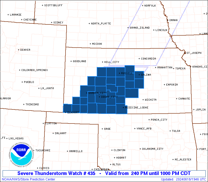
Severe Thunderstorm Watch Number 435
NWS Storm Prediction Center Norman OK
240 PM CDT Tue Jun 18 2024
The NWS Storm Prediction Center has issued a
* Severe Thunderstorm Watch for portions of
Western and Central Kansas
* Effective this Tuesday afternoon and evening from 240 PM until
1000 PM CDT.
* Primary threats include...
Scattered damaging winds likely with isolated significant gusts
to 80 mph possible
Scattered large hail likely with isolated very large hail events
to 2.5 inches in diameter possible
A tornado or two possible
SUMMARY...Thunderstorms will continue to strengthen along a cold
front this afternoon and evening while posing a threat for large to
very large hail up to around 1.5-2.5 inches in diameter and severe
wind gusts of 60-80 mph. The threat for severe winds may increase
through the evening if one or more bowing clusters develops and
spreads eastward into central Kansas. A tornado or two also appears
possible, especially if any supercells can persist across southwest
Kansas this evening.
The severe thunderstorm watch area is approximately along and 70
statute miles east and west of a line from 30 miles northeast of
Russell KS to 35 miles east of Liberal KS. For a complete depiction
of the watch see the associated watch outline update (WOUS64 KWNS
WOU5).
PRECAUTIONARY/PREPAREDNESS ACTIONS...
REMEMBER...A Severe Thunderstorm Watch means conditions are
favorable for severe thunderstorms in and close to the watch area.
Persons in these areas should be on the lookout for threatening
weather conditions and listen for later statements and possible
warnings. Severe thunderstorms can and occasionally do produce
tornadoes.
&&
OTHER WATCH INFORMATION...CONTINUE...WW 433...WW 434...
AVIATION...A few severe thunderstorms with hail surface and aloft to
2.5 inches. Extreme turbulence and surface wind gusts to 70 knots. A
few cumulonimbi with maximum tops to 600. Mean storm motion vector
25030.
...Gleason

   SEL5

   URGENT - IMMEDIATE BROADCAST REQUESTED
   Severe Thunderstorm Watch Number 435
   NWS Storm Prediction Center Norman OK
   240 PM CDT Tue Jun 18 2024

   The NWS Storm Prediction Center has issued a

   * Severe Thunderstorm Watch for portions of
     Western and Central Kansas

   * Effective this Tuesday afternoon and evening from 240 PM until
     1000 PM CDT.

   * Primary threats include...
     Scattered damaging winds likely with isolated significant gusts
       to 80 mph possible
     Scattered large hail likely with isolated very large hail events
       to 2.5 inches in diameter possible
     A tornado or two possible

   SUMMARY...Thunderstorms will continue to strengthen along a cold
   front this afternoon and evening while posing a threat for large to
   very large hail up to around 1.5-2.5 inches in diameter and severe
   wind gusts of 60-80 mph. The threat for severe winds may increase
   through the evening if one or more bowing clusters develops and
   spreads eastward into central Kansas. A tornado or two also appears
   possible, especially if any supercells can persist across southwest
   Kansas this evening.

   The severe thunderstorm watch area is approximately along and 70
   statute miles east and west of a line from 30 miles northeast of
   Russell KS to 35 miles east of Liberal KS. For a complete depiction
   of the watch see the associated watch outline update (WOUS64 KWNS
   WOU5).

   PRECAUTIONARY/PREPAREDNESS ACTIONS...

   REMEMBER...A Severe Thunderstorm Watch means conditions are
   favorable for severe thunderstorms in and close to the watch area.
   Persons in these areas should be on the lookout for threatening
   weather conditions and listen for later statements and possible
   warnings. Severe thunderstorms can and occasionally do produce
   tornadoes.

   &&

   OTHER WATCH INFORMATION...CONTINUE...WW 433...WW 434...

   AVIATION...A few severe thunderstorms with hail surface and aloft to
   2.5 inches. Extreme turbulence and surface wind gusts to 70 knots. A
   few cumulonimbi with maximum tops to 600. Mean storm motion vector
   25030.

   ...Gleason
 Note:
The Aviation Watch (SAW) product is an approximation to the watch area.
The actual watch is depicted by the shaded areas.
Note:
The Aviation Watch (SAW) product is an approximation to the watch area.
The actual watch is depicted by the shaded areas.
   SAW5
   WW 435 SEVERE TSTM KS 181940Z - 190300Z
   AXIS..70 STATUTE MILES EAST AND WEST OF LINE..
   30NE RSL/RUSSELL KS/ - 35E LBL/LIBERAL KS/
   ..AVIATION COORDS.. 60NM E/W /40WNW SLN - 30E LBL/
   HAIL SURFACE AND ALOFT..2.5 INCHES. WIND GUSTS..70 KNOTS.
   MAX TOPS TO 600. MEAN STORM MOTION VECTOR 25030.

   LAT...LON 39169712 37039907 37030160 39169973

   THIS IS AN APPROXIMATION TO THE WATCH AREA.  FOR A
   COMPLETE DEPICTION OF THE WATCH SEE WOUS64 KWNS
   FOR WOU5.
Watch 435 Status Report Messages:
STATUS REPORT #5 ON WW 435
VALID 190255Z - 190300Z
SEVERE WEATHER THREAT CONTINUES RIGHT OF A LINE FROM 10 SSW EHA
TO 30 NW MHK.
WW 435 WILL BE ALLOWED TO EXPIRE AT 190300Z.
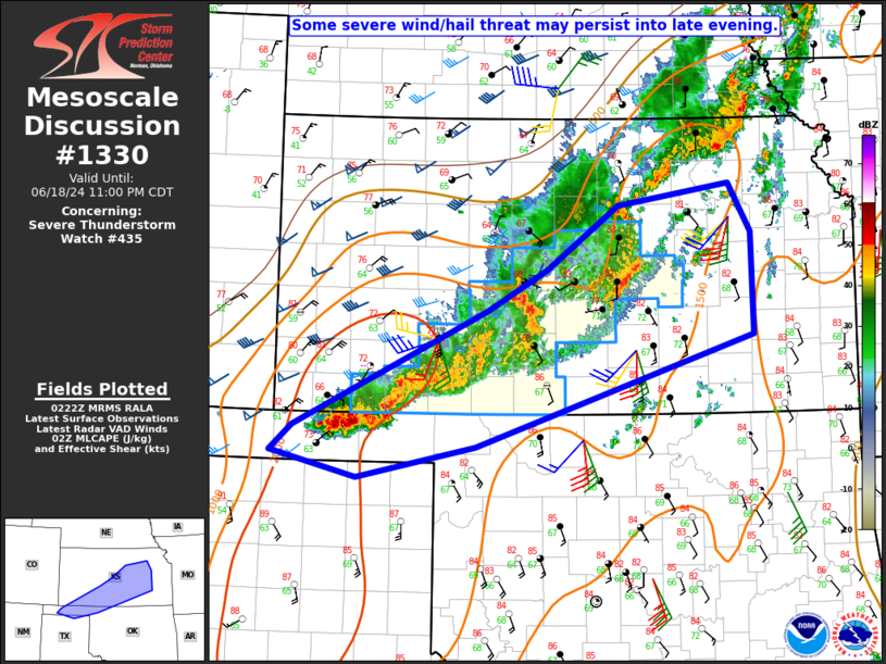
FOR ADDITIONAL INFORMATION SEE MESOSCALE DISCUSSION 1330
..DEAN..06/19/24
ATTN...WFO...DDC...ICT...
&&
STATUS REPORT FOR WS 435
SEVERE WEATHER THREAT CONTINUES FOR THE FOLLOWING AREAS
KSC007-009-025-033-047-057-097-113-115-119-145-151-155-159-169-
175-185-190300-
KS
. KANSAS COUNTIES INCLUDED ARE
BARBER BARTON CLARK
COMANCHE EDWARDS FORD
KIOWA MCPHERSON MARION
MEADE PAWNEE PRATT
RENO RICE SALINE
SEWARD STAFFORD
$$
THE WATCH STATUS MESSAGE IS FOR GUIDANCE PURPOSES ONLY. PLEASE
REFER TO WATCH COUNTY NOTIFICATION STATEMENTS FOR OFFICIAL
INFORMATION ON COUNTIES...INDEPENDENT CITIES AND MARINE ZONES
CLEARED FROM SEVERE THUNDERSTORM AND TORNADO WATCHES.
$$
STATUS REPORT #4 ON WW 435
VALID 190205Z - 190340Z
SEVERE WEATHER THREAT CONTINUES RIGHT OF A LINE FROM 5 SW EHA TO
30 WNW SLN TO 20 SE CNK.
FOR ADDITIONAL INFORMATION SEE MESOSCALE DISCUSSION
..DEAN..06/19/24
ATTN...WFO...DDC...ICT...
&&
STATUS REPORT FOR WS 435
SEVERE WEATHER THREAT CONTINUES FOR THE FOLLOWING AREAS
KSC007-009-025-033-047-057-097-113-115-119-145-151-155-159-169-
175-185-190340-
KS
. KANSAS COUNTIES INCLUDED ARE
BARBER BARTON CLARK
COMANCHE EDWARDS FORD
KIOWA MCPHERSON MARION
MEADE PAWNEE PRATT
RENO RICE SALINE
SEWARD STAFFORD
$$
THE WATCH STATUS MESSAGE IS FOR GUIDANCE PURPOSES ONLY. PLEASE
REFER TO WATCH COUNTY NOTIFICATION STATEMENTS FOR OFFICIAL
INFORMATION ON COUNTIES...INDEPENDENT CITIES AND MARINE ZONES
CLEARED FROM SEVERE THUNDERSTORM AND TORNADO WATCHES.
$$
STATUS REPORT #3 ON WW 435
VALID 182345Z - 190040Z
SEVERE WEATHER THREAT CONTINUES RIGHT OF A LINE FROM 5 WSW EHA TO
10 ENE GCK TO 25 SW HLC.
FOR ADDITIONAL INFORMATION SEE MESOSCALE DISCUSSION 1328
..DEAN..06/18/24
ATTN...WFO...DDC...ICT...
&&
STATUS REPORT FOR WS 435
SEVERE WEATHER THREAT CONTINUES FOR THE FOLLOWING AREAS
KSC007-009-025-033-047-051-053-057-069-081-083-097-105-113-119-
135-145-151-155-159-165-167-169-175-185-195-190040-
KS
. KANSAS COUNTIES INCLUDED ARE
BARBER BARTON CLARK
COMANCHE EDWARDS ELLIS
ELLSWORTH FORD GRAY
HASKELL HODGEMAN KIOWA
LINCOLN MCPHERSON MEADE
NESS PAWNEE PRATT
RENO RICE RUSH
RUSSELL SALINE SEWARD
STAFFORD TREGO
$$
THE WATCH STATUS MESSAGE IS FOR GUIDANCE PURPOSES ONLY. PLEASE
REFER TO WATCH COUNTY NOTIFICATION STATEMENTS FOR OFFICIAL
INFORMATION ON COUNTIES...INDEPENDENT CITIES AND MARINE ZONES
CLEARED FROM SEVERE THUNDERSTORM AND TORNADO WATCHES.
$$
STATUS REPORT #2 ON WW 435
VALID 182150Z - 182240Z
THE SEVERE WEATHER THREAT CONTINUES ACROSS THE ENTIRE WATCH AREA.
FOR ADDITIONAL INFORMATION SEE MESOSCALE DISCUSSION 1325
..DEAN..06/18/24
ATTN...WFO...DDC...ICT...
&&
STATUS REPORT FOR WS 435
SEVERE WEATHER THREAT CONTINUES FOR THE FOLLOWING AREAS
KSC007-009-025-033-047-051-053-055-057-067-069-081-083-097-101-
105-113-119-129-135-145-151-155-159-165-167-169-175-185-189-195-
182240-
KS
. KANSAS COUNTIES INCLUDED ARE
BARBER BARTON CLARK
COMANCHE EDWARDS ELLIS
ELLSWORTH FINNEY FORD
GRANT GRAY HASKELL
HODGEMAN KIOWA LANE
LINCOLN MCPHERSON MEADE
MORTON NESS PAWNEE
PRATT RENO RICE
RUSH RUSSELL SALINE
SEWARD STAFFORD STEVENS
TREGO
$$
THE WATCH STATUS MESSAGE IS FOR GUIDANCE PURPOSES ONLY. PLEASE
REFER TO WATCH COUNTY NOTIFICATION STATEMENTS FOR OFFICIAL
INFORMATION ON COUNTIES...INDEPENDENT CITIES AND MARINE ZONES
CLEARED FROM SEVERE THUNDERSTORM AND TORNADO WATCHES.
$$
STATUS REPORT #1 ON WW 435
VALID 182040Z - 182140Z
THE SEVERE WEATHER THREAT CONTINUES ACROSS THE ENTIRE WATCH AREA.
..LYONS..06/18/24
ATTN...WFO...DDC...ICT...
&&
STATUS REPORT FOR WS 435
SEVERE WEATHER THREAT CONTINUES FOR THE FOLLOWING AREAS
KSC007-009-025-033-047-051-053-055-057-067-069-081-083-097-101-
105-113-119-129-135-145-151-155-159-165-167-169-175-185-189-195-
182140-
KS
. KANSAS COUNTIES INCLUDED ARE
BARBER BARTON CLARK
COMANCHE EDWARDS ELLIS
ELLSWORTH FINNEY FORD
GRANT GRAY HASKELL
HODGEMAN KIOWA LANE
LINCOLN MCPHERSON MEADE
MORTON NESS PAWNEE
PRATT RENO RICE
RUSH RUSSELL SALINE
SEWARD STAFFORD STEVENS
TREGO
$$
THE WATCH STATUS MESSAGE IS FOR GUIDANCE PURPOSES ONLY. PLEASE
REFER TO WATCH COUNTY NOTIFICATION STATEMENTS FOR OFFICIAL
INFORMATION ON COUNTIES...INDEPENDENT CITIES AND MARINE ZONES
CLEARED FROM SEVERE THUNDERSTORM AND TORNADO WATCHES.
$$
Note:
Click for Complete Product Text.
Tornadoes
Probability of 2 or more tornadoes
|
Low (20%)
|
Probability of 1 or more strong (EF2-EF5) tornadoes
|
Low (10%)
|
Wind
Probability of 10 or more severe wind events
|
High (70%)
|
Probability of 1 or more wind events > 65 knots
|
Mod (40%)
|
Hail
Probability of 10 or more severe hail events
|
Mod (60%)
|
Probability of 1 or more hailstones > 2 inches
|
Mod (50%)
|
Combined Severe Hail/Wind
Probability of 6 or more combined severe hail/wind events
|
High (90%)
|
For each watch, probabilities for particular events inside the watch
(listed above in each table) are determined by the issuing forecaster.
The "Low" category contains probability values ranging from less than 2%
to 20% (EF2-EF5 tornadoes), less than 5% to 20% (all other probabilities),
"Moderate" from 30% to 60%, and "High" from 70% to greater than 95%.
High values are bolded and lighter in color to provide awareness of
an increased threat for a particular event.


 @NWSSPC