Note:
The expiration time in the watch graphic is amended if the watch is
replaced, cancelled or extended.
Note:
Note:
The expiration time in the watch graphic is amended if the watch is
replaced, cancelled or extended.
Note: Click for
Watch Status Reports.
   SEL0

   URGENT - IMMEDIATE BROADCAST REQUESTED
   Severe Thunderstorm Watch Number 370
   NWS Storm Prediction Center Norman OK
   735 PM CDT Sat Jun 1 2024

   The NWS Storm Prediction Center has issued a

   * Severe Thunderstorm Watch for portions of
     Northwest Oklahoma
     Northern Texas Panhandle

   * Effective this Saturday night and Sunday morning from 735 PM
     until 100 AM CDT.

   * Primary threats include...
     Scattered large hail likely with isolated very large hail events
       to 2 inches in diameter possible
     Scattered damaging wind gusts to 70 mph likely

   SUMMARY...Clusters of thunderstorms over southwest Kansas will move
   southeastward into the watch area this evening, with locally
   damaging winds and hail possible in the stronger cells.

   The severe thunderstorm watch area is approximately along and 45
   statute miles north and south of a line from 35 miles southwest of
   Guymon OK to 15 miles east southeast of Alva OK. For a complete
   depiction of the watch see the associated watch outline update
   (WOUS64 KWNS WOU0).

   PRECAUTIONARY/PREPAREDNESS ACTIONS...

   REMEMBER...A Severe Thunderstorm Watch means conditions are
   favorable for severe thunderstorms in and close to the watch area.
   Persons in these areas should be on the lookout for threatening
   weather conditions and listen for later statements and possible
   warnings. Severe thunderstorms can and occasionally do produce
   tornadoes.

   &&

   OTHER WATCH INFORMATION...CONTINUE...WW 366...WW 367...WW
   368...WW 369...

   AVIATION...A few severe thunderstorms with hail surface and aloft to
   2 inches. Extreme turbulence and surface wind gusts to 60 knots. A
   few cumulonimbi with maximum tops to 500. Mean storm motion vector
   29030.

   ...Hart
 Note:
The Aviation Watch (SAW) product is an approximation to the watch area.
The actual watch is depicted by the shaded areas.
Note:
The Aviation Watch (SAW) product is an approximation to the watch area.
The actual watch is depicted by the shaded areas.
   SAW0
   WW 370 SEVERE TSTM OK TX 020035Z - 020600Z
   AXIS..45 STATUTE MILES NORTH AND SOUTH OF LINE..
   35SW GUY/GUYMON OK/ - 15ESE AVK/ALVA OK/
   ..AVIATION COORDS.. 40NM N/S /64NNW AMA - 31NW END/
   HAIL SURFACE AND ALOFT..2 INCHES. WIND GUSTS..60 KNOTS.
   MAX TOPS TO 500. MEAN STORM MOTION VECTOR 29030.

   LAT...LON 36970194 37349842 36049842 35660194

   THIS IS AN APPROXIMATION TO THE WATCH AREA.  FOR A
   COMPLETE DEPICTION OF THE WATCH SEE WOUS64 KWNS
   FOR WOU0.
Watch 370 Status Report Messages:
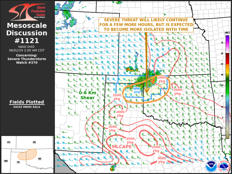
STATUS REPORT #3 ON WW 370

VALID 020535Z - 020600Z

SEVERE WEATHER THREAT CONTINUES RIGHT OF A LINE FROM 5 NE BGD TO
25 SE GUY TO 20 SSE P28.

WW 370 WILL BE ALLOWED TO EXPIRE AT 020600Z.

FOR ADDITIONAL INFORMATION SEE MESOSCALE DISCUSSION 1121.

..GRAMS..06/02/24

ATTN...WFO...OUN...AMA...

&&

STATUS REPORT FOR WS 370

SEVERE WEATHER THREAT CONTINUES FOR THE FOLLOWING AREAS

OKC003-043-045-093-129-151-153-020600-

OK
.    OKLAHOMA COUNTIES INCLUDED ARE

ALFALFA 	     DEWEY		 ELLIS
MAJOR		     ROGER MILLS	 WOODS
WOODWARD
$$


TXC211-295-357-393-020600-

TX
.    TEXAS COUNTIES INCLUDED ARE

HEMPHILL	     LIPSCOMB		 OCHILTREE
ROBERTS
$$


THE WATCH STATUS MESSAGE IS FOR GUIDANCE PURPOSES ONLY.  PLEASE
REFER TO WATCH COUNTY NOTIFICATION STATEMENTS FOR OFFICIAL
INFORMATION ON COUNTIES...INDEPENDENT CITIES AND MARINE ZONES
CLEARED FROM SEVERE THUNDERSTORM AND TORNADO WATCHES.
$$

STATUS REPORT #2 ON WW 370

VALID 020430Z - 020540Z

SEVERE WEATHER THREAT CONTINUES RIGHT OF A LINE FROM 40 SSW EHA
TO 50 ESE LBL TO 35 W P28.

..BROYLES..06/02/24

ATTN...WFO...OUN...AMA...

&&

STATUS REPORT FOR WS 370

SEVERE WEATHER THREAT CONTINUES FOR THE FOLLOWING AREAS

OKC003-043-045-059-093-129-151-153-020540-

OK
.    OKLAHOMA COUNTIES INCLUDED ARE

ALFALFA 	     DEWEY		 ELLIS
HARPER		     MAJOR		 ROGER MILLS
WOODS		     WOODWARD
$$


TXC195-211-233-295-341-357-393-421-020540-

TX
.    TEXAS COUNTIES INCLUDED ARE

HANSFORD	     HEMPHILL		 HUTCHINSON
LIPSCOMB	     MOORE		 OCHILTREE
ROBERTS 	     SHERMAN
$$


THE WATCH STATUS MESSAGE IS FOR GUIDANCE PURPOSES ONLY.  PLEASE
REFER TO WATCH COUNTY NOTIFICATION STATEMENTS FOR OFFICIAL
INFORMATION ON COUNTIES...INDEPENDENT CITIES AND MARINE ZONES
CLEARED FROM SEVERE THUNDERSTORM AND TORNADO WATCHES.
$$

STATUS REPORT #1 ON WW 370

VALID 020340Z - 020440Z

SEVERE WEATHER THREAT CONTINUES RIGHT OF A LINE FROM 30 SSW EHA
TO 10 ENE GUY TO 20 ENE LBL.

..BROYLES..06/02/24

ATTN...WFO...OUN...AMA...

&&

STATUS REPORT FOR WS 370

SEVERE WEATHER THREAT CONTINUES FOR THE FOLLOWING AREAS

OKC003-007-043-045-059-093-129-151-153-020440-

OK
.    OKLAHOMA COUNTIES INCLUDED ARE

ALFALFA 	     BEAVER		 DEWEY
ELLIS		     HARPER		 MAJOR
ROGER MILLS	     WOODS		 WOODWARD
$$


TXC195-211-233-295-341-357-393-421-020440-

TX
.    TEXAS COUNTIES INCLUDED ARE

HANSFORD	     HEMPHILL		 HUTCHINSON
LIPSCOMB	     MOORE		 OCHILTREE
ROBERTS 	     SHERMAN
$$


THE WATCH STATUS MESSAGE IS FOR GUIDANCE PURPOSES ONLY.  PLEASE
REFER TO WATCH COUNTY NOTIFICATION STATEMENTS FOR OFFICIAL
INFORMATION ON COUNTIES...INDEPENDENT CITIES AND MARINE ZONES
CLEARED FROM SEVERE THUNDERSTORM AND TORNADO WATCHES.
$$
Note:
Click for Complete Product Text.
Tornadoes
Probability of 2 or more tornadoes
|
Low (10%)
|
Probability of 1 or more strong (EF2-EF5) tornadoes
|
Low (<2%)
|
Wind
Probability of 10 or more severe wind events
|
Mod (60%)
|
Probability of 1 or more wind events > 65 knots
|
Low (10%)
|
Hail
Probability of 10 or more severe hail events
|
Mod (60%)
|
Probability of 1 or more hailstones > 2 inches
|
Mod (30%)
|
Combined Severe Hail/Wind
Probability of 6 or more combined severe hail/wind events
|
High (>95%)
|
For each watch, probabilities for particular events inside the watch
(listed above in each table) are determined by the issuing forecaster.
The "Low" category contains probability values ranging from less than 2%
to 20% (EF2-EF5 tornadoes), less than 5% to 20% (all other probabilities),
"Moderate" from 30% to 60%, and "High" from 70% to greater than 95%.
High values are bolded and lighter in color to provide awareness of
an increased threat for a particular event.


 @NWSSPC