 Note:
The expiration time in the watch graphic is amended if the watch is
replaced, cancelled or extended.
Note:
Note:
The expiration time in the watch graphic is amended if the watch is
replaced, cancelled or extended.
Note: Click for
Watch Status Reports.
SEL6
URGENT - IMMEDIATE BROADCAST REQUESTED
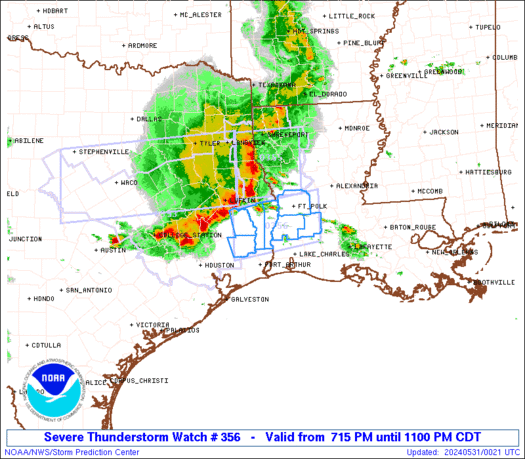
Severe Thunderstorm Watch Number 356
NWS Storm Prediction Center Norman OK
715 PM CDT Thu May 30 2024
The NWS Storm Prediction Center has issued a
* Severe Thunderstorm Watch for portions of
Southwest Louisiana
Southeast Texas
* Effective this Thursday evening from 715 PM until 1100 PM CDT.
* Primary threats include...
Scattered damaging wind gusts to 70 mph possible
Isolated large hail events to 1.5 inches in diameter possible
SUMMARY...Clusters of thunderstorms over southeast Texas will track
eastward into the watch area this evening. The strongest storms
will pose a risk of locally damaging wind gusts and hail.
The severe thunderstorm watch area is approximately along and 35
statute miles north and south of a line from 90 miles west southwest
of Fort Polk LA to 35 miles east southeast of Fort Polk LA. For a
complete depiction of the watch see the associated watch outline
update (WOUS64 KWNS WOU6).
PRECAUTIONARY/PREPAREDNESS ACTIONS...
REMEMBER...A Severe Thunderstorm Watch means conditions are
favorable for severe thunderstorms in and close to the watch area.
Persons in these areas should be on the lookout for threatening
weather conditions and listen for later statements and possible
warnings. Severe thunderstorms can and occasionally do produce
tornadoes.
&&
OTHER WATCH INFORMATION...CONTINUE...WW 352...WW 353...WW
354...WW 355...
AVIATION...A few severe thunderstorms with hail surface and aloft to
1.5 inches. Extreme turbulence and surface wind gusts to 60 knots. A
few cumulonimbi with maximum tops to 500. Mean storm motion vector
28025.
...Hart
 Note:
The Aviation Watch (SAW) product is an approximation to the watch area.
The actual watch is depicted by the shaded areas.
Note:
The Aviation Watch (SAW) product is an approximation to the watch area.
The actual watch is depicted by the shaded areas.
   SAW6
   WW 356 SEVERE TSTM LA TX 310015Z - 310400Z
   AXIS..35 STATUTE MILES NORTH AND SOUTH OF LINE..
   90WSW POE/FORT POLK LA/ - 35ESE POE/FORT POLK LA/
   ..AVIATION COORDS.. 30NM N/S /38SSE LFK - 25SSW AEX/
   HAIL SURFACE AND ALOFT..1.5 INCHES. WIND GUSTS..60 KNOTS.
   MAX TOPS TO 500. MEAN STORM MOTION VECTOR 28025.

   LAT...LON 31059458 31369263 30359263 30049458

   THIS IS AN APPROXIMATION TO THE WATCH AREA.  FOR A
   COMPLETE DEPICTION OF THE WATCH SEE WOUS64 KWNS
   FOR WOU6.
Watch 356 Status Report Messages:
STATUS REPORT #3 ON WW 356

VALID 310335Z - 310440Z

SEVERE WEATHER THREAT CONTINUES RIGHT OF A LINE FROM 25 WNW LCH
TO 30 NNE LCH TO 25 WSW ESF TO 30 SW ELD.

..LYONS..05/31/24

ATTN...WFO...LCH...

&&

STATUS REPORT FOR WS 356

SEVERE WEATHER THREAT CONTINUES FOR THE FOLLOWING AREAS

LAC003-009-039-079-097-310440-

LA
.    LOUISIANA PARISHES INCLUDED ARE

ALLEN		     AVOYELLES		 EVANGELINE
RAPIDES 	     ST. LANDRY
$$


THE WATCH STATUS MESSAGE IS FOR GUIDANCE PURPOSES ONLY.  PLEASE
REFER TO WATCH COUNTY NOTIFICATION STATEMENTS FOR OFFICIAL
INFORMATION ON COUNTIES...INDEPENDENT CITIES AND MARINE ZONES
CLEARED FROM SEVERE THUNDERSTORM AND TORNADO WATCHES.
$$

STATUS REPORT #2 ON WW 356

VALID 310150Z - 310240Z

SEVERE WEATHER THREAT CONTINUES RIGHT OF A LINE FROM 50 S LFK TO
50 SE LFK TO 40 W POE TO 40 NW POE.

..LYONS..05/31/24

ATTN...WFO...LCH...

&&

STATUS REPORT FOR WS 356

SEVERE WEATHER THREAT CONTINUES FOR THE FOLLOWING AREAS

LAC003-011-115-310240-

LA
.    LOUISIANA PARISHES INCLUDED ARE

ALLEN		     BEAUREGARD 	 VERNON
$$


TXC199-351-310240-

TX
.    TEXAS COUNTIES INCLUDED ARE

HARDIN		     NEWTON
$$


THE WATCH STATUS MESSAGE IS FOR GUIDANCE PURPOSES ONLY.  PLEASE
REFER TO WATCH COUNTY NOTIFICATION STATEMENTS FOR OFFICIAL
INFORMATION ON COUNTIES...INDEPENDENT CITIES AND MARINE ZONES
CLEARED FROM SEVERE THUNDERSTORM AND TORNADO WATCHES.
$$

STATUS REPORT #1 ON WW 356

VALID 310035Z - 310140Z

THE SEVERE WEATHER THREAT CONTINUES ACROSS THE ENTIRE WATCH AREA.

..DEAN..05/31/24

ATTN...WFO...LCH...

&&

STATUS REPORT FOR WS 356

SEVERE WEATHER THREAT CONTINUES FOR THE FOLLOWING AREAS

LAC003-011-115-310140-

LA
.    LOUISIANA PARISHES INCLUDED ARE

ALLEN		     BEAUREGARD 	 VERNON
$$


TXC199-241-351-457-310140-

TX
.    TEXAS COUNTIES INCLUDED ARE

HARDIN		     JASPER		 NEWTON
TYLER
$$


THE WATCH STATUS MESSAGE IS FOR GUIDANCE PURPOSES ONLY.  PLEASE
REFER TO WATCH COUNTY NOTIFICATION STATEMENTS FOR OFFICIAL
INFORMATION ON COUNTIES...INDEPENDENT CITIES AND MARINE ZONES
CLEARED FROM SEVERE THUNDERSTORM AND TORNADO WATCHES.
$$
Note:
Click for Complete Product Text.
Tornadoes
Probability of 2 or more tornadoes
|
Low (<5%)
|
Probability of 1 or more strong (EF2-EF5) tornadoes
|
Low (<2%)
|
Wind
Probability of 10 or more severe wind events
|
Mod (40%)
|
Probability of 1 or more wind events > 65 knots
|
Low (20%)
|
Hail
Probability of 10 or more severe hail events
|
Low (20%)
|
Probability of 1 or more hailstones > 2 inches
|
Low (10%)
|
Combined Severe Hail/Wind
Probability of 6 or more combined severe hail/wind events
|
Mod (60%)
|
For each watch, probabilities for particular events inside the watch
(listed above in each table) are determined by the issuing forecaster.
The "Low" category contains probability values ranging from less than 2%
to 20% (EF2-EF5 tornadoes), less than 5% to 20% (all other probabilities),
"Moderate" from 30% to 60%, and "High" from 70% to greater than 95%.
High values are bolded and lighter in color to provide awareness of
an increased threat for a particular event.


 @NWSSPC


