Note:
The expiration time in the watch graphic is amended if the watch is
replaced, cancelled or extended.
Note:
Note:
The expiration time in the watch graphic is amended if the watch is
replaced, cancelled or extended.
Note: Click for
Watch Status Reports.
SEL7
URGENT - IMMEDIATE BROADCAST REQUESTED
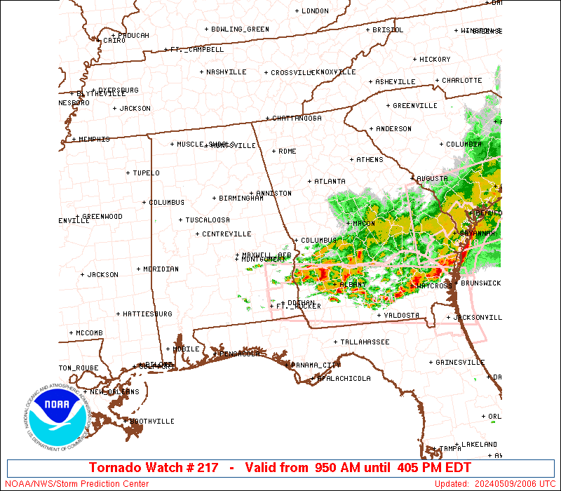
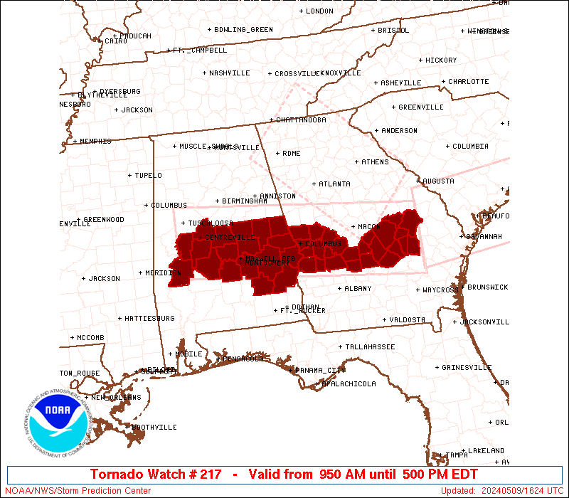
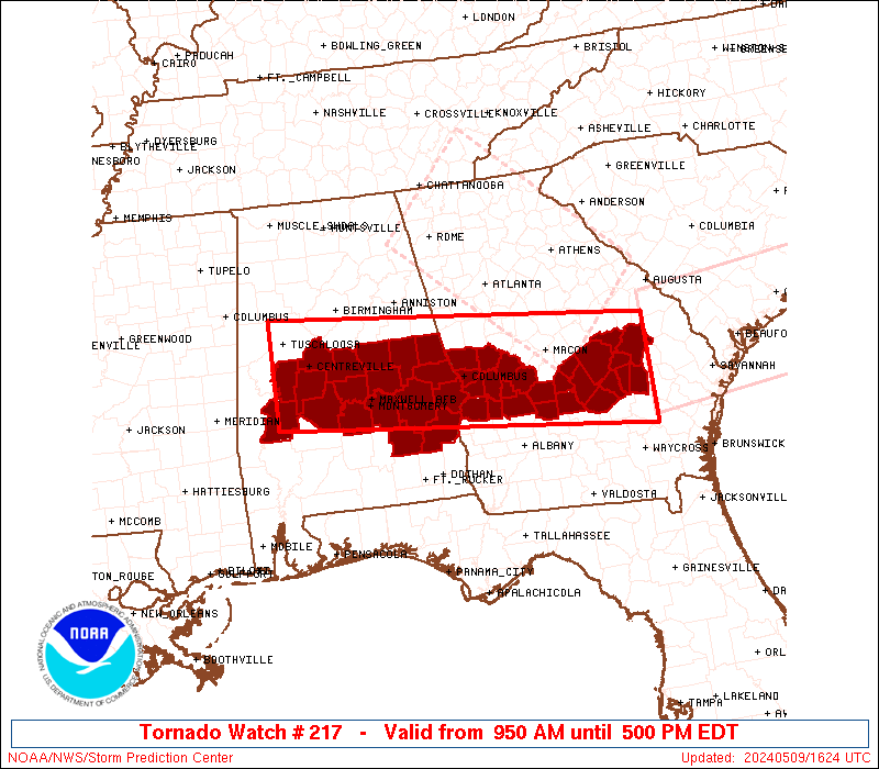
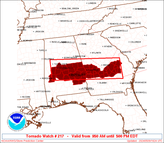
Tornado Watch Number 217
NWS Storm Prediction Center Norman OK
950 AM EDT Thu May 9 2024
The NWS Storm Prediction Center has issued a
* Tornado Watch for portions of
Central and Eastern Alabama
Central Georgia
* Effective this Thursday morning and afternoon from 950 AM until
500 PM EDT.
* Primary threats include...
A couple tornadoes possible
Widespread damaging wind gusts to 70 mph likely
Scattered large hail likely with isolated very large hail events
to 2 inches in diameter possible
SUMMARY...Bands of strong to severe storms will likely continue to
push east-southeast across the Watch area through the early to mid
afternoon. A few supercells are possible ahead of the main
thunderstorm bands and will also pose a severe risk, including the
threat for tornadoes and large hail. Damaging gusts will be the
primary hazard with the thunderstorm bands, but a tornado may also
accompany any embedded stronger circulations within the line.
The tornado watch area is approximately along and 50 statute miles
north and south of a line from 30 miles south southwest of
Tuscaloosa AL to 15 miles east northeast of Vidalia GA. For a
complete depiction of the watch see the associated watch outline
update (WOUS64 KWNS WOU7).
PRECAUTIONARY/PREPAREDNESS ACTIONS...
REMEMBER...A Tornado Watch means conditions are favorable for
tornadoes and severe thunderstorms in and close to the watch
area. Persons in these areas should be on the lookout for
threatening weather conditions and listen for later statements
and possible warnings.
&&
OTHER WATCH INFORMATION...CONTINUE...WW 215...WW 216...
AVIATION...Tornadoes and a few severe thunderstorms with hail
surface and aloft to 2 inches. Extreme turbulence and surface wind
gusts to 60 knots. A few cumulonimbi with maximum tops to 500. Mean
storm motion vector 26035.
...Smith

   SEL7

   URGENT - IMMEDIATE BROADCAST REQUESTED
   Tornado Watch Number 217
   NWS Storm Prediction Center Norman OK
   950 AM EDT Thu May 9 2024

   The NWS Storm Prediction Center has issued a

   * Tornado Watch for portions of
     Central and Eastern Alabama
     Central Georgia

   * Effective this Thursday morning and afternoon from 950 AM until
     500 PM EDT.

   * Primary threats include...
     A couple tornadoes possible
     Widespread damaging wind gusts to 70 mph likely
     Scattered large hail likely with isolated very large hail events
       to 2 inches in diameter possible

   SUMMARY...Bands of strong to severe storms will likely continue to
   push east-southeast across the Watch area through the early to mid
   afternoon.  A few supercells are possible ahead of the main
   thunderstorm bands and will also pose a severe risk, including the
   threat for tornadoes and large hail.  Damaging gusts will be the
   primary hazard with the thunderstorm bands, but a tornado may also
   accompany any embedded stronger circulations within the line.

   The tornado watch area is approximately along and 50 statute miles
   north and south of a line from 30 miles south southwest of
   Tuscaloosa AL to 15 miles east northeast of Vidalia GA. For a
   complete depiction of the watch see the associated watch outline
   update (WOUS64 KWNS WOU7).

   PRECAUTIONARY/PREPAREDNESS ACTIONS...

   REMEMBER...A Tornado Watch means conditions are favorable for
   tornadoes and severe thunderstorms in and close to the watch
   area. Persons in these areas should be on the lookout for
   threatening weather conditions and listen for later statements
   and possible warnings.

   &&

   OTHER WATCH INFORMATION...CONTINUE...WW 215...WW 216...

   AVIATION...Tornadoes and a few severe thunderstorms with hail
   surface and aloft to 2 inches. Extreme turbulence and surface wind
   gusts to 60 knots. A few cumulonimbi with maximum tops to 500. Mean
   storm motion vector 26035.

   ...Smith
 Note:
The Aviation Watch (SAW) product is an approximation to the watch area.
The actual watch is depicted by the shaded areas.
Note:
The Aviation Watch (SAW) product is an approximation to the watch area.
The actual watch is depicted by the shaded areas.
   SAW7
   WW 217 TORNADO AL GA 091350Z - 092100Z
   AXIS..50 STATUTE MILES NORTH AND SOUTH OF LINE..
   30SSW TCL/TUSCALOOSA AL/ - 15ENE VDI/VIDALIA GA/
   ..AVIATION COORDS.. 45NM N/S /53SE IGB - 48NNE AMG/
   HAIL SURFACE AND ALOFT..2 INCHES. WIND GUSTS..60 KNOTS.
   MAX TOPS TO 500. MEAN STORM MOTION VECTOR 26035.

   LAT...LON 33548782 33008213 31558213 32098782

   THIS IS AN APPROXIMATION TO THE WATCH AREA.  FOR A
   COMPLETE DEPICTION OF THE WATCH SEE WOUS64 KWNS
   FOR WOU7.
Watch 217 Status Report Messages:
STATUS REPORT #5 ON WW 217

VALID 091925Z - 092040Z

SEVERE WEATHER THREAT CONTINUES RIGHT OF A LINE FROM 30 SSW SEM
TO 20 NNE SEM TO 10 ESE LGC.

..BENTLEY..05/09/24

ATTN...WFO...BMX...FFC...

&&

STATUS REPORT FOR WT 217

SEVERE WEATHER THREAT CONTINUES FOR THE FOLLOWING AREAS

ALC001-005-011-051-081-085-087-101-109-113-092040-

AL
.    ALABAMA COUNTIES INCLUDED ARE

AUTAUGA 	     BARBOUR		 BULLOCK
ELMORE		     LEE		 LOWNDES
MACON		     MONTGOMERY 	 PIKE
RUSSELL
$$


GAC023-053-081-091-093-107-145-175-193-197-209-215-235-249-259-
261-263-269-271-279-283-307-309-315-092040-

GA
.    GEORGIA COUNTIES INCLUDED ARE

BLECKLEY	     CHATTAHOOCHEE	 CRISP
DODGE		     DOOLY		 EMANUEL
HARRIS		     LAURENS		 MACON
MARION		     MONTGOMERY 	 MUSCOGEE
PULASKI 	     SCHLEY		 STEWART
SUMTER		     TALBOT		 TAYLOR
TELFAIR 	     TOOMBS		 TREUTLEN
WEBSTER 	     WHEELER		 WILCOX
$$


THE WATCH STATUS MESSAGE IS FOR GUIDANCE PURPOSES ONLY.  PLEASE
REFER TO WATCH COUNTY NOTIFICATION STATEMENTS FOR OFFICIAL
INFORMATION ON COUNTIES...INDEPENDENT CITIES AND MARINE ZONES
CLEARED FROM SEVERE THUNDERSTORM AND TORNADO WATCHES.
$$

STATUS REPORT #4 ON WW 217

VALID 091800Z - 091940Z

SEVERE WEATHER THREAT CONTINUES RIGHT OF A LINE FROM 15 SE ANB TO
5 SE ANB TO 10 SW LGC TO 40 WSW MCN TO 40 NW VDI TO 30 SSE AGS.

..BENTLEY..05/09/24

ATTN...WFO...BMX...FFC...

&&

STATUS REPORT FOR WT 217

SEVERE WEATHER THREAT CONTINUES FOR THE FOLLOWING AREAS

ALC001-005-011-017-037-051-081-085-087-101-109-113-123-091940-

AL
.    ALABAMA COUNTIES INCLUDED ARE

AUTAUGA 	     BARBOUR		 BULLOCK
CHAMBERS	     COOSA		 ELMORE
LEE		     LOWNDES		 MACON
MONTGOMERY	     PIKE		 RUSSELL
TALLAPOOSA
$$


GAC023-053-081-091-093-107-145-175-193-197-209-215-235-249-259-
261-263-269-271-279-283-307-309-315-091940-

GA
.    GEORGIA COUNTIES INCLUDED ARE

BLECKLEY	     CHATTAHOOCHEE	 CRISP
DODGE		     DOOLY		 EMANUEL
HARRIS		     LAURENS		 MACON
MARION		     MONTGOMERY 	 MUSCOGEE
PULASKI 	     SCHLEY		 STEWART
SUMTER		     TALBOT		 TAYLOR
TELFAIR 	     TOOMBS		 TREUTLEN
WEBSTER 	     WHEELER		 WILCOX
$$


THE WATCH STATUS MESSAGE IS FOR GUIDANCE PURPOSES ONLY.  PLEASE
REFER TO WATCH COUNTY NOTIFICATION STATEMENTS FOR OFFICIAL
INFORMATION ON COUNTIES...INDEPENDENT CITIES AND MARINE ZONES
CLEARED FROM SEVERE THUNDERSTORM AND TORNADO WATCHES.
$$

STATUS REPORT #3 ON WW 217

VALID 091630Z - 091740Z

THE SEVERE WEATHER THREAT CONTINUES ACROSS THE ENTIRE WATCH AREA.

..BENTLEY..05/09/24

ATTN...WFO...BMX...FFC...

&&

STATUS REPORT FOR WT 217

SEVERE WEATHER THREAT CONTINUES FOR THE FOLLOWING AREAS

ALC001-005-007-011-015-017-021-027-029-037-047-051-065-073-081-
085-087-091-101-105-109-111-113-115-117-121-123-125-091740-

AL
.    ALABAMA COUNTIES INCLUDED ARE

AUTAUGA 	     BARBOUR		 BIBB
BULLOCK 	     CALHOUN		 CHAMBERS
CHILTON 	     CLAY		 CLEBURNE
COOSA		     DALLAS		 ELMORE
HALE		     JEFFERSON		 LEE
LOWNDES 	     MACON		 MARENGO
MONTGOMERY	     PERRY		 PIKE
RANDOLPH	     RUSSELL		 ST. CLAIR
SHELBY		     TALLADEGA		 TALLAPOOSA
TUSCALOOSA
$$


GAC023-053-081-091-093-107-145-167-175-193-197-209-215-235-249-
259-261-263-269-271-279-283-307-309-315-091740-

GA
.    GEORGIA COUNTIES INCLUDED ARE

BLECKLEY	     CHATTAHOOCHEE	 CRISP
DODGE		     DOOLY		 EMANUEL
HARRIS		     JOHNSON		 LAURENS
MACON		     MARION		 MONTGOMERY
MUSCOGEE	     PULASKI		 SCHLEY
STEWART 	     SUMTER		 TALBOT
TAYLOR		     TELFAIR		 TOOMBS
TREUTLEN	     WEBSTER		 WHEELER
WILCOX
$$


THE WATCH STATUS MESSAGE IS FOR GUIDANCE PURPOSES ONLY.  PLEASE
REFER TO WATCH COUNTY NOTIFICATION STATEMENTS FOR OFFICIAL
INFORMATION ON COUNTIES...INDEPENDENT CITIES AND MARINE ZONES
CLEARED FROM SEVERE THUNDERSTORM AND TORNADO WATCHES.
$$

STATUS REPORT #2 ON WW 217

VALID 091550Z - 091640Z

THE SEVERE WEATHER THREAT CONTINUES ACROSS THE ENTIRE WATCH AREA.

..BENTLEY..05/09/24

ATTN...WFO...BMX...FFC...

&&

STATUS REPORT FOR WT 217

SEVERE WEATHER THREAT CONTINUES FOR THE FOLLOWING AREAS

ALC001-005-007-011-015-017-021-027-029-037-047-051-065-073-081-
085-087-091-101-105-109-111-113-115-117-121-123-125-091640-

AL
.    ALABAMA COUNTIES INCLUDED ARE

AUTAUGA 	     BARBOUR		 BIBB
BULLOCK 	     CALHOUN		 CHAMBERS
CHILTON 	     CLAY		 CLEBURNE
COOSA		     DALLAS		 ELMORE
HALE		     JEFFERSON		 LEE
LOWNDES 	     MACON		 MARENGO
MONTGOMERY	     PERRY		 PIKE
RANDOLPH	     RUSSELL		 ST. CLAIR
SHELBY		     TALLADEGA		 TALLAPOOSA
TUSCALOOSA
$$


GAC023-053-081-091-093-107-145-167-175-193-197-209-215-235-249-
259-261-263-269-271-279-283-307-309-315-091640-

GA
.    GEORGIA COUNTIES INCLUDED ARE

BLECKLEY	     CHATTAHOOCHEE	 CRISP
DODGE		     DOOLY		 EMANUEL
HARRIS		     JOHNSON		 LAURENS
MACON		     MARION		 MONTGOMERY
MUSCOGEE	     PULASKI		 SCHLEY
STEWART 	     SUMTER		 TALBOT
TAYLOR		     TELFAIR		 TOOMBS
TREUTLEN	     WEBSTER		 WHEELER
WILCOX
$$


THE WATCH STATUS MESSAGE IS FOR GUIDANCE PURPOSES ONLY.  PLEASE
REFER TO WATCH COUNTY NOTIFICATION STATEMENTS FOR OFFICIAL
INFORMATION ON COUNTIES...INDEPENDENT CITIES AND MARINE ZONES
CLEARED FROM SEVERE THUNDERSTORM AND TORNADO WATCHES.
$$

STATUS REPORT #1 ON WW 217

VALID 091435Z - 091540Z

THE SEVERE WEATHER THREAT CONTINUES ACROSS THE ENTIRE WATCH AREA.

..BENTLEY..05/09/24

ATTN...WFO...BMX...FFC...

&&

STATUS REPORT FOR WT 217

SEVERE WEATHER THREAT CONTINUES FOR THE FOLLOWING AREAS

ALC001-005-007-011-015-017-021-027-029-037-047-051-065-073-081-
085-087-091-101-105-109-111-113-115-117-121-123-125-091540-

AL
.    ALABAMA COUNTIES INCLUDED ARE

AUTAUGA 	     BARBOUR		 BIBB
BULLOCK 	     CALHOUN		 CHAMBERS
CHILTON 	     CLAY		 CLEBURNE
COOSA		     DALLAS		 ELMORE
HALE		     JEFFERSON		 LEE
LOWNDES 	     MACON		 MARENGO
MONTGOMERY	     PERRY		 PIKE
RANDOLPH	     RUSSELL		 ST. CLAIR
SHELBY		     TALLADEGA		 TALLAPOOSA
TUSCALOOSA
$$


GAC023-053-081-091-093-107-145-167-175-193-197-209-215-235-249-
259-261-263-269-271-279-283-307-309-315-091540-

GA
.    GEORGIA COUNTIES INCLUDED ARE

BLECKLEY	     CHATTAHOOCHEE	 CRISP
DODGE		     DOOLY		 EMANUEL
HARRIS		     JOHNSON		 LAURENS
MACON		     MARION		 MONTGOMERY
MUSCOGEE	     PULASKI		 SCHLEY
STEWART 	     SUMTER		 TALBOT
TAYLOR		     TELFAIR		 TOOMBS
TREUTLEN	     WEBSTER		 WHEELER
WILCOX
$$


THE WATCH STATUS MESSAGE IS FOR GUIDANCE PURPOSES ONLY.  PLEASE
REFER TO WATCH COUNTY NOTIFICATION STATEMENTS FOR OFFICIAL
INFORMATION ON COUNTIES...INDEPENDENT CITIES AND MARINE ZONES
CLEARED FROM SEVERE THUNDERSTORM AND TORNADO WATCHES.
$$
Note:
Click for Complete Product Text.
Tornadoes
Probability of 2 or more tornadoes
|
Mod (40%)
|
Probability of 1 or more strong (EF2-EF5) tornadoes
|
Low (20%)
|
Wind
Probability of 10 or more severe wind events
|
High (80%)
|
Probability of 1 or more wind events > 65 knots
|
Low (10%)
|
Hail
Probability of 10 or more severe hail events
|
Mod (60%)
|
Probability of 1 or more hailstones > 2 inches
|
Mod (30%)
|
Combined Severe Hail/Wind
Probability of 6 or more combined severe hail/wind events
|
High (>95%)
|
For each watch, probabilities for particular events inside the watch
(listed above in each table) are determined by the issuing forecaster.
The "Low" category contains probability values ranging from less than 2%
to 20% (EF2-EF5 tornadoes), less than 5% to 20% (all other probabilities),
"Moderate" from 30% to 60%, and "High" from 70% to greater than 95%.
High values are bolded and lighter in color to provide awareness of
an increased threat for a particular event.


 @NWSSPC