Note:
The expiration time in the watch graphic is amended if the watch is
replaced, cancelled or extended.
Note:
Note:
The expiration time in the watch graphic is amended if the watch is
replaced, cancelled or extended.
Note: Click for
Watch Status Reports.
SEL5
URGENT - IMMEDIATE BROADCAST REQUESTED
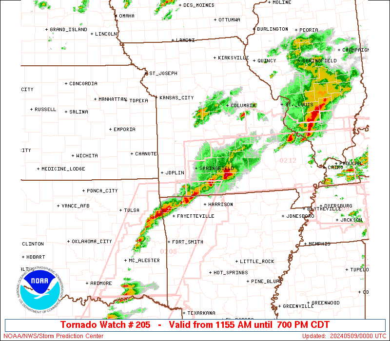
Tornado Watch Number 205
NWS Storm Prediction Center Norman OK
1155 AM CDT Wed May 8 2024
The NWS Storm Prediction Center has issued a
* Tornado Watch for portions of
Extreme southeast Kansas
Southern Missouri
* Effective this Wednesday morning and evening from 1155 AM until
700 PM CDT.
* Primary threats include...
A few tornadoes and a couple intense tornadoes possible
Scattered damaging winds and isolated significant gusts to 75
mph likely
Scattered large hail and isolated very large hail events to 3
inches in diameter likely
SUMMARY...Scattered supercell development is expected this afternoon
along and south of a slow-moving outflow boundary in Missouri. The
storm environment will be most favorable for tornadoes close to the
stalling outflow boundary, where an isolated strong (EF2+) tornado
will be possible. Otherwise, very large hail of 2-3 inches in
diameter will be possible with the supercells, and the potential for
damaging gusts up to 75 mph will increase with any upscale growth
into clusters.
The tornado watch area is approximately along and 50 statute miles
north and south of a line from 20 miles west northwest of Joplin MO
to 45 miles northeast of West Plains MO. For a complete depiction of
the watch see the associated watch outline update (WOUS64 KWNS
WOU5).
PRECAUTIONARY/PREPAREDNESS ACTIONS...
REMEMBER...A Tornado Watch means conditions are favorable for
tornadoes and severe thunderstorms in and close to the watch
area. Persons in these areas should be on the lookout for
threatening weather conditions and listen for later statements
and possible warnings.
&&
OTHER WATCH INFORMATION...CONTINUE...WW 202...WW 203...WW 204...
AVIATION...Tornadoes and a few severe thunderstorms with hail
surface and aloft to 3 inches. Extreme turbulence and surface wind
gusts to 65 knots. A few cumulonimbi with maximum tops to 550. Mean
storm motion vector 27030.
...Thompson

   SEL5

   URGENT - IMMEDIATE BROADCAST REQUESTED
   Tornado Watch Number 205
   NWS Storm Prediction Center Norman OK
   1155 AM CDT Wed May 8 2024

   The NWS Storm Prediction Center has issued a

   * Tornado Watch for portions of
     Extreme southeast Kansas
     Southern Missouri

   * Effective this Wednesday morning and evening from 1155 AM until
     700 PM CDT.

   * Primary threats include...
     A few tornadoes and a couple intense tornadoes possible
     Scattered damaging winds and isolated significant gusts to 75
       mph likely
     Scattered large hail and isolated very large hail events to 3
       inches in diameter likely

   SUMMARY...Scattered supercell development is expected this afternoon
   along and south of a slow-moving outflow boundary in Missouri.  The
   storm environment will be most favorable for tornadoes close to the
   stalling outflow boundary, where an isolated strong (EF2+) tornado
   will be possible.  Otherwise, very large hail of 2-3 inches in
   diameter will be possible with the supercells, and the potential for
   damaging gusts up to 75 mph will increase with any upscale growth
   into clusters.

   The tornado watch area is approximately along and 50 statute miles
   north and south of a line from 20 miles west northwest of Joplin MO
   to 45 miles northeast of West Plains MO. For a complete depiction of
   the watch see the associated watch outline update (WOUS64 KWNS
   WOU5).

   PRECAUTIONARY/PREPAREDNESS ACTIONS...

   REMEMBER...A Tornado Watch means conditions are favorable for
   tornadoes and severe thunderstorms in and close to the watch
   area. Persons in these areas should be on the lookout for
   threatening weather conditions and listen for later statements
   and possible warnings.

   &&

   OTHER WATCH INFORMATION...CONTINUE...WW 202...WW 203...WW 204...

   AVIATION...Tornadoes and a few severe thunderstorms with hail
   surface and aloft to 3 inches. Extreme turbulence and surface wind
   gusts to 65 knots. A few cumulonimbi with maximum tops to 550. Mean
   storm motion vector 27030.

   ...Thompson
 Note:
The Aviation Watch (SAW) product is an approximation to the watch area.
The actual watch is depicted by the shaded areas.
Note:
The Aviation Watch (SAW) product is an approximation to the watch area.
The actual watch is depicted by the shaded areas.
   SAW5
   WW 205 TORNADO KS MO 081655Z - 090000Z
   AXIS..50 STATUTE MILES NORTH AND SOUTH OF LINE..
   20WNW JLN/JOPLIN MO/ - 45NE UNO/WEST PLAINS MO/
   ..AVIATION COORDS.. 45NM N/S /19ENE OSW - 58WSW FAM/
   HAIL SURFACE AND ALOFT..3 INCHES. WIND GUSTS..65 KNOTS.
   MAX TOPS TO 550. MEAN STORM MOTION VECTOR 27030.

   LAT...LON 37989484 37939129 36499129 36549484

   THIS IS AN APPROXIMATION TO THE WATCH AREA.  FOR A
   COMPLETE DEPICTION OF THE WATCH SEE WOUS64 KWNS
   FOR WOU5.
Watch 205 Status Report Messages:
STATUS REPORT #8 ON WW 205

VALID 082335Z - 090040Z

SEVERE WEATHER THREAT CONTINUES RIGHT OF A LINE FROM 10 SSE GMJ
TO 10 SSW UMN TO 15 SE SGF TO 30 ENE SGF TO 35 WNW TBN TO 50 SE
SZL.

..BENTLEY..05/08/24

ATTN...WFO...SGF...

&&

STATUS REPORT FOR WT 205

SEVERE WEATHER THREAT CONTINUES FOR THE FOLLOWING AREAS

MOC029-119-185-090040-

MO
.    MISSOURI COUNTIES INCLUDED ARE

CAMDEN		     MCDONALD		 ST. CLAIR
$$


THE WATCH STATUS MESSAGE IS FOR GUIDANCE PURPOSES ONLY.  PLEASE
REFER TO WATCH COUNTY NOTIFICATION STATEMENTS FOR OFFICIAL
INFORMATION ON COUNTIES...INDEPENDENT CITIES AND MARINE ZONES
CLEARED FROM SEVERE THUNDERSTORM AND TORNADO WATCHES.
$$

STATUS REPORT #7 ON WW 205

VALID 082245Z - 082340Z

SEVERE WEATHER THREAT CONTINUES RIGHT OF A LINE FROM 15 WSW GMJ
TO 20 W UMN TO 20 N UMN TO 40 NW SGF TO 50 SW SZL.

..BENTLEY..05/08/24

ATTN...WFO...SGF...

&&

STATUS REPORT FOR WT 205

SEVERE WEATHER THREAT CONTINUES FOR THE FOLLOWING AREAS

MOC029-039-057-059-085-109-119-145-167-185-082340-

MO
.    MISSOURI COUNTIES INCLUDED ARE

CAMDEN		     CEDAR		 DADE
DALLAS		     HICKORY		 LAWRENCE
MCDONALD	     NEWTON		 POLK
ST. CLAIR
$$


THE WATCH STATUS MESSAGE IS FOR GUIDANCE PURPOSES ONLY.  PLEASE
REFER TO WATCH COUNTY NOTIFICATION STATEMENTS FOR OFFICIAL
INFORMATION ON COUNTIES...INDEPENDENT CITIES AND MARINE ZONES
CLEARED FROM SEVERE THUNDERSTORM AND TORNADO WATCHES.
$$

STATUS REPORT #6 ON WW 205

VALID 082145Z - 082240Z

SEVERE WEATHER THREAT CONTINUES RIGHT OF A LINE FROM 30 WNW JLN
TO 45 N JLN TO 40 SSE OJC.

..BENTLEY..05/08/24

ATTN...WFO...SGF...

&&

STATUS REPORT FOR WT 205

SEVERE WEATHER THREAT CONTINUES FOR THE FOLLOWING AREAS

KSC021-082240-

KS
.    KANSAS COUNTIES INCLUDED ARE

CHEROKEE
$$


MOC009-011-029-039-043-057-059-065-067-077-085-091-097-105-109-
119-145-149-153-161-167-169-185-203-209-213-215-217-225-229-
082240-

MO
.    MISSOURI COUNTIES INCLUDED ARE

BARRY		     BARTON		 CAMDEN
CEDAR		     CHRISTIAN		 DADE
DALLAS		     DENT		 DOUGLAS
GREENE		     HICKORY		 HOWELL
JASPER		     LACLEDE		 LAWRENCE
MCDONALD	     NEWTON		 OREGON
OZARK		     PHELPS		 POLK
PULASKI 	     ST. CLAIR		 SHANNON
STONE		     TANEY		 TEXAS
VERNON		     WEBSTER		 WRIGHT
$$


THE WATCH STATUS MESSAGE IS FOR GUIDANCE PURPOSES ONLY.  PLEASE
REFER TO WATCH COUNTY NOTIFICATION STATEMENTS FOR OFFICIAL
INFORMATION ON COUNTIES...INDEPENDENT CITIES AND MARINE ZONES
CLEARED FROM SEVERE THUNDERSTORM AND TORNADO WATCHES.
$$

STATUS REPORT #5 ON WW 205

VALID 082020Z - 082140Z

SEVERE WEATHER THREAT CONTINUES RIGHT OF A LINE FROM 25 WNW GMJ
TO 5 N JLN TO 45 SW SZL.

..BENTLEY..05/08/24

ATTN...WFO...SGF...

&&

STATUS REPORT FOR WT 205

SEVERE WEATHER THREAT CONTINUES FOR THE FOLLOWING AREAS

KSC021-082140-

KS
.    KANSAS COUNTIES INCLUDED ARE

CHEROKEE
$$


MOC009-011-029-039-043-057-059-065-067-077-085-091-097-105-109-
119-145-149-153-161-167-169-185-203-209-213-215-217-225-229-
082140-

MO
.    MISSOURI COUNTIES INCLUDED ARE

BARRY		     BARTON		 CAMDEN
CEDAR		     CHRISTIAN		 DADE
DALLAS		     DENT		 DOUGLAS
GREENE		     HICKORY		 HOWELL
JASPER		     LACLEDE		 LAWRENCE
MCDONALD	     NEWTON		 OREGON
OZARK		     PHELPS		 POLK
PULASKI 	     ST. CLAIR		 SHANNON
STONE		     TANEY		 TEXAS
VERNON		     WEBSTER		 WRIGHT
$$


THE WATCH STATUS MESSAGE IS FOR GUIDANCE PURPOSES ONLY.  PLEASE
REFER TO WATCH COUNTY NOTIFICATION STATEMENTS FOR OFFICIAL
INFORMATION ON COUNTIES...INDEPENDENT CITIES AND MARINE ZONES
CLEARED FROM SEVERE THUNDERSTORM AND TORNADO WATCHES.
$$

STATUS REPORT #4 ON WW 205

VALID 081925Z - 082040Z

SEVERE WEATHER THREAT CONTINUES RIGHT OF A LINE FROM 35 NW GMJ TO
25 NNW JLN TO 50 SW SZL.

..BENTLEY..05/08/24

ATTN...WFO...SGF...

&&

STATUS REPORT FOR WT 205

SEVERE WEATHER THREAT CONTINUES FOR THE FOLLOWING AREAS

KSC021-082040-

KS
.    KANSAS COUNTIES INCLUDED ARE

CHEROKEE
$$


MOC009-011-029-039-043-057-059-065-067-077-085-091-097-105-109-
119-145-149-153-161-167-169-185-203-209-213-215-217-225-229-
082040-

MO
.    MISSOURI COUNTIES INCLUDED ARE

BARRY		     BARTON		 CAMDEN
CEDAR		     CHRISTIAN		 DADE
DALLAS		     DENT		 DOUGLAS
GREENE		     HICKORY		 HOWELL
JASPER		     LACLEDE		 LAWRENCE
MCDONALD	     NEWTON		 OREGON
OZARK		     PHELPS		 POLK
PULASKI 	     ST. CLAIR		 SHANNON
STONE		     TANEY		 TEXAS
VERNON		     WEBSTER		 WRIGHT
$$


THE WATCH STATUS MESSAGE IS FOR GUIDANCE PURPOSES ONLY.  PLEASE
REFER TO WATCH COUNTY NOTIFICATION STATEMENTS FOR OFFICIAL
INFORMATION ON COUNTIES...INDEPENDENT CITIES AND MARINE ZONES
CLEARED FROM SEVERE THUNDERSTORM AND TORNADO WATCHES.
$$

STATUS REPORT #3 ON WW 205

VALID 081840Z - 081940Z

THE SEVERE WEATHER THREAT CONTINUES ACROSS THE ENTIRE WATCH AREA.

..BENTLEY..05/08/24

ATTN...WFO...SGF...

&&

STATUS REPORT FOR WT 205

SEVERE WEATHER THREAT CONTINUES FOR THE FOLLOWING AREAS

KSC011-021-037-081940-

KS
.    KANSAS COUNTIES INCLUDED ARE

BOURBON 	     CHEROKEE		 CRAWFORD
$$


MOC009-011-029-039-043-057-059-065-067-077-085-091-097-105-109-
119-145-149-153-161-167-169-185-203-209-213-215-217-225-229-
081940-

MO
.    MISSOURI COUNTIES INCLUDED ARE

BARRY		     BARTON		 CAMDEN
CEDAR		     CHRISTIAN		 DADE
DALLAS		     DENT		 DOUGLAS
GREENE		     HICKORY		 HOWELL
JASPER		     LACLEDE		 LAWRENCE
MCDONALD	     NEWTON		 OREGON
OZARK		     PHELPS		 POLK
PULASKI 	     ST. CLAIR		 SHANNON
STONE		     TANEY		 TEXAS
VERNON		     WEBSTER		 WRIGHT
$$


THE WATCH STATUS MESSAGE IS FOR GUIDANCE PURPOSES ONLY.  PLEASE
REFER TO WATCH COUNTY NOTIFICATION STATEMENTS FOR OFFICIAL
INFORMATION ON COUNTIES...INDEPENDENT CITIES AND MARINE ZONES
CLEARED FROM SEVERE THUNDERSTORM AND TORNADO WATCHES.
$$

STATUS REPORT #2 ON WW 205

VALID 081735Z - 081840Z

THE SEVERE WEATHER THREAT CONTINUES ACROSS THE ENTIRE WATCH AREA.

..BENTLEY..05/08/24

ATTN...WFO...SGF...

&&

STATUS REPORT FOR WT 205

SEVERE WEATHER THREAT CONTINUES FOR THE FOLLOWING AREAS

KSC011-021-037-081840-

KS
.    KANSAS COUNTIES INCLUDED ARE

BOURBON 	     CHEROKEE		 CRAWFORD
$$


MOC009-011-029-039-043-057-059-065-067-077-085-091-097-105-109-
119-145-149-153-161-167-169-185-203-209-213-215-217-225-229-
081840-

MO
.    MISSOURI COUNTIES INCLUDED ARE

BARRY		     BARTON		 CAMDEN
CEDAR		     CHRISTIAN		 DADE
DALLAS		     DENT		 DOUGLAS
GREENE		     HICKORY		 HOWELL
JASPER		     LACLEDE		 LAWRENCE
MCDONALD	     NEWTON		 OREGON
OZARK		     PHELPS		 POLK
PULASKI 	     ST. CLAIR		 SHANNON
STONE		     TANEY		 TEXAS
VERNON		     WEBSTER		 WRIGHT
$$


THE WATCH STATUS MESSAGE IS FOR GUIDANCE PURPOSES ONLY.  PLEASE
REFER TO WATCH COUNTY NOTIFICATION STATEMENTS FOR OFFICIAL
INFORMATION ON COUNTIES...INDEPENDENT CITIES AND MARINE ZONES
CLEARED FROM SEVERE THUNDERSTORM AND TORNADO WATCHES.
$$

STATUS REPORT #1 ON WW 205

VALID 081700Z - 081840Z

THE SEVERE WEATHER THREAT CONTINUES ACROSS THE ENTIRE WATCH AREA.

..BENTLEY..05/08/24

ATTN...WFO...SGF...

&&

STATUS REPORT FOR WT 205

SEVERE WEATHER THREAT CONTINUES FOR THE FOLLOWING AREAS

KSC011-021-037-081840-

KS
.    KANSAS COUNTIES INCLUDED ARE

BOURBON 	     CHEROKEE		 CRAWFORD
$$


MOC009-011-029-039-043-057-059-065-067-077-085-091-097-105-109-
119-145-149-153-161-167-169-185-203-209-213-215-217-225-229-
081840-

MO
.    MISSOURI COUNTIES INCLUDED ARE

BARRY		     BARTON		 CAMDEN
CEDAR		     CHRISTIAN		 DADE
DALLAS		     DENT		 DOUGLAS
GREENE		     HICKORY		 HOWELL
JASPER		     LACLEDE		 LAWRENCE
MCDONALD	     NEWTON		 OREGON
OZARK		     PHELPS		 POLK
PULASKI 	     ST. CLAIR		 SHANNON
STONE		     TANEY		 TEXAS
VERNON		     WEBSTER		 WRIGHT
$$


THE WATCH STATUS MESSAGE IS FOR GUIDANCE PURPOSES ONLY.  PLEASE
REFER TO WATCH COUNTY NOTIFICATION STATEMENTS FOR OFFICIAL
INFORMATION ON COUNTIES...INDEPENDENT CITIES AND MARINE ZONES
CLEARED FROM SEVERE THUNDERSTORM AND TORNADO WATCHES.
$$
Note:
Click for Complete Product Text.
Tornadoes
Probability of 2 or more tornadoes
|
Mod (50%)
|
Probability of 1 or more strong (EF2-EF5) tornadoes
|
Mod (30%)
|
Wind
Probability of 10 or more severe wind events
|
High (70%)
|
Probability of 1 or more wind events > 65 knots
|
High (70%)
|
Hail
Probability of 10 or more severe hail events
|
High (70%)
|
Probability of 1 or more hailstones > 2 inches
|
High (70%)
|
Combined Severe Hail/Wind
Probability of 6 or more combined severe hail/wind events
|
High (>95%)
|
For each watch, probabilities for particular events inside the watch
(listed above in each table) are determined by the issuing forecaster.
The "Low" category contains probability values ranging from less than 2%
to 20% (EF2-EF5 tornadoes), less than 5% to 20% (all other probabilities),
"Moderate" from 30% to 60%, and "High" from 70% to greater than 95%.
High values are bolded and lighter in color to provide awareness of
an increased threat for a particular event.


 @NWSSPC