Note:
The expiration time in the watch graphic is amended if the watch is
replaced, cancelled or extended.
Note:
Note:
The expiration time in the watch graphic is amended if the watch is
replaced, cancelled or extended.
Note: Click for
Watch Status Reports.
   SEL7

   URGENT - IMMEDIATE BROADCAST REQUESTED
   Severe Thunderstorm Watch Number 177
   NWS Storm Prediction Center Norman OK
   305 PM CDT Thu May 2 2024

   The NWS Storm Prediction Center has issued a

   * Severe Thunderstorm Watch for portions of
     Northwest and West Central Texas

   * Effective this Thursday afternoon and evening from 305 PM until
     1000 PM CDT.

   * Primary threats include...
     Scattered large hail and isolated very large hail events to 3
       inches in diameter likely
     Scattered damaging winds and isolated significant gusts to 75
       mph possible
     A tornado or two possible

   SUMMARY...Thunderstorms are expected to rapidly intensify this
   afternoon along a dryline, tracking slowly eastward across the watch
   area.  Very large hail and damaging winds will be possible with
   these storms.  A tornado or two is also possible.

   The severe thunderstorm watch area is approximately along and 45
   statute miles east and west of a line from 130 miles north of
   Abilene TX to 90 miles south southwest of Brownwood TX. For a
   complete depiction of the watch see the associated watch outline
   update (WOUS64 KWNS WOU7).

   PRECAUTIONARY/PREPAREDNESS ACTIONS...

   REMEMBER...A Severe Thunderstorm Watch means conditions are
   favorable for severe thunderstorms in and close to the watch area.
   Persons in these areas should be on the lookout for threatening
   weather conditions and listen for later statements and possible
   warnings. Severe thunderstorms can and occasionally do produce
   tornadoes.

   &&

   AVIATION...A few severe thunderstorms with hail surface and aloft to
   3 inches. Extreme turbulence and surface wind gusts to 65 knots. A
   few cumulonimbi with maximum tops to 550. Mean storm motion vector
   28025.

   ...Hart
 Note:
The Aviation Watch (SAW) product is an approximation to the watch area.
The actual watch is depicted by the shaded areas.
Note:
The Aviation Watch (SAW) product is an approximation to the watch area.
The actual watch is depicted by the shaded areas.
   SAW7
   WW 177 SEVERE TSTM TX 022005Z - 030300Z
   AXIS..45 STATUTE MILES EAST AND WEST OF LINE..
   130N ABI/ABILENE TX/ - 90SSW BWD/BROWNWOOD TX/
   ..AVIATION COORDS.. 40NM E/W /30E CDS - 15E JCT/
   HAIL SURFACE AND ALOFT..3 INCHES. WIND GUSTS..65 KNOTS.
   MAX TOPS TO 550. MEAN STORM MOTION VECTOR 28025.

   LAT...LON 34309889 30599877 30590029 34300047

   THIS IS AN APPROXIMATION TO THE WATCH AREA.  FOR A
   COMPLETE DEPICTION OF THE WATCH SEE WOUS64 KWNS
   FOR WOU7.
Watch 177 Status Report Messages:
STATUS REPORT #2 ON WW 177
VALID 030145Z - 030240Z
THE SEVERE WEATHER THREAT CONTINUES ACROSS THE ENTIRE WATCH AREA.
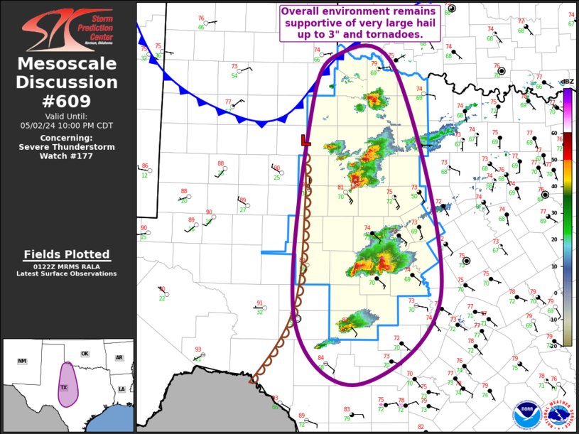
FOR ADDITIONAL INFORMATION SEE MESOSCALE DISCUSSION 609
..MOSIER..05/03/24
ATTN...WFO...OUN...SJT...FWD...LUB...
&&
STATUS REPORT FOR WS 177
SEVERE WEATHER THREAT CONTINUES FOR THE FOLLOWING AREAS
TXC009-023-049-059-081-083-093-095-133-151-155-197-207-253-267-
269-275-307-319-327-333-353-399-411-417-429-433-441-447-451-485-
487-503-030240-
TX
. TEXAS COUNTIES INCLUDED ARE
ARCHER BAYLOR BROWN
CALLAHAN COKE COLEMAN
COMANCHE CONCHO EASTLAND
FISHER FOARD HARDEMAN
HASKELL JONES KIMBLE
KING KNOX MCCULLOCH
MASON MENARD MILLS
NOLAN RUNNELS SAN SABA
SHACKELFORD STEPHENS STONEWALL
TAYLOR THROCKMORTON TOM GREEN
WICHITA WILBARGER YOUNG
$$
THE WATCH STATUS MESSAGE IS FOR GUIDANCE PURPOSES ONLY. PLEASE
REFER TO WATCH COUNTY NOTIFICATION STATEMENTS FOR OFFICIAL
INFORMATION ON COUNTIES...INDEPENDENT CITIES AND MARINE ZONES
CLEARED FROM SEVERE THUNDERSTORM AND TORNADO WATCHES.
$$
STATUS REPORT #1 ON WW 177
VALID 022345Z - 030040Z
THE SEVERE WEATHER THREAT CONTINUES ACROSS THE ENTIRE WATCH AREA.
FOR ADDITIONAL INFORMATION SEE MESOSCALE DISCUSSION 607
..MOSIER..05/02/24
ATTN...WFO...OUN...SJT...FWD...LUB...
&&
STATUS REPORT FOR WS 177
SEVERE WEATHER THREAT CONTINUES FOR THE FOLLOWING AREAS
TXC009-023-049-059-081-083-093-095-133-151-155-197-207-253-267-
269-275-307-319-327-333-353-399-411-417-429-433-441-447-451-485-
487-503-030040-
TX
. TEXAS COUNTIES INCLUDED ARE
ARCHER BAYLOR BROWN
CALLAHAN COKE COLEMAN
COMANCHE CONCHO EASTLAND
FISHER FOARD HARDEMAN
HASKELL JONES KIMBLE
KING KNOX MCCULLOCH
MASON MENARD MILLS
NOLAN RUNNELS SAN SABA
SHACKELFORD STEPHENS STONEWALL
TAYLOR THROCKMORTON TOM GREEN
WICHITA WILBARGER YOUNG
$$
THE WATCH STATUS MESSAGE IS FOR GUIDANCE PURPOSES ONLY. PLEASE
REFER TO WATCH COUNTY NOTIFICATION STATEMENTS FOR OFFICIAL
INFORMATION ON COUNTIES...INDEPENDENT CITIES AND MARINE ZONES
CLEARED FROM SEVERE THUNDERSTORM AND TORNADO WATCHES.
$$
Note:
Click for Complete Product Text.
Tornadoes
Probability of 2 or more tornadoes
|
Low (20%)
|
Probability of 1 or more strong (EF2-EF5) tornadoes
|
Low (5%)
|
Wind
Probability of 10 or more severe wind events
|
Mod (40%)
|
Probability of 1 or more wind events > 65 knots
|
Mod (30%)
|
Hail
Probability of 10 or more severe hail events
|
High (70%)
|
Probability of 1 or more hailstones > 2 inches
|
Mod (60%)
|
Combined Severe Hail/Wind
Probability of 6 or more combined severe hail/wind events
|
High (90%)
|
For each watch, probabilities for particular events inside the watch
(listed above in each table) are determined by the issuing forecaster.
The "Low" category contains probability values ranging from less than 2%
to 20% (EF2-EF5 tornadoes), less than 5% to 20% (all other probabilities),
"Moderate" from 30% to 60%, and "High" from 70% to greater than 95%.
High values are bolded and lighter in color to provide awareness of
an increased threat for a particular event.


 @NWSSPC