Note:
The expiration time in the watch graphic is amended if the watch is
replaced, cancelled or extended.
Note:
Note:
The expiration time in the watch graphic is amended if the watch is
replaced, cancelled or extended.
Note: Click for
Watch Status Reports.
SEL7
URGENT - IMMEDIATE BROADCAST REQUESTED
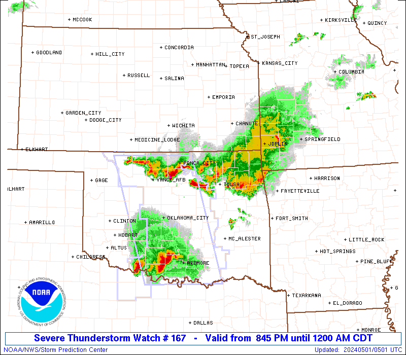
Severe Thunderstorm Watch Number 167
NWS Storm Prediction Center Norman OK
845 PM CDT Tue Apr 30 2024
The NWS Storm Prediction Center has issued a
* Severe Thunderstorm Watch for portions of
Northeast Oklahoma
* Effective this Tuesday night from 845 PM until Midnight CDT.
* Primary threats include...
Scattered damaging winds and isolated significant gusts to 75
mph possible
Isolated large hail events to 1.5 inches in diameter possible
SUMMARY...A band of severe thunderstorms will likely progress
east-southeast across portions of northern and northeast Oklahoma
through the late evening. Severe gusts and associated wind damage
will be the primary severe hazards accompanying this thunderstorm
complex.
The severe thunderstorm watch area is approximately along and 35
statute miles north and south of a line from 50 miles west southwest
of Bartlesville OK to 35 miles east northeast of Tulsa OK. For a
complete depiction of the watch see the associated watch outline
update (WOUS64 KWNS WOU7).
PRECAUTIONARY/PREPAREDNESS ACTIONS...
REMEMBER...A Severe Thunderstorm Watch means conditions are
favorable for severe thunderstorms in and close to the watch area.
Persons in these areas should be on the lookout for threatening
weather conditions and listen for later statements and possible
warnings. Severe thunderstorms can and occasionally do produce
tornadoes.
&&
OTHER WATCH INFORMATION...CONTINUE...WW 163...WW 164...WW
165...WW 166...
AVIATION...A few severe thunderstorms with hail surface and aloft to
1.5 inches. Extreme turbulence and surface wind gusts to 65 knots. A
few cumulonimbi with maximum tops to 450. Mean storm motion vector
29030.
...Smith
 Note:
The Aviation Watch (SAW) product is an approximation to the watch area.
The actual watch is depicted by the shaded areas.
Note:
The Aviation Watch (SAW) product is an approximation to the watch area.
The actual watch is depicted by the shaded areas.
   SAW7
   WW 167 SEVERE TSTM OK 010145Z - 010500Z
   AXIS..35 STATUTE MILES NORTH AND SOUTH OF LINE..
   50WSW BVO/BARTLESVILLE OK/ - 35ENE TUL/TULSA OK/
   ..AVIATION COORDS.. 30NM N/S /52E END - 26ENE TUL/
   HAIL SURFACE AND ALOFT..1.5 INCHES. WIND GUSTS..65 KNOTS.
   MAX TOPS TO 450. MEAN STORM MOTION VECTOR 29030.

   LAT...LON 37009685 36909530 35899530 35989685

   THIS IS AN APPROXIMATION TO THE WATCH AREA.  FOR A
   COMPLETE DEPICTION OF THE WATCH SEE WOUS64 KWNS
   FOR WOU7.
Watch 167 Status Report Messages:
STATUS REPORT #1 ON WW 167

VALID 010250Z - 010340Z

THE SEVERE WEATHER THREAT CONTINUES ACROSS THE ENTIRE WATCH AREA.

FOR ADDITIONAL INFORMATION SEE MESOSCALE DISCUSSION 585

..THORNTON..05/01/24

ATTN...WFO...TSA...

&&

STATUS REPORT FOR WS 167

SEVERE WEATHER THREAT CONTINUES FOR THE FOLLOWING AREAS

OKC035-037-097-105-113-117-131-143-145-147-010340-

OK
.    OKLAHOMA COUNTIES INCLUDED ARE

CRAIG		     CREEK		 MAYES
NOWATA		     OSAGE		 PAWNEE
ROGERS		     TULSA		 WAGONER
WASHINGTON
$$


THE WATCH STATUS MESSAGE IS FOR GUIDANCE PURPOSES ONLY.  PLEASE
REFER TO WATCH COUNTY NOTIFICATION STATEMENTS FOR OFFICIAL
INFORMATION ON COUNTIES...INDEPENDENT CITIES AND MARINE ZONES
CLEARED FROM SEVERE THUNDERSTORM AND TORNADO WATCHES.
$$
Note:
Click for Complete Product Text.
Tornadoes
Probability of 2 or more tornadoes
|
Low (10%)
|
Probability of 1 or more strong (EF2-EF5) tornadoes
|
Low (<2%)
|
Wind
Probability of 10 or more severe wind events
|
Mod (40%)
|
Probability of 1 or more wind events > 65 knots
|
Mod (30%)
|
Hail
Probability of 10 or more severe hail events
|
Low (20%)
|
Probability of 1 or more hailstones > 2 inches
|
Low (10%)
|
Combined Severe Hail/Wind
Probability of 6 or more combined severe hail/wind events
|
Mod (60%)
|
For each watch, probabilities for particular events inside the watch
(listed above in each table) are determined by the issuing forecaster.
The "Low" category contains probability values ranging from less than 2%
to 20% (EF2-EF5 tornadoes), less than 5% to 20% (all other probabilities),
"Moderate" from 30% to 60%, and "High" from 70% to greater than 95%.
High values are bolded and lighter in color to provide awareness of
an increased threat for a particular event.


 @NWSSPC