 Note:
The expiration time in the watch graphic is amended if the watch is
replaced, cancelled or extended.
Note:
Note:
The expiration time in the watch graphic is amended if the watch is
replaced, cancelled or extended.
Note: Click for
Watch Status Reports.
SEL2
URGENT - IMMEDIATE BROADCAST REQUESTED
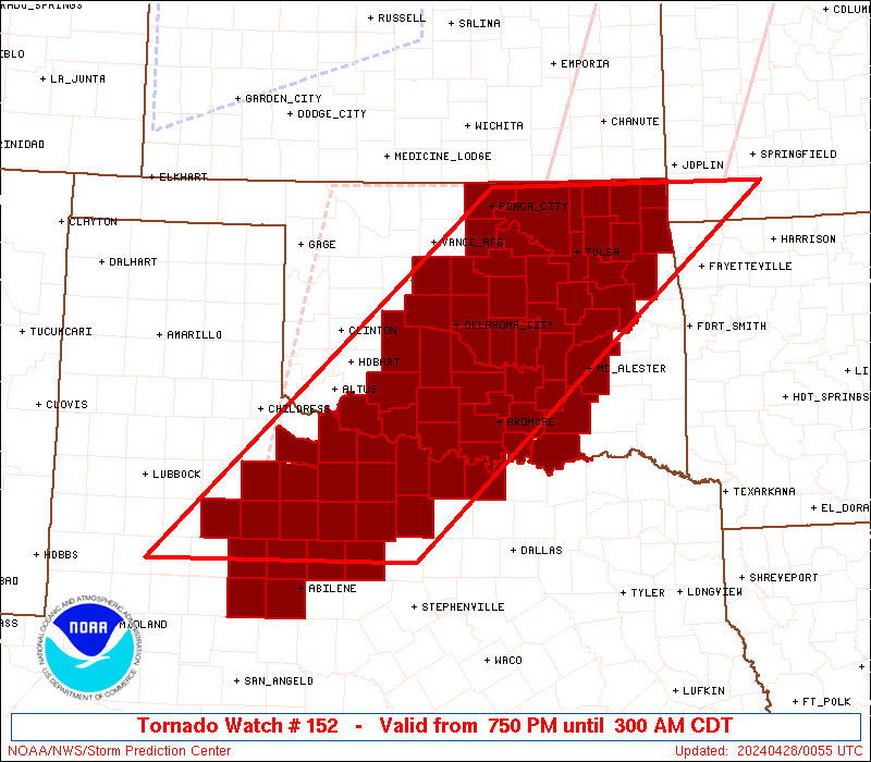
Tornado Watch Number 152
NWS Storm Prediction Center Norman OK
750 PM CDT Sat Apr 27 2024
The NWS Storm Prediction Center has issued a
* Tornado Watch for portions of
Southern, Central, and Northeast Oklahoma
Northwest Texas
* Effective this Saturday night and Sunday morning from 750 PM
until 300 AM CDT.
* Primary threats include...
A few tornadoes likely with a couple intense tornadoes possible
Widespread large hail and isolated very large hail events to 2
inches in diameter likely
Scattered damaging wind gusts to 70 mph likely
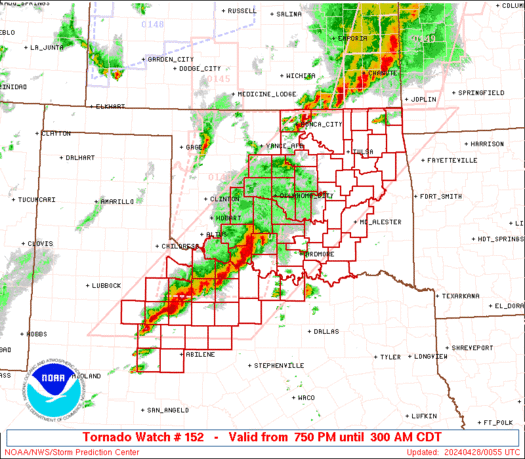
SUMMARY...Bands of severe storms, including embedded supercells,
will continue through the evening as a low-level jet intensifies
across the Watch area. A very moist and strongly sheared
environment will support the threat for tornadoes, potentially
strong, and large hail and severe gusts into the overnight.
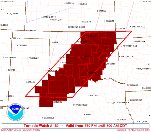
The tornado watch area is approximately along and 105 statute miles
east and west of a line from 35 miles northwest of Grove OK to 120
miles southwest of Wichita Falls TX. For a complete depiction of the
watch see the associated watch outline update (WOUS64 KWNS WOU2).
PRECAUTIONARY/PREPAREDNESS ACTIONS...
REMEMBER...A Tornado Watch means conditions are favorable for
tornadoes and severe thunderstorms in and close to the watch
area. Persons in these areas should be on the lookout for
threatening weather conditions and listen for later statements
and possible warnings.
&&
OTHER WATCH INFORMATION...CONTINUE...WW 146...WW 147...WW
148...WW 149...WW 150...WW 151...
AVIATION...Tornadoes and a few severe thunderstorms with hail
surface and aloft to 2 inches. Extreme turbulence and surface wind
gusts to 60 knots. A few cumulonimbi with maximum tops to 500. Mean
storm motion vector 24035.
...Smith

   SEL2

   URGENT - IMMEDIATE BROADCAST REQUESTED
   Tornado Watch Number 152
   NWS Storm Prediction Center Norman OK
   750 PM CDT Sat Apr 27 2024

   The NWS Storm Prediction Center has issued a

   * Tornado Watch for portions of
     Southern, Central, and Northeast Oklahoma
     Northwest Texas

   * Effective this Saturday night and Sunday morning from 750 PM
     until 300 AM CDT.

   * Primary threats include...
     A few tornadoes likely with a couple intense tornadoes possible
     Widespread large hail and isolated very large hail events to 2
       inches in diameter likely
     Scattered damaging wind gusts to 70 mph likely

   SUMMARY...Bands of severe storms, including embedded supercells,
   will continue through the evening as a low-level jet intensifies
   across the Watch area.  A very moist and strongly sheared
   environment will support the threat for tornadoes, potentially
   strong, and large hail and severe gusts into the overnight.

   The tornado watch area is approximately along and 105 statute miles
   east and west of a line from 35 miles northwest of Grove OK to 120
   miles southwest of Wichita Falls TX. For a complete depiction of the
   watch see the associated watch outline update (WOUS64 KWNS WOU2).

   PRECAUTIONARY/PREPAREDNESS ACTIONS...

   REMEMBER...A Tornado Watch means conditions are favorable for
   tornadoes and severe thunderstorms in and close to the watch
   area. Persons in these areas should be on the lookout for
   threatening weather conditions and listen for later statements
   and possible warnings.

   &&

   OTHER WATCH INFORMATION...CONTINUE...WW 146...WW 147...WW
   148...WW 149...WW 150...WW 151...

   AVIATION...Tornadoes and a few severe thunderstorms with hail
   surface and aloft to 2 inches. Extreme turbulence and surface wind
   gusts to 60 knots. A few cumulonimbi with maximum tops to 500. Mean
   storm motion vector 24035.

   ...Smith
 Note:
The Aviation Watch (SAW) product is an approximation to the watch area.
The actual watch is depicted by the shaded areas.
Note:
The Aviation Watch (SAW) product is an approximation to the watch area.
The actual watch is depicted by the shaded areas.
   SAW2
   WW 152 TORNADO OK TX 280050Z - 280800Z
   AXIS..105 STATUTE MILES EAST AND WEST OF LINE..
   35NW GMJ/GROVE OK/ - 120SW SPS/WICHITA FALLS TX/
   ..AVIATION COORDS.. 90NM E/W /11S OSW - 16NNW ABI/
   HAIL SURFACE AND ALOFT..2 INCHES. WIND GUSTS..60 KNOTS.
   MAX TOPS TO 500. MEAN STORM MOTION VECTOR 24035.

   LAT...LON 36959329 32729815 32720177 36959709

   THIS IS AN APPROXIMATION TO THE WATCH AREA.  FOR A
   COMPLETE DEPICTION OF THE WATCH SEE WOUS64 KWNS
   FOR WOU2.
Watch 152 Status Report Messages:
STATUS REPORT #1 ON WW 152

VALID 280545Z - 280640Z

SEVERE WEATHER THREAT CONTINUES RIGHT OF A LINE FROM 30 S ABI TO
5 SSE ABI TO 40 NE ABI TO 30 ESE SPS TO 45 E SPS TO 35 WNW MLC TO
10 SW TUL TO 25 NE BVO.

..LEITMAN..04/28/24

ATTN...WFO...OUN...TSA...FWD...SJT...LUB...

&&

STATUS REPORT FOR WT 152

SEVERE WEATHER THREAT CONTINUES FOR THE FOLLOWING AREAS

OKC005-013-019-021-029-035-041-063-067-069-085-091-095-097-099-
101-105-107-111-115-121-123-131-143-145-280640-

OK
.    OKLAHOMA COUNTIES INCLUDED ARE

ATOKA		     BRYAN		 CARTER
CHEROKEE	     COAL		 CRAIG
DELAWARE	     HUGHES		 JEFFERSON
JOHNSTON	     LOVE		 MCINTOSH
MARSHALL	     MAYES		 MURRAY
MUSKOGEE	     NOWATA		 OKFUSKEE
OKMULGEE	     OTTAWA		 PITTSBURG
PONTOTOC	     ROGERS		 TULSA
WAGONER
$$


TXC077-097-133-237-337-363-417-429-497-503-280640-

TX
.    TEXAS COUNTIES INCLUDED ARE

CLAY		     COOKE		 EASTLAND
JACK		     MONTAGUE		 PALO PINTO
SHACKELFORD	     STEPHENS		 WISE
YOUNG
$$


THE WATCH STATUS MESSAGE IS FOR GUIDANCE PURPOSES ONLY.  PLEASE
REFER TO WATCH COUNTY NOTIFICATION STATEMENTS FOR OFFICIAL
INFORMATION ON COUNTIES...INDEPENDENT CITIES AND MARINE ZONES
CLEARED FROM SEVERE THUNDERSTORM AND TORNADO WATCHES.
$$
Note:
Click for Complete Product Text.
Tornadoes
Probability of 2 or more tornadoes
|
High (70%)
|
Probability of 1 or more strong (EF2-EF5) tornadoes
|
Mod (40%)
|
Wind
Probability of 10 or more severe wind events
|
High (70%)
|
Probability of 1 or more wind events > 65 knots
|
Low (10%)
|
Hail
Probability of 10 or more severe hail events
|
High (80%)
|
Probability of 1 or more hailstones > 2 inches
|
Mod (60%)
|
Combined Severe Hail/Wind
Probability of 6 or more combined severe hail/wind events
|
High (>95%)
|
For each watch, probabilities for particular events inside the watch
(listed above in each table) are determined by the issuing forecaster.
The "Low" category contains probability values ranging from less than 2%
to 20% (EF2-EF5 tornadoes), less than 5% to 20% (all other probabilities),
"Moderate" from 30% to 60%, and "High" from 70% to greater than 95%.
High values are bolded and lighter in color to provide awareness of
an increased threat for a particular event.


 @NWSSPC