 Note:
The expiration time in the watch graphic is amended if the watch is
replaced, cancelled or extended.
Note:
Note:
The expiration time in the watch graphic is amended if the watch is
replaced, cancelled or extended.
Note: Click for
Watch Status Reports.
SEL8
URGENT - IMMEDIATE BROADCAST REQUESTED
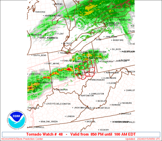
Tornado Watch Number 48
NWS Storm Prediction Center Norman OK
850 PM EDT Thu Mar 14 2024
The NWS Storm Prediction Center has issued a
* Tornado Watch for portions of
Southeast Ohio
* Effective this Thursday night and Friday morning from 850 PM
until 100 AM EDT.
* Primary threats include...
A couple tornadoes possible
Scattered damaging wind gusts to 65 mph possible
Isolated large hail events to 1.5 inches in diameter possible
SUMMARY...Isolated intense supercells with a history of tornadoes
over central Ohio may persist another few hours and track into watch
area. If they do, isolated tornadoes and damaging winds would be
possible in the strongest cells.
The tornado watch area is approximately along and 35 statute miles
north and south of a line from 40 miles west northwest of Zanesville
OH to 5 miles northeast of Wheeling WV. For a complete depiction of
the watch see the associated watch outline update (WOUS64 KWNS
WOU8).
PRECAUTIONARY/PREPAREDNESS ACTIONS...
REMEMBER...A Tornado Watch means conditions are favorable for
tornadoes and severe thunderstorms in and close to the watch
area. Persons in these areas should be on the lookout for
threatening weather conditions and listen for later statements
and possible warnings.
&&
OTHER WATCH INFORMATION...CONTINUE...WW 43...WW 44...WW 45...WW
46...WW 47...
AVIATION...Tornadoes and a few severe thunderstorms with hail
surface and aloft to 1.5 inches. Extreme turbulence and surface wind
gusts to 55 knots. A few cumulonimbi with maximum tops to 500. Mean
storm motion vector 27030.
...Hart

   SEL8

   URGENT - IMMEDIATE BROADCAST REQUESTED
   Tornado Watch Number 48
   NWS Storm Prediction Center Norman OK
   850 PM EDT Thu Mar 14 2024

   The NWS Storm Prediction Center has issued a

   * Tornado Watch for portions of
     Southeast Ohio

   * Effective this Thursday night and Friday morning from 850 PM
     until 100 AM EDT.

   * Primary threats include...
     A couple tornadoes possible
     Scattered damaging wind gusts to 65 mph possible
     Isolated large hail events to 1.5 inches in diameter possible

   SUMMARY...Isolated intense supercells with a history of tornadoes
   over central Ohio may persist another few hours and track into watch
   area.  If they do, isolated tornadoes and damaging winds would be
   possible in the strongest cells.

   The tornado watch area is approximately along and 35 statute miles
   north and south of a line from 40 miles west northwest of Zanesville
   OH to 5 miles northeast of Wheeling WV. For a complete depiction of
   the watch see the associated watch outline update (WOUS64 KWNS
   WOU8).

   PRECAUTIONARY/PREPAREDNESS ACTIONS...

   REMEMBER...A Tornado Watch means conditions are favorable for
   tornadoes and severe thunderstorms in and close to the watch
   area. Persons in these areas should be on the lookout for
   threatening weather conditions and listen for later statements
   and possible warnings.

   &&

   OTHER WATCH INFORMATION...CONTINUE...WW 43...WW 44...WW 45...WW
   46...WW 47...

   AVIATION...Tornadoes and a few severe thunderstorms with hail
   surface and aloft to 1.5 inches. Extreme turbulence and surface wind
   gusts to 55 knots. A few cumulonimbi with maximum tops to 500. Mean
   storm motion vector 27030.

   ...Hart
 Note:
The Aviation Watch (SAW) product is an approximation to the watch area.
The actual watch is depicted by the shaded areas.
Note:
The Aviation Watch (SAW) product is an approximation to the watch area.
The actual watch is depicted by the shaded areas.
   SAW8
   WW 48 TORNADO OH 150050Z - 150500Z
   AXIS..35 STATUTE MILES NORTH AND SOUTH OF LINE..
   40WNW ZZV/ZANESVILLE OH/ - 5NE HLG/WHEELING WV/
   ..AVIATION COORDS.. 30NM N/S /1NNW APE - 17NE AIR/
   HAIL SURFACE AND ALOFT..1.5 INCHES. WIND GUSTS..55 KNOTS.
   MAX TOPS TO 500. MEAN STORM MOTION VECTOR 27030.

   LAT...LON 40688260 40748058 39728058 39668260

   THIS IS AN APPROXIMATION TO THE WATCH AREA.  FOR A
   COMPLETE DEPICTION OF THE WATCH SEE WOUS64 KWNS
   FOR WOU8.
Watch 48 Status Report Messages:
STATUS REPORT #2 ON WW 48

VALID 150225Z - 150340Z

SEVERE WEATHER THREAT CONTINUES RIGHT OF A LINE FROM 15 NE CMH TO
25 NNE ZZV TO 10 W PIT.

..WENDT..03/15/24

ATTN...WFO...PBZ...RLX...

&&

STATUS REPORT FOR WT 48

SEVERE WEATHER THREAT CONTINUES FOR THE FOLLOWING AREAS

OHC013-059-067-111-115-119-121-127-150340-

OH
.    OHIO COUNTIES INCLUDED ARE

BELMONT 	     GUERNSEY		 HARRISON
MONROE		     MORGAN		 MUSKINGUM
NOBLE		     PERRY
$$


THE WATCH STATUS MESSAGE IS FOR GUIDANCE PURPOSES ONLY.  PLEASE
REFER TO WATCH COUNTY NOTIFICATION STATEMENTS FOR OFFICIAL
INFORMATION ON COUNTIES...INDEPENDENT CITIES AND MARINE ZONES
CLEARED FROM SEVERE THUNDERSTORM AND TORNADO WATCHES.
$$

STATUS REPORT #1 ON WW 48

VALID 150150Z - 150240Z

THE SEVERE WEATHER THREAT CONTINUES ACROSS THE ENTIRE WATCH AREA.

..SQUITIERI..03/15/24

ATTN...WFO...PBZ...RLX...

&&

STATUS REPORT FOR WT 48

SEVERE WEATHER THREAT CONTINUES FOR THE FOLLOWING AREAS

OHC013-019-031-059-067-111-115-119-121-127-157-150240-

OH
.    OHIO COUNTIES INCLUDED ARE

BELMONT 	     CARROLL		 COSHOCTON
GUERNSEY	     HARRISON		 MONROE
MORGAN		     MUSKINGUM		 NOBLE
PERRY		     TUSCARAWAS
$$


THE WATCH STATUS MESSAGE IS FOR GUIDANCE PURPOSES ONLY.  PLEASE
REFER TO WATCH COUNTY NOTIFICATION STATEMENTS FOR OFFICIAL
INFORMATION ON COUNTIES...INDEPENDENT CITIES AND MARINE ZONES
CLEARED FROM SEVERE THUNDERSTORM AND TORNADO WATCHES.
$$
Note:
Click for Complete Product Text.
Tornadoes
Probability of 2 or more tornadoes
|
Mod (30%)
|
Probability of 1 or more strong (EF2-EF5) tornadoes
|
Low (10%)
|
Wind
Probability of 10 or more severe wind events
|
Mod (40%)
|
Probability of 1 or more wind events > 65 knots
|
Low (20%)
|
Hail
Probability of 10 or more severe hail events
|
Mod (30%)
|
Probability of 1 or more hailstones > 2 inches
|
Low (20%)
|
Combined Severe Hail/Wind
Probability of 6 or more combined severe hail/wind events
|
High (70%)
|
For each watch, probabilities for particular events inside the watch
(listed above in each table) are determined by the issuing forecaster.
The "Low" category contains probability values ranging from less than 2%
to 20% (EF2-EF5 tornadoes), less than 5% to 20% (all other probabilities),
"Moderate" from 30% to 60%, and "High" from 70% to greater than 95%.
High values are bolded and lighter in color to provide awareness of
an increased threat for a particular event.


 @NWSSPC


